![](/images/other/stat-length.png)
![Excursión Senderismo Noyers-sur-Jabron - Les Chapelles du vieux Noyer - Photo](https://media.geolcdn.com/t/1900/400/55ddb9cc-d3b4-4fcd-8542-d744e23afb72.jpg&format=pjpeg&maxdim=2)
Les Chapelles du vieux Noyer
liocol
Usuario
![Longitud](/images/other/stat-length.png)
![Altitud máxima](https://static1.geolcdn.com/siteimages/upload/files/1508320355ic_sort_altitude_max_24dp.png)
![Desnivel positivo](https://static1.geolcdn.com/siteimages/upload/files/1508320355ic_sort_den_pos_24dp.png)
![Km-Effort](/images/other/stat-length.png)
![Altitud mínima](https://static1.geolcdn.com/siteimages/upload/files/1508320355ic_sort_altitude_min_24dp.png)
![Desnivel negativo](https://static1.geolcdn.com/siteimages/upload/files/1508320355ic_sort_den_neg_24dp.png)
![Boucle](https://static1.geolcdn.com/siteimages/upload/files/16400158638029165_repeat_loop_refresh_sync_direction_icon.png)
![Senderismo](https://static1.geolcdn.com/sitytour/trail-icons/101.png)
4h02
Dificultad : Medio
![Escanee este código QR para abrir la excursión en la aplicación SityTrail](https://capi.geolives.com/qq0zvz2zws4bq2lad0pu/sitytour/trails/3467723/qr.png?size=200)
Aplicación GPS de excursión GRATIS
A propósito
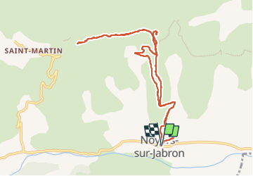
Ruta Senderismo de 10,6 km a descubrir en Provenza-Alpes-Costa Azul, Alpes de Alta Provenza, Noyers-sur-Jabron. Esta ruta ha sido propuesta por liocol.
Descripción
Après le village en ruine, vous pouvez faire le petit détour en demandant l’autorisation ( chemin privé ).
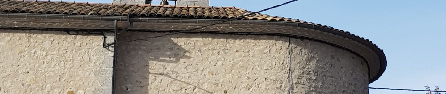
Le vieux Noyer, ce village comprenait 1500 âmes avant la guerre de 1914, par un manque d'hommes après la guerre, les femmes sont descendues dans la vallée.
Localización
Comentarios
Excursiones cerca
![Excursión Senderismo Valbelle - VALBELLE . Chemin de Sara o l s - Photo](https://media.geolcdn.com/t/375/260/f5bc0f94-fea9-4cf8-899a-951c04f93f5f.jpg&format=jpg&maxdim=2)
![Senderismo Senderismo](https://static1.geolcdn.com/sitytour/trail-icons/101.png)
Senderismo
![](/images/other/stat-length.png)
![](https://static1.geolcdn.com/siteimages/upload/files/16400158638029165_repeat_loop_refresh_sync_direction_icon.png)
![Excursión Senderismo Valbelle - 05 chap st Pons col sumiou zel - Photo](https://media.geolcdn.com/t/375/260/654eadec-c68c-403c-8c9b-a622285d41ca.jpg&format=jpg&maxdim=2)
![Senderismo Senderismo](https://static1.geolcdn.com/sitytour/trail-icons/101.png)
Senderismo
![](/images/other/stat-length.png)
![](https://static1.geolcdn.com/siteimages/upload/files/16400158638029165_repeat_loop_refresh_sync_direction_icon.png)
![Excursión Senderismo Valbelle - chapelle saint Pont et montagne Sumiou - Photo](https://media.geolcdn.com/t/375/260/36d6cde7-c446-427e-9ab1-73d7e5890674.jpg&format=jpg&maxdim=2)
![Senderismo Senderismo](https://static1.geolcdn.com/sitytour/trail-icons/101.png)
Senderismo
![](/images/other/stat-length.png)
![](https://static1.geolcdn.com/siteimages/upload/files/16400158638029165_repeat_loop_refresh_sync_direction_icon.png)
![Excursión A pie Noyers-sur-Jabron - Montagne de Sumiou - Grotte des Peyrouets_19_01_2024 - Photo](https://media.geolcdn.com/t/375/260/d885e4ac-abdf-4f73-b427-5e5b97ac821b.jpg&format=jpg&maxdim=2)
![A pie A pie](https://static1.geolcdn.com/sitytour/trail-icons/100.png)
A pie
![](/images/other/stat-length.png)
![](https://static1.geolcdn.com/siteimages/upload/files/16400158638029165_repeat_loop_refresh_sync_direction_icon.png)
![Excursión Senderismo Valbelle - 04 chapelle St Pons 03.08.23 - Photo](https://media.geolcdn.com/t/375/260/a22dc00e-ca36-48e1-a26c-c25718a9238f.jpg&format=jpg&maxdim=2)
![Senderismo Senderismo](https://static1.geolcdn.com/sitytour/trail-icons/101.png)
Senderismo
![](/images/other/stat-length.png)
![](https://static1.geolcdn.com/siteimages/upload/files/16400158638029165_repeat_loop_refresh_sync_direction_icon.png)
![Excursión Senderismo Val-Buëch-Méouge - Rocher de pierre Impie, roc de l'aigle, pas de Berches - Photo](https://media.geolcdn.com/t/375/260/872433af-29da-42c0-940a-93266e0778d4.jpg&format=jpg&maxdim=2)
![Senderismo Senderismo](https://static1.geolcdn.com/sitytour/trail-icons/101.png)
Senderismo
![](/images/other/stat-length.png)
![](https://static1.geolcdn.com/siteimages/upload/files/16400158638029165_repeat_loop_refresh_sync_direction_icon.png)
![Excursión Senderismo Noyers-sur-Jabron - SityTrail - NOYERS SUR JABRON , S Martin , col S Pierre , cretes de l ane n - Photo](https://media.geolcdn.com/t/375/260/b5b69900-a4cf-40a0-8395-e0fe0112d265.jpg&format=jpg&maxdim=2)
![Senderismo Senderismo](https://static1.geolcdn.com/sitytour/trail-icons/101.png)
Senderismo
![](/images/other/stat-length.png)
![](https://static1.geolcdn.com/siteimages/upload/files/16400158638029165_repeat_loop_refresh_sync_direction_icon.png)
![Excursión A pie Valbelle - Montagne de Lure - Photo](https://media.geolcdn.com/t/375/260/d2f7e93b-ac8d-4890-bbc4-c62d8ad565bf.jpg&format=jpg&maxdim=2)
![A pie A pie](https://static1.geolcdn.com/sitytour/trail-icons/100.png)
A pie
![](/images/other/stat-length.png)
![](https://static1.geolcdn.com/siteimages/upload/files/16400158638029165_repeat_loop_refresh_sync_direction_icon.png)
![Excursión Senderismo Valbelle - Tour de Sumiou - Photo](https://media.geolcdn.com/t/375/260/98046d43-9799-41dd-91ec-957f42022344.jpg&format=jpg&maxdim=2)
![Senderismo Senderismo](https://static1.geolcdn.com/sitytour/trail-icons/101.png)
Senderismo
![](/images/other/stat-length.png)
![](https://static1.geolcdn.com/siteimages/upload/files/16400158638029165_repeat_loop_refresh_sync_direction_icon.png)