![](/images/other/stat-length.png)
![Excursión Senderismo Saint-Bauzile - Saint bauzille - Photo](https://media.geolcdn.com/t/1900/400/74205e6c-fb7a-4697-a75b-fadc9534f7ef.jpg&format=pjpeg&maxdim=2)
Saint bauzille
Vero7684
Usuario
![Longitud](/images/other/stat-length.png)
Longitud
18,4 km
![Altitud máxima](https://static1.geolcdn.com/siteimages/upload/files/1508320355ic_sort_altitude_max_24dp.png)
Altitud máxima
675 m
![Desnivel positivo](https://static1.geolcdn.com/siteimages/upload/files/1508320355ic_sort_den_pos_24dp.png)
Desnivel positivo
562 m
![Km-Effort](/images/other/stat-length.png)
Km-Effort
26 km
![Altitud mínima](https://static1.geolcdn.com/siteimages/upload/files/1508320355ic_sort_altitude_min_24dp.png)
Altitud mínima
309 m
![Desnivel negativo](https://static1.geolcdn.com/siteimages/upload/files/1508320355ic_sort_den_neg_24dp.png)
Desnivel negativo
563 m
![Boucle](https://static1.geolcdn.com/siteimages/upload/files/16400158638029165_repeat_loop_refresh_sync_direction_icon.png)
Boucle
Sí
Fecha de creación :
2022-11-22 08:28:49.928
Última modificación :
2022-11-28 08:10:06.965
![Senderismo](https://static1.geolcdn.com/sitytour/trail-icons/101.png)
5h00
Dificultad : Medio
![Escanee este código QR para abrir la excursión en la aplicación SityTrail](https://capi.geolives.com/qq0zvz2zws4bq2lad0pu/sitytour/trails/3463574/qr.png?size=200)
Aplicación GPS de excursión GRATIS
A propósito
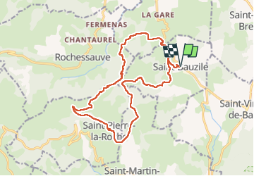
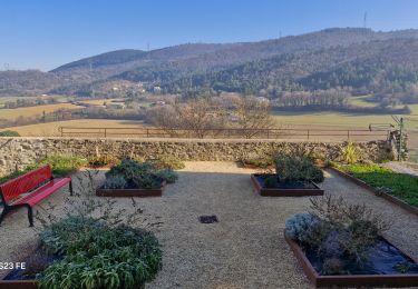
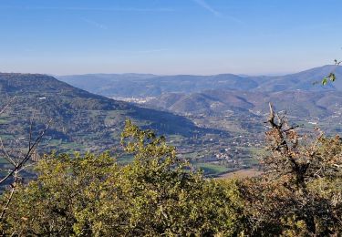
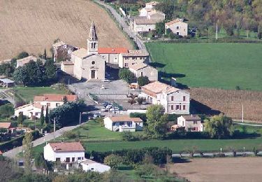
Ruta Senderismo de 18,4 km a descubrir en Auvergne-Rhône-Alpes, Ardecha, Saint-Bauzile. Esta ruta ha sido propuesta por Vero7684.
Descripción
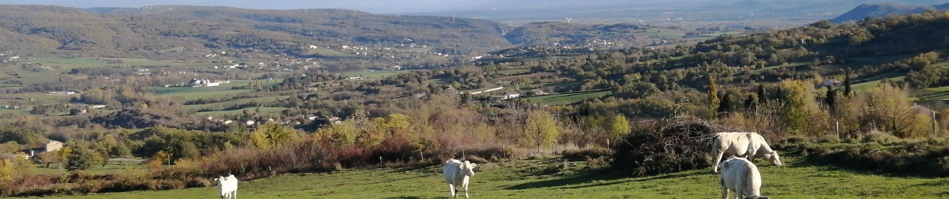
attention le début de la deuxième partie ce fait à vue dans les champs avec 4 passages de clôtures mais paysages superbes et presence de vaches.
Localización
País:
France
Región :
Auvergne-Rhône-Alpes
Departamento/provincia :
Ardecha
Municipio :
Saint-Bauzile
Localidad:
Unknown
Salida:(Dec)
Salida:(UTM)
632684 ; 4948340 (31T) N.
Comentarios
Excursiones cerca
![Excursión Senderismo Saint-Symphorien-sous-Chomérac - St-Symphorien-sous-Chomerac](https://media.geolcdn.com/t/375/260/b69406d1-b9d6-4e5a-81ea-edd2877facfa.jpg&format=jpg&maxdim=2)
![Senderismo Senderismo](https://static1.geolcdn.com/sitytour/trail-icons/101.png)
St-Symphorien-sous-Chomerac "Col de Linte"11km.
Senderismo
Difícil
(2)
Saint-Symphorien-sous-Chomérac,
Auvergne-Rhône-Alpes,
Ardecha,
France
![](/images/other/stat-length.png)
11,4 km | 15,8 km-effort
3h 35min
![](https://static1.geolcdn.com/siteimages/upload/files/16400158638029165_repeat_loop_refresh_sync_direction_icon.png)
Sí
![Excursión Senderismo Saint-Lager-Bressac - 2021-11-20_13h45m12_St Lager Bressac Voie verte 6km.gpx (1).xml - Photo](https://media.geolcdn.com/t/375/260/ext.jpg?maxdim=2&url=https%3A%2F%2Fstatic1.geolcdn.com%2Fsiteimages%2Fupload%2Ffiles%2F1553511878bg_sport_marche.png)
![Senderismo Senderismo](https://static1.geolcdn.com/sitytour/trail-icons/101.png)
2021-11-20_13h45m12_St Lager Bressac Voie verte 6km.gpx (1).xml
Senderismo
Medio
(2)
Saint-Lager-Bressac,
Auvergne-Rhône-Alpes,
Ardecha,
France
![](/images/other/stat-length.png)
5,8 km | 7,4 km-effort
1h 40min
![](https://static1.geolcdn.com/siteimages/upload/files/16400158638029165_repeat_loop_refresh_sync_direction_icon.png)
Sí
![Excursión Senderismo Alissas - 07 Alissas rochessauve zel 23.11.22 - Photo](https://media.geolcdn.com/t/375/260/4287b664-a3fb-4af1-9196-43ecf378ac6d.jpg&format=jpg&maxdim=2)
![Senderismo Senderismo](https://static1.geolcdn.com/sitytour/trail-icons/101.png)
07 Alissas rochessauve zel 23.11.22
Senderismo
Fácil
Alissas,
Auvergne-Rhône-Alpes,
Ardecha,
France
![](/images/other/stat-length.png)
15,3 km | 22 km-effort
6h 5min
![](https://static1.geolcdn.com/siteimages/upload/files/16400158638029165_repeat_loop_refresh_sync_direction_icon.png)
Sí
![Excursión Senderismo Saint-Lager-Bressac - 2021-11-20_13h01m29_St Lager Bressac 6km.xml - Photo](https://media.geolcdn.com/t/375/260/ext.jpg?maxdim=2&url=https%3A%2F%2Fstatic1.geolcdn.com%2Fsiteimages%2Fupload%2Ffiles%2F1553511878bg_sport_marche.png)
![Senderismo Senderismo](https://static1.geolcdn.com/sitytour/trail-icons/101.png)
2021-11-20_13h01m29_St Lager Bressac 6km.xml
Senderismo
Fácil
(1)
Saint-Lager-Bressac,
Auvergne-Rhône-Alpes,
Ardecha,
France
![](/images/other/stat-length.png)
6,7 km | 9,1 km-effort
2h 30min
![](https://static1.geolcdn.com/siteimages/upload/files/16400158638029165_repeat_loop_refresh_sync_direction_icon.png)
Sí
![Excursión Senderismo Rochessauve - 07 rochessauve 14 03 2021 - Photo](https://media.geolcdn.com/t/375/260/7f6e85b3-7daa-46b0-b611-af3c8f642855.jpg&format=jpg&maxdim=2)
![Senderismo Senderismo](https://static1.geolcdn.com/sitytour/trail-icons/101.png)
07 rochessauve 14 03 2021
Senderismo
Fácil
Rochessauve,
Auvergne-Rhône-Alpes,
Ardecha,
France
![](/images/other/stat-length.png)
14,9 km | 22 km-effort
5h 32min
![](https://static1.geolcdn.com/siteimages/upload/files/16400158638029165_repeat_loop_refresh_sync_direction_icon.png)
Sí
![Excursión Senderismo Saint-Vincent-de-Barrès - St-Vincent-de -Barrés](https://media.geolcdn.com/t/375/260/118958f7-515b-4f42-bf38-837d08e40c6a.jpg&format=jpg&maxdim=2)
![Senderismo Senderismo](https://static1.geolcdn.com/sitytour/trail-icons/101.png)
St-Vincent-de -Barrés "Ferme de la Duranne" 10km.
Senderismo
Difícil
Saint-Vincent-de-Barrès,
Auvergne-Rhône-Alpes,
Ardecha,
France
![](/images/other/stat-length.png)
9,9 km | 15,6 km-effort
3h 32min
![](https://static1.geolcdn.com/siteimages/upload/files/16400158638029165_repeat_loop_refresh_sync_direction_icon.png)
Sí
![Excursión Senderismo Saint-Vincent-de-Barrès - 2024-12-20_09h57m45_Vallee_et_Foret_du_Barres - Photo](https://media.geolcdn.com/t/375/260/9cd23095-95c4-48ff-82ff-cfc46d2f1ba3.jpg&format=jpg&maxdim=2)
![Senderismo Senderismo](https://static1.geolcdn.com/sitytour/trail-icons/101.png)
2024-12-20_09h57m45_Vallee_et_Foret_du_Barres
Senderismo
Difícil
Saint-Vincent-de-Barrès,
Auvergne-Rhône-Alpes,
Ardecha,
France
![](/images/other/stat-length.png)
12,3 km | 17 km-effort
3h 51min
![](https://static1.geolcdn.com/siteimages/upload/files/16400158638029165_repeat_loop_refresh_sync_direction_icon.png)
Sí
![Excursión Senderismo Saint-Bauzile - St-Bauzile](https://media.geolcdn.com/t/375/260/347f7f0c-adca-4167-9132-6d76c92a4ffd.jpg&format=jpg&maxdim=2)
![Senderismo Senderismo](https://static1.geolcdn.com/sitytour/trail-icons/101.png)
St-Bauzile"Le Tour du Plateau du Lérou" 13 km.
Senderismo
Difícil
Saint-Bauzile,
Auvergne-Rhône-Alpes,
Ardecha,
France
![](/images/other/stat-length.png)
12,7 km | 18,1 km-effort
4h 7min
![](https://static1.geolcdn.com/siteimages/upload/files/16400158638029165_repeat_loop_refresh_sync_direction_icon.png)
Sí
![Excursión Senderismo Saint-Lager-Bressac - 2024-09-28_21h48m33_13781412 - Photo](https://media.geolcdn.com/t/375/260/3a0457c0-b523-449a-b6c1-c9ebfd766775.jpg&format=jpg&maxdim=2)
![Senderismo Senderismo](https://static1.geolcdn.com/sitytour/trail-icons/101.png)
2024-09-28_21h48m33_13781412
Senderismo
Difícil
(1)
Saint-Lager-Bressac,
Auvergne-Rhône-Alpes,
Ardecha,
France
![](/images/other/stat-length.png)
12,6 km | 18,2 km-effort
4h 8min
![](https://static1.geolcdn.com/siteimages/upload/files/16400158638029165_repeat_loop_refresh_sync_direction_icon.png)
Sí