![](/images/other/stat-length.png)
![Excursión Marcha nórdica Châteauroux-les-Alpes - Le hameau de La reste Châteauroux Guillaine - Photo](https://media.geolcdn.com/t/1900/400/ext.pjpeg?maxdim=2&url=https%3A%2F%2Fstatic1.geolcdn.com%2Fsiteimages%2Fupload%2Ffiles%2F1545311037marcheuse_200dpi.jpg)
Le hameau de La reste Châteauroux Guillaine
damlou
Usuario
![Longitud](/images/other/stat-length.png)
Longitud
7,3 km
![Altitud máxima](https://static1.geolcdn.com/siteimages/upload/files/1508320355ic_sort_altitude_max_24dp.png)
Altitud máxima
1329 m
![Desnivel positivo](https://static1.geolcdn.com/siteimages/upload/files/1508320355ic_sort_den_pos_24dp.png)
Desnivel positivo
353 m
![Km-Effort](/images/other/stat-length.png)
Km-Effort
12 km
![Altitud mínima](https://static1.geolcdn.com/siteimages/upload/files/1508320355ic_sort_altitude_min_24dp.png)
Altitud mínima
973 m
![Desnivel negativo](https://static1.geolcdn.com/siteimages/upload/files/1508320355ic_sort_den_neg_24dp.png)
Desnivel negativo
350 m
![Boucle](https://static1.geolcdn.com/siteimages/upload/files/16400158638029165_repeat_loop_refresh_sync_direction_icon.png)
Boucle
Sí
Fecha de creación :
2022-11-14 08:14:52.59
Última modificación :
2022-11-14 10:58:29.816
![Marcha nórdica](https://static1.geolcdn.com/sitytour/trail-icons/102.png)
1h56
Dificultad : Fácil
![Raquetas de nieve](https://static1.geolcdn.com/sitytour/trail-icons/504.png)
2h00
Dificultad : Medio
![Escanee este código QR para abrir la excursión en la aplicación SityTrail](https://capi.geolives.com/qq0zvz2zws4bq2lad0pu/sitytour/trails/3456668/qr.png?size=200)
Aplicación GPS de excursión GRATIS
A propósito
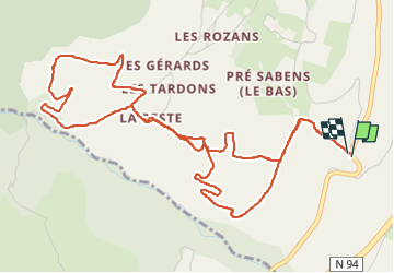
Ruta Marcha nórdica de 7,3 km a descubrir en Provenza-Alpes-Costa Azul, Altos Alpes, Châteauroux-les-Alpes. Esta ruta ha sido propuesta por damlou.
Descripción
Départ parking de la Viste
terrain varie facile
un montée raide sur 100 M.
possibilité d'aller jusqu'au Pinée
Descente couper dans les champs
possibilité raquettes
Localización
País:
France
Región :
Provenza-Alpes-Costa Azul
Departamento/provincia :
Altos Alpes
Municipio :
Châteauroux-les-Alpes
Localidad:
Unknown
Salida:(Dec)
Salida:(UTM)
302993 ; 4941328 (32T) N.
Comentarios
Excursiones cerca
![Excursión Senderismo Saint-André-d'Embrun - mont Aurel - Photo](https://media.geolcdn.com/t/375/260/43268f02-4aa7-403a-bf4c-3a2f3a5ea0ea.jpg&format=jpg&maxdim=2)
![Senderismo Senderismo](https://static1.geolcdn.com/sitytour/trail-icons/101.png)
mont Aurel
Senderismo
Medio
(1)
Saint-André-d'Embrun,
Provenza-Alpes-Costa Azul,
Altos Alpes,
France
![](/images/other/stat-length.png)
8,2 km | 18,4 km-effort
4h 30min
![](https://static1.geolcdn.com/siteimages/upload/files/16400158638029165_repeat_loop_refresh_sync_direction_icon.png)
Sí
![Excursión Senderismo Embrun - Lac de l'Hivernet - Photo](https://media.geolcdn.com/t/375/260/ext.jpg?maxdim=2&url=https%3A%2F%2Fservices.sitytrail.com%2FGeolivesWS%2FDownloadMedia.ashx%3FTrailID%3D1027861%26Media%3Dfix__20180818122123.jpg)
![Senderismo Senderismo](https://static1.geolcdn.com/sitytour/trail-icons/101.png)
Lac de l'Hivernet
Senderismo
Fácil
(1)
Embrun,
Provenza-Alpes-Costa Azul,
Altos Alpes,
France
![](/images/other/stat-length.png)
10,6 km | 21 km-effort
3h 55min
![](https://static1.geolcdn.com/siteimages/upload/files/16400158638029165_repeat_loop_refresh_sync_direction_icon.png)
Sí
![Excursión Senderismo Embrun - Mont Guillaume-Col de Chanté Perdrix-Lac de l'Hivernet(07-09-16) - Photo](https://media.geolcdn.com/t/375/260/ext.jpg?maxdim=2&url=https%3A%2F%2Fservices.sitytrail.com%2FGeolivesWS%2FDownloadMedia.ashx%3FTrailID%3D594349%26Media%3Dfix__20160707110131.jpg)
![Senderismo Senderismo](https://static1.geolcdn.com/sitytour/trail-icons/101.png)
Mont Guillaume-Col de Chanté Perdrix-Lac de l'Hivernet(07-09-16)
Senderismo
Difícil
(2)
Embrun,
Provenza-Alpes-Costa Azul,
Altos Alpes,
France
![](/images/other/stat-length.png)
15,4 km | 31 km-effort
7h 4min
![](https://static1.geolcdn.com/siteimages/upload/files/16400158638029165_repeat_loop_refresh_sync_direction_icon.png)
Sí
![Excursión Senderismo Châteauroux-les-Alpes - boucle cascade de la pisse - Photo](https://media.geolcdn.com/t/375/260/ext.jpg?maxdim=2&url=https%3A%2F%2Fservices.sitytrail.com%2FGeolivesWS%2FDownloadMedia.ashx%3FTrailID%3D455276%26Media%3Dfix__20150806173304.jpg)
![Senderismo Senderismo](https://static1.geolcdn.com/sitytour/trail-icons/101.png)
boucle cascade de la pisse
Senderismo
Muy fácil
(1)
Châteauroux-les-Alpes,
Provenza-Alpes-Costa Azul,
Altos Alpes,
France
![](/images/other/stat-length.png)
8,8 km | 12,4 km-effort
2h 17min
![](https://static1.geolcdn.com/siteimages/upload/files/16400158638029165_repeat_loop_refresh_sync_direction_icon.png)
Sí
![Excursión Senderismo Embrun - Mont Guillaume - Col de Trempa-Latz - 2671 - 10/09/23 - Photo](https://media.geolcdn.com/t/375/260/a1ad9c13-09fc-4e7a-a956-c96541f21c7a.jpg&format=jpg&maxdim=2)
![Senderismo Senderismo](https://static1.geolcdn.com/sitytour/trail-icons/101.png)
Mont Guillaume - Col de Trempa-Latz - 2671 - 10/09/23
Senderismo
Muy difícil
Embrun,
Provenza-Alpes-Costa Azul,
Altos Alpes,
France
![](/images/other/stat-length.png)
13,6 km | 28 km-effort
6h 20min
![](https://static1.geolcdn.com/siteimages/upload/files/16400158638029165_repeat_loop_refresh_sync_direction_icon.png)
Sí
![Excursión Senderismo Embrun - Mont Guillaume - Photo](https://media.geolcdn.com/t/375/260/8a5a6651-8a6c-4528-b5ff-78962c8c835d.jpg&format=jpg&maxdim=2)
![Senderismo Senderismo](https://static1.geolcdn.com/sitytour/trail-icons/101.png)
Mont Guillaume
Senderismo
Difícil
Embrun,
Provenza-Alpes-Costa Azul,
Altos Alpes,
France
![](/images/other/stat-length.png)
12,6 km | 26 km-effort
5h 55min
![](https://static1.geolcdn.com/siteimages/upload/files/16400158638029165_repeat_loop_refresh_sync_direction_icon.png)
Sí
![Excursión Senderismo Embrun - Mt Guillaume - Lac de l'Hivernet - Photo](https://media.geolcdn.com/t/375/260/cbed6be4-74aa-4976-902e-a579816616cf.jpg&format=jpg&maxdim=2)
![Senderismo Senderismo](https://static1.geolcdn.com/sitytour/trail-icons/101.png)
Mt Guillaume - Lac de l'Hivernet
Senderismo
Difícil
Embrun,
Provenza-Alpes-Costa Azul,
Altos Alpes,
France
![](/images/other/stat-length.png)
12,7 km | 28 km-effort
4h 8min
![](https://static1.geolcdn.com/siteimages/upload/files/16400158638029165_repeat_loop_refresh_sync_direction_icon.png)
Sí
![Excursión Senderismo Embrun - lac de l hivernet - Photo](https://media.geolcdn.com/t/375/260/544b0507-fa9b-4776-945d-9f01d5a68a38.jpg&format=jpg&maxdim=2)
![Senderismo Senderismo](https://static1.geolcdn.com/sitytour/trail-icons/101.png)
lac de l hivernet
Senderismo
Fácil
(1)
Embrun,
Provenza-Alpes-Costa Azul,
Altos Alpes,
France
![](/images/other/stat-length.png)
9,4 km | 19,5 km-effort
4h 1min
![](https://static1.geolcdn.com/siteimages/upload/files/16400158638029165_repeat_loop_refresh_sync_direction_icon.png)
Sí
![Excursión Senderismo Embrun - Embrun - 3.4km 90m 1h00 - 2018 06 26 - privé - Photo](https://media.geolcdn.com/t/375/260/ext.jpg?maxdim=2&url=https%3A%2F%2Fservices.sitytrail.com%2FGeolivesWS%2FDownloadMedia.ashx%3FTrailID%3D999315%26Media%3Dfix__20180626102346.jpg)
![Senderismo Senderismo](https://static1.geolcdn.com/sitytour/trail-icons/101.png)
Embrun - 3.4km 90m 1h00 - 2018 06 26 - privé
Senderismo
Muy fácil
Embrun,
Provenza-Alpes-Costa Azul,
Altos Alpes,
France
![](/images/other/stat-length.png)
3,1 km | 4,1 km-effort
1h 15min
![](https://static1.geolcdn.com/siteimages/upload/files/16400158638029165_repeat_loop_refresh_sync_direction_icon.png)
Sí
À découvert pas boisé