![](/images/other/stat-length.png)
![Excursión Villers-la-Ville - 2022-11-14_08h36m25_SityTrail - 3051980 - balade-a-sartxdamesxavelines - Photo](https://media.geolcdn.com/t/1900/400/ext.pjpeg?maxdim=2&url=https%3A%2F%2Fsecurestorage.geolives.com%2Fsitytour%2Ftrail-bg%2Fdefault.jpg)
2022-11-14_08h36m25_SityTrail - 3051980 - balade-a-sartxdamesxavelines
Raymackers
Usuario
![Longitud](/images/other/stat-length.png)
Longitud
8,3 km
![Altitud máxima](https://static1.geolcdn.com/siteimages/upload/files/1508320355ic_sort_altitude_max_24dp.png)
Altitud máxima
153 m
![Desnivel positivo](https://static1.geolcdn.com/siteimages/upload/files/1508320355ic_sort_den_pos_24dp.png)
Desnivel positivo
114 m
![Km-Effort](/images/other/stat-length.png)
Km-Effort
9,8 km
![Altitud mínima](https://static1.geolcdn.com/siteimages/upload/files/1508320355ic_sort_altitude_min_24dp.png)
Altitud mínima
114 m
![Desnivel negativo](https://static1.geolcdn.com/siteimages/upload/files/1508320355ic_sort_den_neg_24dp.png)
Desnivel negativo
114 m
![Boucle](https://static1.geolcdn.com/siteimages/upload/files/16400158638029165_repeat_loop_refresh_sync_direction_icon.png)
Boucle
Sí
Fecha de creación :
2022-11-14 07:36:26.843
Última modificación :
2022-11-14 07:36:28.708
![Escanee este código QR para abrir la excursión en la aplicación SityTrail](https://capi.geolives.com/qq0zvz2zws4bq2lad0pu/sitytour/trails/3456462/qr.png?size=200)
Aplicación GPS de excursión GRATIS
A propósito
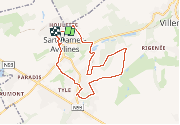
Ruta de 8,3 km a descubrir en Valonia, Brabante Valón, Villers-la-Ville. Esta ruta ha sido propuesta por Raymackers.
Descripción
Jolie balade autour du village de Sart-Dames-Avelines en empruntent une multitude de petits sentiers bien agréable et bien entretenu
Localización
País:
Belgium
Región :
Valonia
Departamento/provincia :
Brabante Valón
Municipio :
Villers-la-Ville
Localidad:
Unknown
Salida:(Dec)
Salida:(UTM)
605664 ; 5602900 (31U) N.
Comentarios
Excursiones cerca
![Excursión Senderismo Villers-la-Ville - RB-Bw-10-raccourci 2 - À travers campagnes et forêts, autour des ruines d’une prestigieuse abbaye - Photo](https://media.geolcdn.com/t/375/260/ext.jpg?maxdim=2&url=https%3A%2F%2Fservices.sitytrail.com%2FGeolivesWS%2FDownloadMedia.ashx%3FTrailID%3D220359%26Media%3Db52f8a40-bd4e-4201-848f-58c9caafd869.jpg)
![Senderismo Senderismo](https://static1.geolcdn.com/sitytour/trail-icons/101.png)
RB-Bw-10-raccourci 2 - À travers campagnes et forêts, autour des ruines d’une...
Senderismo
Difícil
(26)
Villers-la-Ville,
Valonia,
Brabante Valón,
Belgium
![](/images/other/stat-length.png)
13,3 km | 16,4 km-effort
3h 44min
![](https://static1.geolcdn.com/siteimages/upload/files/16400158638029165_repeat_loop_refresh_sync_direction_icon.png)
Sí
![Excursión Senderismo Villers-la-Ville - RB-Bw-10-raccourci 1 - À travers campagnes et forêts, autour des ruines d’une prestigieuse abbaye - Photo](https://media.geolcdn.com/t/375/260/ext.jpg?maxdim=2&url=https%3A%2F%2Fservices.sitytrail.com%2FGeolivesWS%2FDownloadMedia.ashx%3FTrailID%3D220358%26Media%3Db52f8a40-bd4e-4201-848f-58c9caafd869.jpg)
![Senderismo Senderismo](https://static1.geolcdn.com/sitytour/trail-icons/101.png)
RB-Bw-10-raccourci 1 - À travers campagnes et forêts, autour des ruines d’une...
Senderismo
Muy difícil
(13)
Villers-la-Ville,
Valonia,
Brabante Valón,
Belgium
![](/images/other/stat-length.png)
24 km | 30 km-effort
6h 43min
![](https://static1.geolcdn.com/siteimages/upload/files/16400158638029165_repeat_loop_refresh_sync_direction_icon.png)
Sí
![Excursión Senderismo Villers-la-Ville - RB-Bw-10 -À travers campagnes et forêts, autour des ruines d’une prestigieuse abbaye - Photo](https://media.geolcdn.com/t/375/260/ext.jpg?maxdim=2&url=https%3A%2F%2Fservices.sitytrail.com%2FGeolivesWS%2FDownloadMedia.ashx%3FTrailID%3D179585%26Media%3Db52f8a40-bd4e-4201-848f-58c9caafd869.jpg)
![Senderismo Senderismo](https://static1.geolcdn.com/sitytour/trail-icons/101.png)
RB-Bw-10 -À travers campagnes et forêts, autour des ruines d’une prestigieuse...
Senderismo
Muy difícil
(6)
Villers-la-Ville,
Valonia,
Brabante Valón,
Belgium
![](/images/other/stat-length.png)
26 km | 32 km-effort
7h 15min
![](https://static1.geolcdn.com/siteimages/upload/files/16400158638029165_repeat_loop_refresh_sync_direction_icon.png)
Sí
![Excursión Senderismo Genappe - Genappe - Circuit Natura 2000, des sites qui valent le détour ! - Bw03 - Photo](https://media.geolcdn.com/t/375/260/ext.jpg?maxdim=2&url=https%3A%2F%2Fservices.sitytrail.com%2FGeolivesWS%2FDownloadMedia.ashx%3FTrailID%3D356410%26Media%3D9ffde3d0-226c-45a8-b2a5-1fc6dfbe0f90.jpg)
![Senderismo Senderismo](https://static1.geolcdn.com/sitytour/trail-icons/101.png)
Genappe - Circuit Natura 2000, des sites qui valent le détour ! - Bw03
Senderismo
Medio
(6)
Genappe,
Valonia,
Brabante Valón,
Belgium
![](/images/other/stat-length.png)
7,9 km | 9,7 km-effort
2h 6min
![](https://static1.geolcdn.com/siteimages/upload/files/16400158638029165_repeat_loop_refresh_sync_direction_icon.png)
Sí
![Excursión Senderismo Court-Saint-Étienne - GG2-Bw-22_La-Roche-Blanmont_2021-11-04 - Photo](https://media.geolcdn.com/t/375/260/2a6f461f-efef-416e-b536-c468aeb7dc39.jpg&format=jpg&maxdim=2)
![Senderismo Senderismo](https://static1.geolcdn.com/sitytour/trail-icons/101.png)
GG2-Bw-22_La-Roche-Blanmont_2021-11-04
Senderismo
Medio
(2)
Court-Saint-Étienne,
Valonia,
Brabante Valón,
Belgium
![](/images/other/stat-length.png)
21 km | 26 km-effort
5h 51min
![](https://static1.geolcdn.com/siteimages/upload/files/16400158638029165_repeat_loop_refresh_sync_direction_icon.png)
No
![Senderismo Senderismo](https://static1.geolcdn.com/sitytour/trail-icons/101.png)
Bérines
Senderismo
Fácil
(1)
Villers-la-Ville,
Valonia,
Brabante Valón,
Belgium
![](/images/other/stat-length.png)
6,4 km | 7,5 km-effort
1h 41min
![](https://static1.geolcdn.com/siteimages/upload/files/16400158638029165_repeat_loop_refresh_sync_direction_icon.png)
Sí
![Senderismo Senderismo](https://static1.geolcdn.com/sitytour/trail-icons/101.png)
BE-Villers-la-Ville - Le Bois Pigeolet et le Châtelet - VLV 7
Senderismo
Fácil
(1)
Villers-la-Ville,
Valonia,
Brabante Valón,
Belgium
![](/images/other/stat-length.png)
6,6 km | 7,8 km-effort
1h 42min
![](https://static1.geolcdn.com/siteimages/upload/files/16400158638029165_repeat_loop_refresh_sync_direction_icon.png)
Sí
![Excursión Senderismo Villers-la-Ville - Balade forestière à Villers la Ville - Photo](https://media.geolcdn.com/t/375/260/ext.jpg?maxdim=2&url=https%3A%2F%2Fservices.sitytrail.com%2FGeolivesWS%2FDownloadMedia.ashx%3FTrailID%3D120927%26Media%3D124af64a-52e1-4866-a6e4-05b50b4835ef.JPG)
![Senderismo Senderismo](https://static1.geolcdn.com/sitytour/trail-icons/101.png)
Balade forestière à Villers la Ville
Senderismo
Fácil
(5)
Villers-la-Ville,
Valonia,
Brabante Valón,
Belgium
![](/images/other/stat-length.png)
11,5 km | 14,1 km-effort
3h 0min
![](https://static1.geolcdn.com/siteimages/upload/files/16400158638029165_repeat_loop_refresh_sync_direction_icon.png)
Sí
![Excursión Senderismo Court-Saint-Étienne - #240304 - La Roche, bois Ste Catherine et du Sartage - Photo](https://media.geolcdn.com/t/375/260/d185017a-b96f-406a-b9d2-c4084024f2c7.jpg&format=jpg&maxdim=2)
![Senderismo Senderismo](https://static1.geolcdn.com/sitytour/trail-icons/101.png)
#240304 - La Roche, bois Ste Catherine et du Sartage
Senderismo
Medio
(1)
Court-Saint-Étienne,
Valonia,
Brabante Valón,
Belgium
![](/images/other/stat-length.png)
5,8 km | 7,6 km-effort
1h 42min
![](https://static1.geolcdn.com/siteimages/upload/files/16400158638029165_repeat_loop_refresh_sync_direction_icon.png)
Sí