![](/images/other/stat-length.png)
![Excursión Senderismo Landudec - LANDUDEC - Photo](https://media.geolcdn.com/t/1900/400/329e8fe3-24e9-41b2-9559-817c3ad1b334.jpg&format=pjpeg&maxdim=2)
LANDUDEC
RonanDAGORN
Usuario
![Longitud](/images/other/stat-length.png)
Longitud
22 km
![Altitud máxima](https://static1.geolcdn.com/siteimages/upload/files/1508320355ic_sort_altitude_max_24dp.png)
Altitud máxima
124 m
![Desnivel positivo](https://static1.geolcdn.com/siteimages/upload/files/1508320355ic_sort_den_pos_24dp.png)
Desnivel positivo
290 m
![Km-Effort](/images/other/stat-length.png)
Km-Effort
26 km
![Altitud mínima](https://static1.geolcdn.com/siteimages/upload/files/1508320355ic_sort_altitude_min_24dp.png)
Altitud mínima
51 m
![Desnivel negativo](https://static1.geolcdn.com/siteimages/upload/files/1508320355ic_sort_den_neg_24dp.png)
Desnivel negativo
291 m
![Boucle](https://static1.geolcdn.com/siteimages/upload/files/16400158638029165_repeat_loop_refresh_sync_direction_icon.png)
Boucle
Sí
Fecha de creación :
2022-11-13 08:31:40.617
Última modificación :
2022-11-28 18:23:47.865
![Senderismo](https://static1.geolcdn.com/sitytour/trail-icons/101.png)
5h01
Dificultad : Medio
![Escanee este código QR para abrir la excursión en la aplicación SityTrail](https://capi.geolives.com/qq0zvz2zws4bq2lad0pu/sitytour/trails/3456205/qr.png?size=200)
Aplicación GPS de excursión GRATIS
A propósito
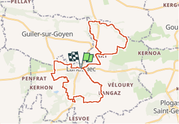
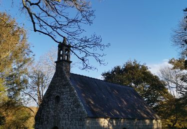
Ruta Senderismo de 22 km a descubrir en Bretaña, Finisterre, Landudec. Esta ruta ha sido propuesta por RonanDAGORN.
Descripción
Randonnée en 8 avec un aller-retour sur une partie mais pas possible de faire autrement en n'utilisant pas de la route
Localización
País:
France
Región :
Bretaña
Departamento/provincia :
Finisterre
Municipio :
Landudec
Localidad:
Unknown
Salida:(Dec)
Salida:(UTM)
400363 ; 5317160 (30T) N.
Comentarios
Excursiones cerca
![Excursión Senderismo Guiler-sur-Goyen - Autour de Guiler-sur-Goyen - Photo](https://media.geolcdn.com/t/375/260/ext.jpg?maxdim=2&url=https%3A%2F%2Fservices.sitytrail.com%2FGeolivesWS%2FDownloadMedia.ashx%3FTrailID%3D172967%26Media%3D14451_4.jpg)
![Senderismo Senderismo](https://static1.geolcdn.com/sitytour/trail-icons/101.png)
Autour de Guiler-sur-Goyen
Senderismo
Difícil
Guiler-sur-Goyen,
Bretaña,
Finisterre,
France
![](/images/other/stat-length.png)
14,9 km | 18 km-effort
3h 45min
![](https://static1.geolcdn.com/siteimages/upload/files/16400158638029165_repeat_loop_refresh_sync_direction_icon.png)
Sí
![Excursión Senderismo Landudec - landudec - Photo](https://media.geolcdn.com/t/375/260/ext.jpg?maxdim=2&url=https%3A%2F%2Fservices.sitytrail.com%2FGeolivesWS%2FDownloadMedia.ashx%3FTrailID%3D171600%26Media%3D20130126153231.jpg)
![Senderismo Senderismo](https://static1.geolcdn.com/sitytour/trail-icons/101.png)
landudec
Senderismo
Muy fácil
Landudec,
Bretaña,
Finisterre,
France
![](/images/other/stat-length.png)
7,8 km | 9,1 km-effort
1h 42min
![](https://static1.geolcdn.com/siteimages/upload/files/16400158638029165_repeat_loop_refresh_sync_direction_icon.png)
Sí
![Excursión Senderismo Landudec - landudec - Photo](https://media.geolcdn.com/t/375/260/435c3596-0016-45e1-8be3-459e3406ad8d.jpg&format=jpg&maxdim=2)
![Senderismo Senderismo](https://static1.geolcdn.com/sitytour/trail-icons/101.png)
landudec
Senderismo
Difícil
Landudec,
Bretaña,
Finisterre,
France
![](/images/other/stat-length.png)
11,1 km | 12,9 km-effort
2h 14min
![](https://static1.geolcdn.com/siteimages/upload/files/16400158638029165_repeat_loop_refresh_sync_direction_icon.png)
Sí
![Excursión Senderismo Plogastel-Saint-Germain - plogastel - Photo](https://media.geolcdn.com/t/375/260/a4a7aa99-2de2-4c28-8bd4-10b110d1e3bd.jpg&format=jpg&maxdim=2)
![Senderismo Senderismo](https://static1.geolcdn.com/sitytour/trail-icons/101.png)
plogastel
Senderismo
Difícil
Plogastel-Saint-Germain,
Bretaña,
Finisterre,
France
![](/images/other/stat-length.png)
12,2 km | 14,1 km-effort
2h 40min
![](https://static1.geolcdn.com/siteimages/upload/files/16400158638029165_repeat_loop_refresh_sync_direction_icon.png)
No
![Excursión Senderismo Plogastel-Saint-Germain - PLOGASTEL SAINT GERMAIN - Photo](https://media.geolcdn.com/t/375/260/ext.jpg?maxdim=2&url=https%3A%2F%2Fservices.sitytrail.com%2FGeolivesWS%2FDownloadMedia.ashx%3FTrailID%3D1123708%26Media%3Dfix__20190317142524.jpg)
![Senderismo Senderismo](https://static1.geolcdn.com/sitytour/trail-icons/101.png)
PLOGASTEL SAINT GERMAIN
Senderismo
Medio
Plogastel-Saint-Germain,
Bretaña,
Finisterre,
France
![](/images/other/stat-length.png)
21 km | 26 km-effort
5h 37min
![](https://static1.geolcdn.com/siteimages/upload/files/16400158638029165_repeat_loop_refresh_sync_direction_icon.png)
Sí
![Excursión Senderismo Landudec - landudec - Photo](https://media.geolcdn.com/t/375/260/e3a315df-ca68-45d9-89e3-679578fa0fcb.jpg&format=jpg&maxdim=2)
![Senderismo Senderismo](https://static1.geolcdn.com/sitytour/trail-icons/101.png)
landudec
Senderismo
Difícil
Landudec,
Bretaña,
Finisterre,
France
![](/images/other/stat-length.png)
10,6 km | 12,3 km-effort
2h 7min
![](https://static1.geolcdn.com/siteimages/upload/files/16400158638029165_repeat_loop_refresh_sync_direction_icon.png)
Sí
![Excursión Senderismo Plozévet - chapelle St ronan - Photo](https://media.geolcdn.com/t/375/260/c8554c97-e8f2-49b0-aa86-63ff95d12ef9.jpg&format=jpg&maxdim=2)
![Senderismo Senderismo](https://static1.geolcdn.com/sitytour/trail-icons/101.png)
chapelle St ronan
Senderismo
Medio
Plozévet,
Bretaña,
Finisterre,
France
![](/images/other/stat-length.png)
10,1 km | 11,5 km-effort
2h 8min
![](https://static1.geolcdn.com/siteimages/upload/files/16400158638029165_repeat_loop_refresh_sync_direction_icon.png)
Sí
![Excursión Senderismo Plogastel-Saint-Germain - les vallées de Plogastel 2h40 11km - Photo](https://media.geolcdn.com/t/375/260/ext.jpg?maxdim=2&url=https%3A%2F%2Fstatic1.geolcdn.com%2Fsiteimages%2Fupload%2Ffiles%2F1553511878bg_sport_marche.png)
![Senderismo Senderismo](https://static1.geolcdn.com/sitytour/trail-icons/101.png)
les vallées de Plogastel 2h40 11km
Senderismo
Muy fácil
Plogastel-Saint-Germain,
Bretaña,
Finisterre,
France
![](/images/other/stat-length.png)
11 km | 13,4 km-effort
Desconocido
![](https://static1.geolcdn.com/siteimages/upload/files/16400158638029165_repeat_loop_refresh_sync_direction_icon.png)
Sí
![Excursión Senderismo Plozévet - Jour n°8 - GRP du Cap-Sizun - Photo](https://media.geolcdn.com/t/375/260/ext.jpg?maxdim=2&url=https%3A%2F%2Fstatic1.geolcdn.com%2Fsiteimages%2Fupload%2Ffiles%2F1553511878bg_sport_marche.png)
![Senderismo Senderismo](https://static1.geolcdn.com/sitytour/trail-icons/101.png)
Jour n°8 - GRP du Cap-Sizun
Senderismo
Plozévet,
Bretaña,
Finisterre,
France
![](/images/other/stat-length.png)
17,1 km | 22 km-effort
4h 59min
![](https://static1.geolcdn.com/siteimages/upload/files/16400158638029165_repeat_loop_refresh_sync_direction_icon.png)
No