![](/images/other/stat-length.png)
![Excursión Senderismo Grandfontaine - 2022-11-12 Marche Grandfontaine Tête Mathis Col de Praye La Corbeille - Photo](https://media.geolcdn.com/t/1900/400/b167e9d9-cb78-437f-9a9a-00585292dbd2.jpg&format=pjpeg&maxdim=2)
2022-11-12 Marche Grandfontaine Tête Mathis Col de Praye La Corbeille
holtzv
Usuario GUIDE
![Longitud](/images/other/stat-length.png)
Longitud
15,3 km
![Altitud máxima](https://static1.geolcdn.com/siteimages/upload/files/1508320355ic_sort_altitude_max_24dp.png)
Altitud máxima
909 m
![Desnivel positivo](https://static1.geolcdn.com/siteimages/upload/files/1508320355ic_sort_den_pos_24dp.png)
Desnivel positivo
605 m
![Km-Effort](/images/other/stat-length.png)
Km-Effort
23 km
![Altitud mínima](https://static1.geolcdn.com/siteimages/upload/files/1508320355ic_sort_altitude_min_24dp.png)
Altitud mínima
610 m
![Desnivel negativo](https://static1.geolcdn.com/siteimages/upload/files/1508320355ic_sort_den_neg_24dp.png)
Desnivel negativo
594 m
![Boucle](https://static1.geolcdn.com/siteimages/upload/files/16400158638029165_repeat_loop_refresh_sync_direction_icon.png)
Boucle
Sí
Fecha de creación :
2022-11-12 10:05:36.765
Última modificación :
2022-11-14 12:15:47.884
![Senderismo](https://static1.geolcdn.com/sitytour/trail-icons/101.png)
4h34
Dificultad : Medio
![Escanee este código QR para abrir la excursión en la aplicación SityTrail](https://capi.geolives.com/qq0zvz2zws4bq2lad0pu/sitytour/trails/3454666/qr.png?size=200)
Aplicación GPS de excursión GRATIS
A propósito
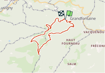
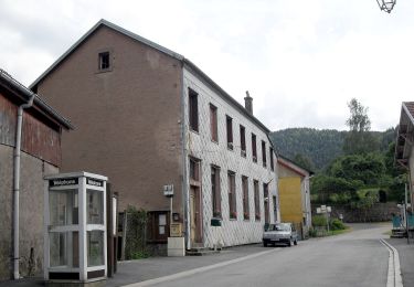
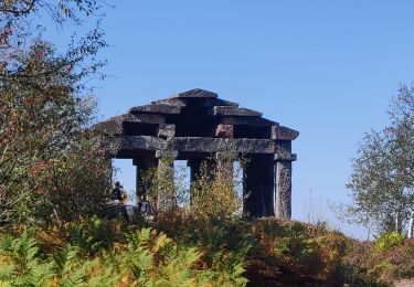
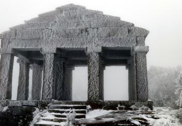
Ruta Senderismo de 15,3 km a descubrir en Gran Este, Bajo-Rin, Grandfontaine. Esta ruta ha sido propuesta por holtzv.
Descripción
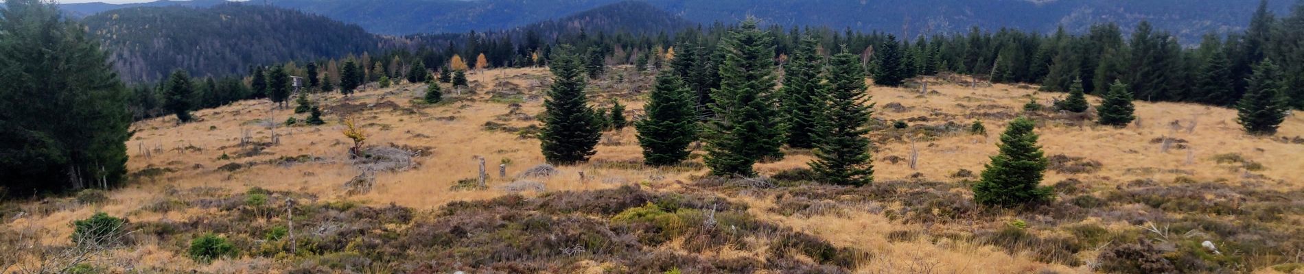
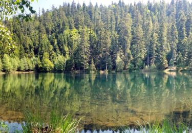
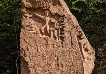
Boucle au départ des Minières derrière Grandfontaine en passant par la Tête Mathis, le col de Prayé, la Tête de Bipierre, la Tête des Roches blanches et les pierres à cupules, et les chaumes de la Corbeille.
Localización
País:
France
Región :
Gran Este
Departamento/provincia :
Bajo-Rin
Municipio :
Grandfontaine
Localidad:
Unknown
Salida:(Dec)
Salida:(UTM)
362667 ; 5372660 (32U) N.
Comentarios
Excursiones cerca
![Excursión Senderismo Grandfontaine - Donon sentier des casemates - sud - Photo](https://media.geolcdn.com/t/375/260/ext.jpg?maxdim=2&url=https%3A%2F%2Fservices.sitytrail.com%2FGeolivesWS%2FDownloadMedia.ashx%3FTrailID%3D425613%26Media%3Dfix__20150525151051.jpg)
![Senderismo Senderismo](https://static1.geolcdn.com/sitytour/trail-icons/101.png)
Donon sentier des casemates - sud
Senderismo
Medio
(1)
Grandfontaine,
Gran Este,
Bajo-Rin,
France
![](/images/other/stat-length.png)
12,6 km | 16,9 km-effort
4h 13min
![](https://static1.geolcdn.com/siteimages/upload/files/16400158638029165_repeat_loop_refresh_sync_direction_icon.png)
Sí
![Excursión Senderismo Grandfontaine - Le site des 2 Donons - Photo](https://media.geolcdn.com/t/375/260/ext.jpg?maxdim=2&url=https%3A%2F%2Fservices.sitytrail.com%2FGeolivesWS%2FDownloadMedia.ashx%3FTrailID%3D201800%26Media%3Db0bd3bee-6dac-4758-b3d3-2df255aa81ea.jpeg)
![Senderismo Senderismo](https://static1.geolcdn.com/sitytour/trail-icons/101.png)
Le site des 2 Donons
Senderismo
Medio
(4)
Grandfontaine,
Gran Este,
Bajo-Rin,
France
![](/images/other/stat-length.png)
12,6 km | 19,4 km-effort
4h 52min
![](https://static1.geolcdn.com/siteimages/upload/files/16400158638029165_repeat_loop_refresh_sync_direction_icon.png)
Sí
![Excursión Senderismo Moussey - Col de Prayé - Photo](https://media.geolcdn.com/t/375/260/ext.jpg?maxdim=2&url=https%3A%2F%2Fservices.sitytrail.com%2FGeolivesWS%2FDownloadMedia.ashx%3FTrailID%3D199313%26Media%3D9ff361be-ea22-414c-86b5-f009d7dbf8c7.jpeg)
![Senderismo Senderismo](https://static1.geolcdn.com/sitytour/trail-icons/101.png)
Col de Prayé
Senderismo
Difícil
(1)
Moussey,
Gran Este,
Vosgos,
France
![](/images/other/stat-length.png)
16,8 km | 23 km-effort
6h 55min
![](https://static1.geolcdn.com/siteimages/upload/files/16400158638029165_repeat_loop_refresh_sync_direction_icon.png)
Sí
![Excursión Senderismo La Broque - 2013-05-18 Marche Ruines de Salm - Photo](https://media.geolcdn.com/t/375/260/ext.jpg?maxdim=2&url=https%3A%2F%2Fstatic1.geolcdn.com%2Fsiteimages%2Fupload%2Ffiles%2F1553511878bg_sport_marche.png)
![Senderismo Senderismo](https://static1.geolcdn.com/sitytour/trail-icons/101.png)
2013-05-18 Marche Ruines de Salm
Senderismo
Muy fácil
(2)
La Broque,
Gran Este,
Bajo-Rin,
France
![](/images/other/stat-length.png)
6,9 km | 10,6 km-effort
2h 38min
![](https://static1.geolcdn.com/siteimages/upload/files/16400158638029165_repeat_loop_refresh_sync_direction_icon.png)
Sí
![Excursión Senderismo Grandfontaine - 2023-05-29 Marche Les Minières Lac de la Maix - Photo](https://media.geolcdn.com/t/375/260/eeaa3a18-ae90-480e-a19f-08ce9b6e70fb.jpg&format=jpg&maxdim=2)
![Senderismo Senderismo](https://static1.geolcdn.com/sitytour/trail-icons/101.png)
2023-05-29 Marche Les Minières Lac de la Maix
Senderismo
Medio
Grandfontaine,
Gran Este,
Bajo-Rin,
France
![](/images/other/stat-length.png)
22 km | 34 km-effort
7h 43min
![](https://static1.geolcdn.com/siteimages/upload/files/16400158638029165_repeat_loop_refresh_sync_direction_icon.png)
Sí
![Excursión Senderismo La Broque - 2023-05-13 Marche Sentier des Passeurs Salm - Photo](https://media.geolcdn.com/t/375/260/5fba6e5d-653d-4695-ac41-35482508dcd1.jpg&format=jpg&maxdim=2)
![Senderismo Senderismo](https://static1.geolcdn.com/sitytour/trail-icons/101.png)
2023-05-13 Marche Sentier des Passeurs Salm
Senderismo
Medio
La Broque,
Gran Este,
Bajo-Rin,
France
![](/images/other/stat-length.png)
25 km | 36 km-effort
7h 49min
![](https://static1.geolcdn.com/siteimages/upload/files/16400158638029165_repeat_loop_refresh_sync_direction_icon.png)
Sí
![Excursión A pie Grandfontaine - Circuit du Chemin d'Allemagne - Photo](https://media.geolcdn.com/t/375/260/d97b757e-2993-4139-a2d2-59b8ba5b2377.jpeg&format=jpg&maxdim=2)
![A pie A pie](https://static1.geolcdn.com/sitytour/trail-icons/100.png)
Circuit du Chemin d'Allemagne
A pie
Fácil
Grandfontaine,
Gran Este,
Bajo-Rin,
France
![](/images/other/stat-length.png)
8,7 km | 13,9 km-effort
3h 10min
![](https://static1.geolcdn.com/siteimages/upload/files/16400158638029165_repeat_loop_refresh_sync_direction_icon.png)
No
![Excursión Senderismo Grandfontaine - 2020-09-20 Marche Donon Petit Donon Casemates - Photo](https://media.geolcdn.com/t/375/260/2db16bda-ff7d-4e64-8ae1-49b9c77c7df1.jpg&format=jpg&maxdim=2)
![Senderismo Senderismo](https://static1.geolcdn.com/sitytour/trail-icons/101.png)
2020-09-20 Marche Donon Petit Donon Casemates
Senderismo
Muy fácil
(1)
Grandfontaine,
Gran Este,
Bajo-Rin,
France
![](/images/other/stat-length.png)
13,4 km | 20 km-effort
4h 17min
![](https://static1.geolcdn.com/siteimages/upload/files/16400158638029165_repeat_loop_refresh_sync_direction_icon.png)
Sí
![Excursión Senderismo Grandfontaine - 2019-01-05 Marche Temple du Donon - Photo](https://media.geolcdn.com/t/375/260/4d10af06-75fc-4752-bbdb-0324344fa64e.jpg&format=jpg&maxdim=2)
![Senderismo Senderismo](https://static1.geolcdn.com/sitytour/trail-icons/101.png)
2019-01-05 Marche Temple du Donon
Senderismo
Medio
Grandfontaine,
Gran Este,
Bajo-Rin,
France
![](/images/other/stat-length.png)
5,6 km | 9,3 km-effort
1h 54min
![](https://static1.geolcdn.com/siteimages/upload/files/16400158638029165_repeat_loop_refresh_sync_direction_icon.png)
Sí