![](/images/other/stat-length.png)
![Excursión Senderismo Pasajes - Pasaia Donibane - Photo](https://media.geolcdn.com/t/1900/400/0553a38d-8a0d-4fa0-800e-ecb893adf7b5.jpg&format=pjpeg&maxdim=2)
Pasaia Donibane
meunier.ph.
Usuario
![Longitud](/images/other/stat-length.png)
Longitud
7,4 km
![Altitud máxima](https://static1.geolcdn.com/siteimages/upload/files/1508320355ic_sort_altitude_max_24dp.png)
Altitud máxima
256 m
![Desnivel positivo](https://static1.geolcdn.com/siteimages/upload/files/1508320355ic_sort_den_pos_24dp.png)
Desnivel positivo
284 m
![Km-Effort](/images/other/stat-length.png)
Km-Effort
11,2 km
![Altitud mínima](https://static1.geolcdn.com/siteimages/upload/files/1508320355ic_sort_altitude_min_24dp.png)
Altitud mínima
-1 m
![Desnivel negativo](https://static1.geolcdn.com/siteimages/upload/files/1508320355ic_sort_den_neg_24dp.png)
Desnivel negativo
286 m
![Boucle](https://static1.geolcdn.com/siteimages/upload/files/16400158638029165_repeat_loop_refresh_sync_direction_icon.png)
Boucle
Sí
Fecha de creación :
2022-11-11 09:49:19.275
Última modificación :
2022-11-11 15:19:30.307
![Senderismo](https://static1.geolcdn.com/sitytour/trail-icons/101.png)
2h20
Dificultad : Medio
![Escanee este código QR para abrir la excursión en la aplicación SityTrail](https://capi.geolives.com/qq0zvz2zws4bq2lad0pu/sitytour/trails/3453460/qr.png?size=200)
Aplicación GPS de excursión GRATIS
A propósito
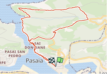
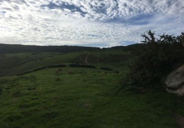
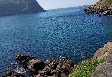
Ruta Senderismo de 7,4 km a descubrir en País Vasco, Guipúzcoa, Pasajes. Esta ruta ha sido propuesta por meunier.ph..
Descripción
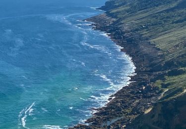
Port actif et charmant. Rando longeant le vieux village de Pasaia Donibane puis remontant la crête le long de rochers aux taffonis de grès sculptés par l'érosion. Vues sur le chenal d'accès au golfe de Gascogne puis sur le large.
Localización
País:
Spain
Región :
País Vasco
Departamento/provincia :
Guipúzcoa
Municipio :
Pasajes
Localidad:
Unknown
Salida:(Dec)
Salida:(UTM)
588075 ; 4797223 (30T) N.
Comentarios
Excursiones cerca
![Excursión A pie San Sebastián - SL-GI 33 Vuelta a Ulía - Photo](https://media.geolcdn.com/t/375/260/27a1f47e-d41e-4539-b0a7-2cf8b0f9bdf1.jpeg&format=jpg&maxdim=2)
![A pie A pie](https://static1.geolcdn.com/sitytour/trail-icons/100.png)
SL-GI 33 Vuelta a Ulía
A pie
Fácil
San Sebastián,
País Vasco,
Guipúzcoa,
Spain
![](/images/other/stat-length.png)
4,9 km | 8,5 km-effort
1h 56min
![](https://static1.geolcdn.com/siteimages/upload/files/16400158638029165_repeat_loop_refresh_sync_direction_icon.png)
Sí
![Senderismo Senderismo](https://static1.geolcdn.com/sitytour/trail-icons/101.png)
littoral Jaizkibel, vallée des couleurs et Paramondras
Senderismo
Muy difícil
Fuenterrabía,
País Vasco,
Guipúzcoa,
Spain
![](/images/other/stat-length.png)
12,8 km | 22 km-effort
5h 6min
![](https://static1.geolcdn.com/siteimages/upload/files/16400158638029165_repeat_loop_refresh_sync_direction_icon.png)
Sí
![Excursión Senderismo Pasajes - Littoral du Jaizkibel I - Photo](https://media.geolcdn.com/t/375/260/c0b73d7c-a983-4f61-bb9e-e7eb6af85a90.jpeg&format=jpg&maxdim=2)
![Senderismo Senderismo](https://static1.geolcdn.com/sitytour/trail-icons/101.png)
Littoral du Jaizkibel I
Senderismo
Muy difícil
Pasajes,
País Vasco,
Guipúzcoa,
Spain
![](/images/other/stat-length.png)
10,3 km | 18,6 km-effort
3h 42min
![](https://static1.geolcdn.com/siteimages/upload/files/16400158638029165_repeat_loop_refresh_sync_direction_icon.png)
Sí
![Excursión Senderismo Pasajes - Piemont du Jaizkibel Pays Basque Espagne - Photo](https://media.geolcdn.com/t/375/260/fd334848-f3d2-471b-86a8-42eac21c68f8.jpg&format=jpg&maxdim=2)
![Senderismo Senderismo](https://static1.geolcdn.com/sitytour/trail-icons/101.png)
Piemont du Jaizkibel Pays Basque Espagne
Senderismo
Muy fácil
Pasajes,
País Vasco,
Guipúzcoa,
Spain
![](/images/other/stat-length.png)
9,8 km | 15,2 km-effort
7h 21min
![](https://static1.geolcdn.com/siteimages/upload/files/16400158638029165_repeat_loop_refresh_sync_direction_icon.png)
Sí
![Excursión Senderismo Pasajes - le batier à la sauce Basque du phiphidechagny - Photo](https://media.geolcdn.com/t/375/260/ext.jpg?maxdim=2&url=https%3A%2F%2Fservices.sitytrail.com%2FGeolivesWS%2FDownloadMedia.ashx%3FTrailID%3D1134598%26Media%3Dfix__20190413165921.jpg)
![Senderismo Senderismo](https://static1.geolcdn.com/sitytour/trail-icons/101.png)
le batier à la sauce Basque du phiphidechagny
Senderismo
Difícil
Pasajes,
País Vasco,
Guipúzcoa,
Spain
![](/images/other/stat-length.png)
25 km | 41 km-effort
7h 35min
![](https://static1.geolcdn.com/siteimages/upload/files/16400158638029165_repeat_loop_refresh_sync_direction_icon.png)
Sí
![Excursión Senderismo Pasajes - le batier à la sauce Basque du phiphidechagny - Photo](https://media.geolcdn.com/t/375/260/ext.jpg?maxdim=2&url=https%3A%2F%2Fservices.sitytrail.com%2FGeolivesWS%2FDownloadMedia.ashx%3FTrailID%3D1134504%26Media%3Dfix__20190413165921.jpg)
![Senderismo Senderismo](https://static1.geolcdn.com/sitytour/trail-icons/101.png)
le batier à la sauce Basque du phiphidechagny
Senderismo
Difícil
Pasajes,
País Vasco,
Guipúzcoa,
Spain
![](/images/other/stat-length.png)
25 km | 41 km-effort
7h 35min
![](https://static1.geolcdn.com/siteimages/upload/files/16400158638029165_repeat_loop_refresh_sync_direction_icon.png)
Sí
![Excursión Senderismo Lezo - Raizkibel depuis Irun avec topo - Photo](https://media.geolcdn.com/t/375/260/7d9a8293-19e8-4036-a96a-024e46e1c78c.jpg&format=jpg&maxdim=2)
![Senderismo Senderismo](https://static1.geolcdn.com/sitytour/trail-icons/101.png)
Raizkibel depuis Irun avec topo
Senderismo
Difícil
Lezo,
País Vasco,
Guipúzcoa,
Spain
![](/images/other/stat-length.png)
16,7 km | 25 km-effort
4h 46min
![](https://static1.geolcdn.com/siteimages/upload/files/16400158638029165_repeat_loop_refresh_sync_direction_icon.png)
No
![Excursión A pie San Sebastián - SL-GI 3 San Marcos - Photo](https://media.geolcdn.com/t/375/260/2fe8878e-9c02-4dc2-97ba-4e40ea438d03.jpeg&format=jpg&maxdim=2)
![A pie A pie](https://static1.geolcdn.com/sitytour/trail-icons/100.png)
SL-GI 3 San Marcos
A pie
Fácil
San Sebastián,
País Vasco,
Guipúzcoa,
Spain
![](/images/other/stat-length.png)
6,6 km | 10 km-effort
2h 16min
![](https://static1.geolcdn.com/siteimages/upload/files/16400158638029165_repeat_loop_refresh_sync_direction_icon.png)
Sí