![](/images/other/stat-length.png)
![Excursión Senderismo Aiguebelette-le-Lac - Belvédère du Rocher du Corbeau - Photo](https://media.geolcdn.com/t/1900/400/ce4a0898-93e9-4db9-96e7-643f23060884.jpg&format=pjpeg&maxdim=2)
Belvédère du Rocher du Corbeau
GuyVachet
Usuario
![Longitud](/images/other/stat-length.png)
![Altitud máxima](https://static1.geolcdn.com/siteimages/upload/files/1508320355ic_sort_altitude_max_24dp.png)
![Desnivel positivo](https://static1.geolcdn.com/siteimages/upload/files/1508320355ic_sort_den_pos_24dp.png)
![Km-Effort](/images/other/stat-length.png)
![Altitud mínima](https://static1.geolcdn.com/siteimages/upload/files/1508320355ic_sort_altitude_min_24dp.png)
![Desnivel negativo](https://static1.geolcdn.com/siteimages/upload/files/1508320355ic_sort_den_neg_24dp.png)
![Boucle](https://static1.geolcdn.com/siteimages/upload/files/16400158638029165_repeat_loop_refresh_sync_direction_icon.png)
![Senderismo](https://static1.geolcdn.com/sitytour/trail-icons/101.png)
2h07
Dificultad : Difícil
![Escanee este código QR para abrir la excursión en la aplicación SityTrail](https://capi.geolives.com/qq0zvz2zws4bq2lad0pu/sitytour/trails/3444543/qr.png?size=200)
Aplicación GPS de excursión GRATIS
A propósito
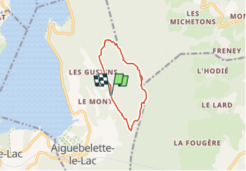
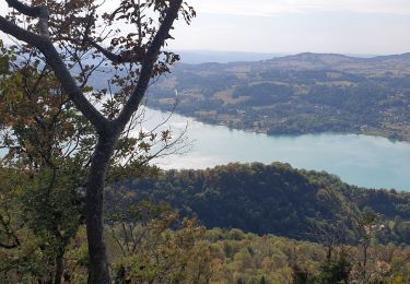
Ruta Senderismo de 5 km a descubrir en Auvergne-Rhône-Alpes, Saboya, Aiguebelette-le-Lac. Esta ruta ha sido propuesta por GuyVachet.
Descripción
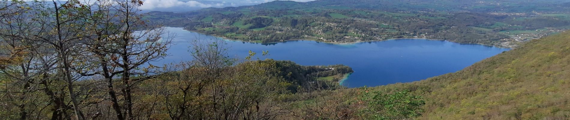
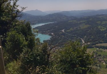
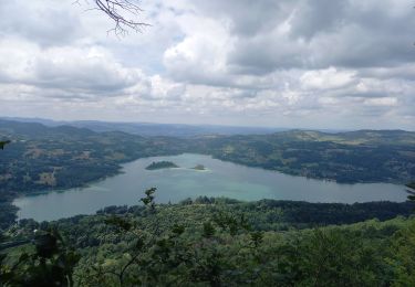
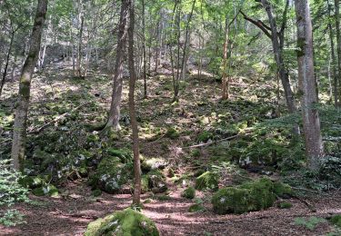
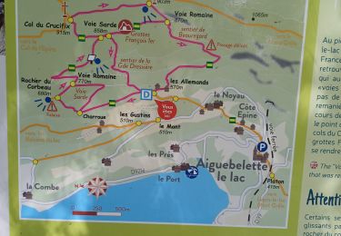
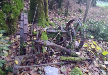
Boucle au-dessus du Lac d'Aiguebelette pour profiter de la vue au Belvédère du Rocher du Corbeau dont la montée finale est difficile et du coup, plutôt que de redescendre, il vaut mieux rejoindre le sentier en trace directe (environ 300m mais l'itinéraire est assez peu marqué). Le parcours permet de passer à la Grotte de François 1er et de là, 2 possibilités : redescendre au parking par l'itinéraire direct (plus rapide) sinon la terminer la boucle mais le sentier est délicat (le panneau l'annonçant ne ment pas).
Localización
Comentarios
Excursiones cerca
![Excursión Ruta La Motte-Servolex - Château Richard et croix du Signal - Photo](https://media.geolcdn.com/t/375/260/3752241f-e62c-4bc8-86ee-aa981979bc96.jpg&format=jpg&maxdim=2)
![Ruta Ruta](https://static1.geolcdn.com/sitytour/trail-icons/104.png)
Ruta
![](/images/other/stat-length.png)
![](https://static1.geolcdn.com/siteimages/upload/files/16400158638029165_repeat_loop_refresh_sync_direction_icon.png)
![Excursión Senderismo Aiguebelette-le-Lac - Mont grêle - Photo](https://media.geolcdn.com/t/375/260/ext.jpg?maxdim=2&url=https%3A%2F%2Fstatic1.geolcdn.com%2Fsiteimages%2Fupload%2Ffiles%2F1553511878bg_sport_marche.png)
![Senderismo Senderismo](https://static1.geolcdn.com/sitytour/trail-icons/101.png)
Senderismo
![](/images/other/stat-length.png)
![](https://static1.geolcdn.com/siteimages/upload/files/16400158638029165_repeat_loop_refresh_sync_direction_icon.png)
![Excursión Senderismo La Motte-Servolex - 73 Croix du signal via Château Renard - Photo](https://media.geolcdn.com/t/375/260/b1ac2841-4f6c-4818-af5e-d71b85094992.jpg&format=jpg&maxdim=2)
![Senderismo Senderismo](https://static1.geolcdn.com/sitytour/trail-icons/101.png)
Senderismo
![](/images/other/stat-length.png)
![](https://static1.geolcdn.com/siteimages/upload/files/16400158638029165_repeat_loop_refresh_sync_direction_icon.png)
![Excursión Senderismo Aiguebelette-le-Lac - 73 aiguebelette zel - Photo](https://media.geolcdn.com/t/375/260/ab86e02e-83d8-47aa-9f9b-0d6ea22ba856.jpg&format=jpg&maxdim=2)
![Senderismo Senderismo](https://static1.geolcdn.com/sitytour/trail-icons/101.png)
Senderismo
![](/images/other/stat-length.png)
![](https://static1.geolcdn.com/siteimages/upload/files/16400158638029165_repeat_loop_refresh_sync_direction_icon.png)
![Excursión Senderismo Aiguebelette-le-Lac - Montagne de l'Epine 2.6.24 - Photo](https://media.geolcdn.com/t/375/260/58f813b2-778e-45f5-aeaf-4a7a3dba23b4.jpg&format=jpg&maxdim=2)
![Senderismo Senderismo](https://static1.geolcdn.com/sitytour/trail-icons/101.png)
Senderismo
![](/images/other/stat-length.png)
![](https://static1.geolcdn.com/siteimages/upload/files/16400158638029165_repeat_loop_refresh_sync_direction_icon.png)
![Excursión Senderismo Aiguebelette-le-Lac - Mont Grêle - Photo](https://media.geolcdn.com/t/375/260/4dc3a178-8cfd-47eb-bb85-9b4370a887ab.jpg&format=jpg&maxdim=2)
![Senderismo Senderismo](https://static1.geolcdn.com/sitytour/trail-icons/101.png)
Senderismo
![](/images/other/stat-length.png)
![](https://static1.geolcdn.com/siteimages/upload/files/16400158638029165_repeat_loop_refresh_sync_direction_icon.png)
![Excursión Senderismo Saint-Sulpice - st Sulpice - croix de crucifix - Aiguebelette - Photo](https://media.geolcdn.com/t/375/260/6f4855e6-ef2a-4072-968f-26eff92ed454.jpg&format=jpg&maxdim=2)
![Senderismo Senderismo](https://static1.geolcdn.com/sitytour/trail-icons/101.png)
Senderismo
![](/images/other/stat-length.png)
![](https://static1.geolcdn.com/siteimages/upload/files/16400158638029165_repeat_loop_refresh_sync_direction_icon.png)
![Excursión Senderismo Nances - ballade vers Nances - Photo](https://media.geolcdn.com/t/375/260/08823fc1-7084-40fb-98e3-3a7cfdd25397.jpg&format=jpg&maxdim=2)
![Senderismo Senderismo](https://static1.geolcdn.com/sitytour/trail-icons/101.png)
Senderismo
![](/images/other/stat-length.png)
![](https://static1.geolcdn.com/siteimages/upload/files/16400158638029165_repeat_loop_refresh_sync_direction_icon.png)
![Excursión Senderismo Aiguebelette-le-Lac - aiguebelette, col du crucifix - Photo](https://media.geolcdn.com/t/375/260/3975328f-8c52-4ec0-b838-5ee346944eab.jpg&format=jpg&maxdim=2)
![Senderismo Senderismo](https://static1.geolcdn.com/sitytour/trail-icons/101.png)
Senderismo
![](/images/other/stat-length.png)
![](https://static1.geolcdn.com/siteimages/upload/files/16400158638029165_repeat_loop_refresh_sync_direction_icon.png)