![](/images/other/stat-length.png)
![Excursión Senderismo Collobrières - collobrieres, Lambert, laquina - Photo](https://media.geolcdn.com/t/1900/400/78d47aeb-6feb-431a-8d9c-c509cc4e583c.jpg&format=pjpeg&maxdim=2)
collobrieres, Lambert, laquina
cdanielrando
Usuario
![Longitud](/images/other/stat-length.png)
![Altitud máxima](https://static1.geolcdn.com/siteimages/upload/files/1508320355ic_sort_altitude_max_24dp.png)
![Desnivel positivo](https://static1.geolcdn.com/siteimages/upload/files/1508320355ic_sort_den_pos_24dp.png)
![Km-Effort](/images/other/stat-length.png)
![Altitud mínima](https://static1.geolcdn.com/siteimages/upload/files/1508320355ic_sort_altitude_min_24dp.png)
![Desnivel negativo](https://static1.geolcdn.com/siteimages/upload/files/1508320355ic_sort_den_neg_24dp.png)
![Boucle](https://static1.geolcdn.com/siteimages/upload/files/16400158638029165_repeat_loop_refresh_sync_direction_icon.png)
![Senderismo](https://static1.geolcdn.com/sitytour/trail-icons/101.png)
6h31
Dificultad : Medio
![Escanee este código QR para abrir la excursión en la aplicación SityTrail](https://capi.geolives.com/qq0zvz2zws4bq2lad0pu/sitytour/trails/3444541/qr.png?size=200)
Aplicación GPS de excursión GRATIS
A propósito
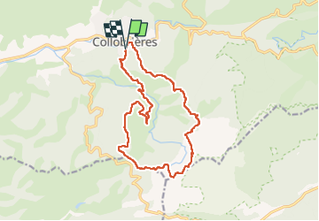
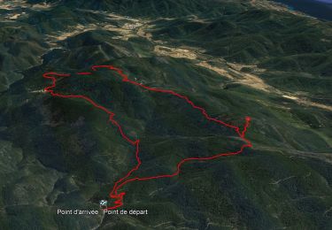
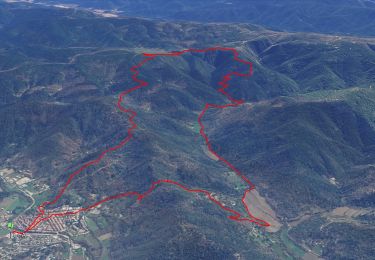
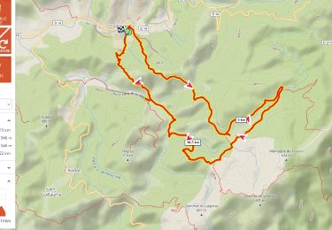
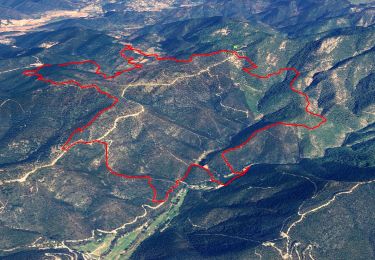
Ruta Senderismo de 16,9 km a descubrir en Provenza-Alpes-Costa Azul, Var, Collobrières. Esta ruta ha sido propuesta por cdanielrando.
Descripción
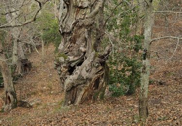
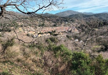
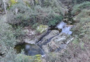
Du pk au cimetière, traverser le village pour rejoindre le Gr 90 qui vous conduit , en montée jusqu'au plateau Lambert. Les deux menhirs bien visibles sont dans une prairie clôturée. Continuer sur le Gr et le quitter avant d'arriver au sommet du Laquina. Vue mer imprenable. Prendre à droite sur la dfci en direction du col du Babaou. Du sommet de Pertuade en direction de la Malière, bien suivre le tracé car le sentier non balisé est moins visible. Passé le gué de la haute Malière, le sentier en balcon monte avant de redescendre au pk
Localización
Comentarios
Excursiones cerca
![Excursión Senderismo Collobrières - 10881733-Collobrières - La Verne - radar - Photo](https://media.geolcdn.com/t/375/260/da9d634a-9911-4550-a6f3-bff27c212c6d.jpg&format=jpg&maxdim=2)
![Senderismo Senderismo](https://static1.geolcdn.com/sitytour/trail-icons/101.png)
Senderismo
![](/images/other/stat-length.png)
![](https://static1.geolcdn.com/siteimages/upload/files/16400158638029165_repeat_loop_refresh_sync_direction_icon.png)
![Excursión Senderismo Collobrières - SityTrail - Collobriéres - Menhirs de Lambert - Photo](https://media.geolcdn.com/t/375/260/72b69c29-7d29-4189-adbb-316e95f51f98.jpg&format=jpg&maxdim=2)
![Senderismo Senderismo](https://static1.geolcdn.com/sitytour/trail-icons/101.png)
Senderismo
![](/images/other/stat-length.png)
![](https://static1.geolcdn.com/siteimages/upload/files/16400158638029165_repeat_loop_refresh_sync_direction_icon.png)
![Excursión Bici de montaña Collobrières - Collobrières par pistes - Photo](https://media.geolcdn.com/t/375/260/ext.jpg?maxdim=2&url=https%3A%2F%2Fstatic1.geolcdn.com%2Fsiteimages%2Fupload%2Ffiles%2F1524743154velo.jpg)
![Bici de montaña Bici de montaña](https://static1.geolcdn.com/sitytour/trail-icons/202.png)
Bici de montaña
![](/images/other/stat-length.png)
![](https://static1.geolcdn.com/siteimages/upload/files/16400158638029165_repeat_loop_refresh_sync_direction_icon.png)
![Excursión Senderismo Collobrières - Plateau Lambert 2 - Photo](https://media.geolcdn.com/t/375/260/ext.jpg?maxdim=2&url=https%3A%2F%2Fstatic1.geolcdn.com%2Fsiteimages%2Fupload%2Ffiles%2F1553511878bg_sport_marche.png)
![Senderismo Senderismo](https://static1.geolcdn.com/sitytour/trail-icons/101.png)
Senderismo
![](/images/other/stat-length.png)
![](https://static1.geolcdn.com/siteimages/upload/files/16400158638029165_repeat_loop_refresh_sync_direction_icon.png)
![Excursión Senderismo Collobrières - Verne - plateau Lambert - Photo](https://media.geolcdn.com/t/375/260/c4a3a8a8-b423-4008-8407-4394445c8024.jpg&format=jpg&maxdim=2)
![Senderismo Senderismo](https://static1.geolcdn.com/sitytour/trail-icons/101.png)
Senderismo
![](/images/other/stat-length.png)
![](https://static1.geolcdn.com/siteimages/upload/files/16400158638029165_repeat_loop_refresh_sync_direction_icon.png)
![Excursión Senderismo Collobrières - plateau Lambert en partant de Collobrieres - Photo](https://media.geolcdn.com/t/375/260/0201a1ab-7db2-4574-9d4b-cd6077f68d1f.png&format=jpg&maxdim=2)
![Senderismo Senderismo](https://static1.geolcdn.com/sitytour/trail-icons/101.png)
Senderismo
![](/images/other/stat-length.png)
![](https://static1.geolcdn.com/siteimages/upload/files/16400158638029165_repeat_loop_refresh_sync_direction_icon.png)
![Excursión Senderismo Collobrières - Les Maures-Collobrières-15-03-23 - Photo](https://media.geolcdn.com/t/375/260/17405386-717a-4f1d-adef-f081e285d037.jpg&format=jpg&maxdim=2)
![Senderismo Senderismo](https://static1.geolcdn.com/sitytour/trail-icons/101.png)
Senderismo
![](/images/other/stat-length.png)
![](https://static1.geolcdn.com/siteimages/upload/files/16400158638029165_repeat_loop_refresh_sync_direction_icon.png)
![Excursión Senderismo Collobrières - SityTrail - chapelle st guillaume - Photo](https://media.geolcdn.com/t/375/260/c6bacdd0-ee98-427d-aed4-896ac2a549a6.jpg&format=jpg&maxdim=2)
![Senderismo Senderismo](https://static1.geolcdn.com/sitytour/trail-icons/101.png)
Senderismo
![](/images/other/stat-length.png)
![](https://static1.geolcdn.com/siteimages/upload/files/16400158638029165_repeat_loop_refresh_sync_direction_icon.png)
![Excursión Senderismo Collobrières - La Verne - Cèdres de Ragusse by DAL - Photo](https://media.geolcdn.com/t/375/260/f7e1e88a-2b2e-4882-9eac-d0eeb8081eba.jpg&format=jpg&maxdim=2)
![Senderismo Senderismo](https://static1.geolcdn.com/sitytour/trail-icons/101.png)
Senderismo
![](/images/other/stat-length.png)
![](https://static1.geolcdn.com/siteimages/upload/files/16400158638029165_repeat_loop_refresh_sync_direction_icon.png)