![](/images/other/stat-length.png)
![Excursión Senderismo Breil-sur-Roya - Circuit Libre , Breil sur Roya - Photo](https://media.geolcdn.com/t/1900/400/ceb351f5-9102-48c3-81fd-8ae3bb85ee14.jpg&format=pjpeg&maxdim=2)
Circuit Libre , Breil sur Roya
GrouGary
Usuario
![Longitud](/images/other/stat-length.png)
![Altitud máxima](https://static1.geolcdn.com/siteimages/upload/files/1508320355ic_sort_altitude_max_24dp.png)
![Desnivel positivo](https://static1.geolcdn.com/siteimages/upload/files/1508320355ic_sort_den_pos_24dp.png)
![Km-Effort](/images/other/stat-length.png)
![Altitud mínima](https://static1.geolcdn.com/siteimages/upload/files/1508320355ic_sort_altitude_min_24dp.png)
![Desnivel negativo](https://static1.geolcdn.com/siteimages/upload/files/1508320355ic_sort_den_neg_24dp.png)
![Boucle](https://static1.geolcdn.com/siteimages/upload/files/16400158638029165_repeat_loop_refresh_sync_direction_icon.png)
![Senderismo](https://static1.geolcdn.com/sitytour/trail-icons/101.png)
4h05
Dificultad : Medio
![Escanee este código QR para abrir la excursión en la aplicación SityTrail](https://capi.geolives.com/qq0zvz2zws4bq2lad0pu/sitytour/trails/3433676/qr.png?size=200)
Aplicación GPS de excursión GRATIS
A propósito
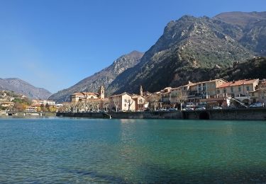
Ruta Senderismo de 10,6 km a descubrir en Provenza-Alpes-Costa Azul, Alpes Marítimos, Breil-sur-Roya. Esta ruta ha sido propuesta por GrouGary.
Descripción
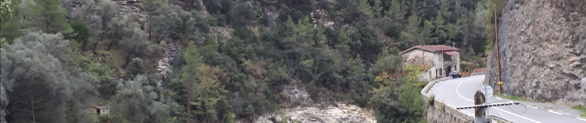
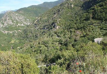
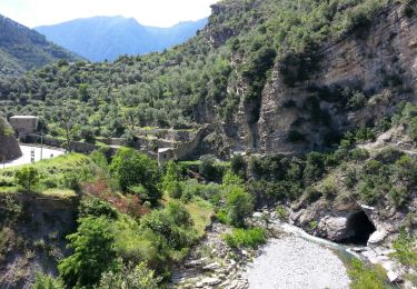
Libre, rattaché à la France en 1947, n’est accessible que par une route assez étroite et sinueuse (12 lacets superposés), enclavée entre les douanes française et italienne.
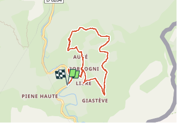
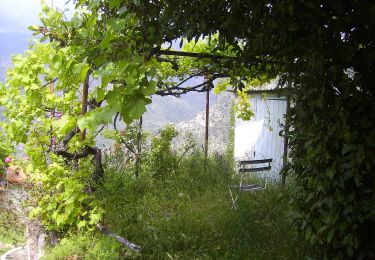
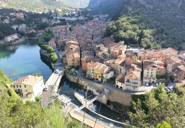
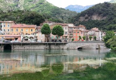
Démarrage de la rando de la route principale de Breil/Roya qui longe la Roya, sur une bande courte ne laissant place que pour 2 à 3 voitures. La montée vers Libre se fait sur des anciennes oliveraies et un ancien moulin à huile. Ce qui ajoute environ 300 m au circuit classique de "Randoxygène". Le dénivelé total sera de 800 pour 11 km. Il s'agit donc d'une randonnée sans difficulté technique mais avec une régularité dans la montée/descente sur une courte distance parcourue.
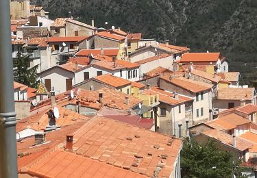
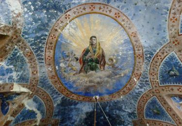
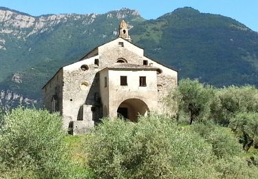
Ce circuit facile, sur les anciens chemins de desserte agricole, permettra de côtoyer les divers quartiers de Libre (Libre, Cotté, Aubé, Bourgogni) et d’y découvrir quelques architectures originales aux volumes et aux coloris d’inspiration mauresque.
R : ne pas rater le petit sentier à Aubé (ne pas descendre la route)
Localización
Comentarios
Excursiones cerca
![Excursión A pie Breil-sur-Roya - Circuit de la Carleva - Photo](https://media.geolcdn.com/t/375/260/0627645c-5ecc-4822-ad2e-18748ce8a356.jpeg&format=jpg&maxdim=2)
![A pie A pie](https://static1.geolcdn.com/sitytour/trail-icons/100.png)
A pie
![](/images/other/stat-length.png)
![](https://static1.geolcdn.com/siteimages/upload/files/16400158638029165_repeat_loop_refresh_sync_direction_icon.png)
![Excursión A pie Airole - Traversée Airole-Breil - Photo](https://media.geolcdn.com/t/375/260/62b54dcb-d617-407a-81a2-9f5c93e8261f.jpeg&format=jpg&maxdim=2)
![A pie A pie](https://static1.geolcdn.com/sitytour/trail-icons/100.png)
A pie
![](/images/other/stat-length.png)
![](https://static1.geolcdn.com/siteimages/upload/files/16400158638029165_repeat_loop_refresh_sync_direction_icon.png)
![Excursión A pie Breil-sur-Roya - Circuit de Libre - Photo](https://media.geolcdn.com/t/375/260/dcdab34e-1af6-4915-900a-fc3842fda859.jpeg&format=jpg&maxdim=2)
![A pie A pie](https://static1.geolcdn.com/sitytour/trail-icons/100.png)
A pie
![](/images/other/stat-length.png)
![](https://static1.geolcdn.com/siteimages/upload/files/16400158638029165_repeat_loop_refresh_sync_direction_icon.png)
![Excursión A pie Breil-sur-Roya - Hameau de Piène Haute - Photo](https://media.geolcdn.com/t/375/260/ba7ed6ca-7792-48a5-80e1-bdc0636dfb80.jpeg&format=jpg&maxdim=2)
![A pie A pie](https://static1.geolcdn.com/sitytour/trail-icons/100.png)
A pie
![](/images/other/stat-length.png)
![](https://static1.geolcdn.com/siteimages/upload/files/16400158638029165_repeat_loop_refresh_sync_direction_icon.png)
![Excursión A pie Sospel - Tour du mont Grazian - Photo](https://media.geolcdn.com/t/375/260/1da10739-2e7a-4ef9-ac53-576dd44be28a.jpeg&format=jpg&maxdim=2)
![A pie A pie](https://static1.geolcdn.com/sitytour/trail-icons/100.png)
A pie
![](/images/other/stat-length.png)
![](https://static1.geolcdn.com/siteimages/upload/files/16400158638029165_repeat_loop_refresh_sync_direction_icon.png)
![Excursión Senderismo Breil-sur-Roya - Breil-sur-Roya - Notre-Dame du Mont - 2016 06 21 - Photo](https://media.geolcdn.com/t/375/260/ext.jpg?maxdim=2&url=https%3A%2F%2Fservices.sitytrail.com%2FGeolivesWS%2FDownloadMedia.ashx%3FTrailID%3D598710%26Media%3Dfix__20160621171358.jpg)
![Senderismo Senderismo](https://static1.geolcdn.com/sitytour/trail-icons/101.png)
Senderismo
![](/images/other/stat-length.png)
![](https://static1.geolcdn.com/siteimages/upload/files/16400158638029165_repeat_loop_refresh_sync_direction_icon.png)
![Excursión Senderismo Breil-sur-Roya - Breil-sur-Roya - Piène Haute - Piène Basse - Libre - 2016 06 25 - 1160m 18,5km - Photo](https://media.geolcdn.com/t/375/260/ext.jpg?maxdim=2&url=https%3A%2F%2Fservices.sitytrail.com%2FGeolivesWS%2FDownloadMedia.ashx%3FTrailID%3D598703%26Media%3Dfix__20160625083158.jpg)
![Senderismo Senderismo](https://static1.geolcdn.com/sitytour/trail-icons/101.png)
Senderismo
![](/images/other/stat-length.png)
![](https://static1.geolcdn.com/siteimages/upload/files/16400158638029165_repeat_loop_refresh_sync_direction_icon.png)
![Excursión Senderismo Breil-sur-Roya - Breil-sur-Roya - 2016 06 19 - Photo](https://media.geolcdn.com/t/375/260/ext.jpg?maxdim=2&url=https%3A%2F%2Fservices.sitytrail.com%2FGeolivesWS%2FDownloadMedia.ashx%3FTrailID%3D598701%26Media%3Dfix__20160619144915.jpg)
![Senderismo Senderismo](https://static1.geolcdn.com/sitytour/trail-icons/101.png)
Senderismo
![](/images/other/stat-length.png)
![](https://static1.geolcdn.com/siteimages/upload/files/16400158638029165_repeat_loop_refresh_sync_direction_icon.png)
![Excursión Senderismo Breil-sur-Roya - Breil-sur-Roya - Sentier Valéen Sud - 2016 06 21 - Photo](https://media.geolcdn.com/t/375/260/ext.jpg?maxdim=2&url=https%3A%2F%2Fservices.sitytrail.com%2FGeolivesWS%2FDownloadMedia.ashx%3FTrailID%3D598699%26Media%3Dfix__20160621154716.jpg)
![Senderismo Senderismo](https://static1.geolcdn.com/sitytour/trail-icons/101.png)
Senderismo
![](/images/other/stat-length.png)
![](https://static1.geolcdn.com/siteimages/upload/files/16400158638029165_repeat_loop_refresh_sync_direction_icon.png)