![](/images/other/stat-length.png)
![Excursión Senderismo Lus-la-Croix-Haute - LA CAIRE-COMMANDERIE TOUSSIERE (PETIT CIRCUIT) - Photo](https://media.geolcdn.com/t/1900/400/ext.pjpeg?maxdim=2&url=https%3A%2F%2Fstatic1.geolcdn.com%2Fsiteimages%2Fupload%2Ffiles%2F1553511878bg_sport_marche.png)
LA CAIRE-COMMANDERIE TOUSSIERE (PETIT CIRCUIT)
RD78-38
Usuario
![Longitud](/images/other/stat-length.png)
Longitud
7,7 km
![Altitud máxima](https://static1.geolcdn.com/siteimages/upload/files/1508320355ic_sort_altitude_max_24dp.png)
Altitud máxima
1277 m
![Desnivel positivo](https://static1.geolcdn.com/siteimages/upload/files/1508320355ic_sort_den_pos_24dp.png)
Desnivel positivo
313 m
![Km-Effort](/images/other/stat-length.png)
Km-Effort
11,9 km
![Altitud mínima](https://static1.geolcdn.com/siteimages/upload/files/1508320355ic_sort_altitude_min_24dp.png)
Altitud mínima
998 m
![Desnivel negativo](https://static1.geolcdn.com/siteimages/upload/files/1508320355ic_sort_den_neg_24dp.png)
Desnivel negativo
310 m
![Boucle](https://static1.geolcdn.com/siteimages/upload/files/16400158638029165_repeat_loop_refresh_sync_direction_icon.png)
Boucle
Sí
Fecha de creación :
2014-12-10 00:00:00.0
Última modificación :
2020-07-11 00:25:11.12
![Senderismo](https://static1.geolcdn.com/sitytour/trail-icons/101.png)
2h44
Dificultad : Fácil
![Escanee este código QR para abrir la excursión en la aplicación SityTrail](https://capi.geolives.com/qq0zvz2zws4bq2lad0pu/sitytour/trails/343199/qr.png?size=200)
Aplicación GPS de excursión GRATIS
A propósito
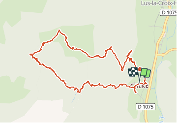
Ruta Senderismo de 7,7 km a descubrir en Auvergne-Rhône-Alpes, Drôme, Lus-la-Croix-Haute. Esta ruta ha sido propuesta por RD78-38.
Descripción
Petit circuit facile sans grand intérêt : circuit pratiquement toujours en forêt sans aucune vue.
Localización
País:
France
Región :
Auvergne-Rhône-Alpes
Departamento/provincia :
Drôme
Municipio :
Lus-la-Croix-Haute
Localidad:
Unknown
Salida:(Dec)
Salida:(UTM)
713479 ; 4948718 (31T) N.
Comentarios
Excursiones cerca
![Excursión Senderismo Glandage - Le Jocou 2 - Photo](https://media.geolcdn.com/t/375/260/3db953da-6976-42b8-b004-e2f45e4d2956.jpg&format=jpg&maxdim=2)
![Senderismo Senderismo](https://static1.geolcdn.com/sitytour/trail-icons/101.png)
Le Jocou 2
Senderismo
Difícil
Glandage,
Auvergne-Rhône-Alpes,
Drôme,
France
![](/images/other/stat-length.png)
8,5 km | 18,1 km-effort
4h 0min
![](https://static1.geolcdn.com/siteimages/upload/files/16400158638029165_repeat_loop_refresh_sync_direction_icon.png)
Sí
![Excursión Senderismo Lus-la-Croix-Haute - Pointe Feuillette - Photo](https://media.geolcdn.com/t/375/260/c32e652d-9142-443d-9f13-87284c6d10a4.jpg&format=jpg&maxdim=2)
![Senderismo Senderismo](https://static1.geolcdn.com/sitytour/trail-icons/101.png)
Pointe Feuillette
Senderismo
Difícil
Lus-la-Croix-Haute,
Auvergne-Rhône-Alpes,
Drôme,
France
![](/images/other/stat-length.png)
10,5 km | 20 km-effort
4h 36min
![](https://static1.geolcdn.com/siteimages/upload/files/16400158638029165_repeat_loop_refresh_sync_direction_icon.png)
Sí
![Excursión Senderismo Glandage - 2022-09-05_12h23m25_Le Jocou-col de Seysse 12km.gpx (2).xml - Photo](https://media.geolcdn.com/t/375/260/7fa8e50f-0ae3-4fbb-b69e-805ffe4b1242.jpg&format=jpg&maxdim=2)
![Senderismo Senderismo](https://static1.geolcdn.com/sitytour/trail-icons/101.png)
2022-09-05_12h23m25_Le Jocou-col de Seysse 12km.gpx (2).xml
Senderismo
Muy difícil
Glandage,
Auvergne-Rhône-Alpes,
Drôme,
France
![](/images/other/stat-length.png)
11,6 km | 24 km-effort
5h 27min
![](https://static1.geolcdn.com/siteimages/upload/files/16400158638029165_repeat_loop_refresh_sync_direction_icon.png)
Sí
![Excursión Senderismo Glandage - 2022-06-24_19h10m37_Le Jocou par crêtes des Amousières 10km.gpx.xml - Photo](https://media.geolcdn.com/t/375/260/eeeff28a-8806-426d-aef8-2ba384b53865.jpg&format=jpg&maxdim=2)
![Senderismo Senderismo](https://static1.geolcdn.com/sitytour/trail-icons/101.png)
2022-06-24_19h10m37_Le Jocou par crêtes des Amousières 10km.gpx.xml
Senderismo
Muy difícil
Glandage,
Auvergne-Rhône-Alpes,
Drôme,
France
![](/images/other/stat-length.png)
9,6 km | 22 km-effort
5h 9min
![](https://static1.geolcdn.com/siteimages/upload/files/16400158638029165_repeat_loop_refresh_sync_direction_icon.png)
Sí
![Excursión Senderismo Glandage - Grimone-Le Jocou 12km - Photo](https://media.geolcdn.com/t/375/260/cd25f2bd-a51d-4184-be3b-7961b829b3e2.jpg&format=jpg&maxdim=2)
![Senderismo Senderismo](https://static1.geolcdn.com/sitytour/trail-icons/101.png)
Grimone-Le Jocou 12km
Senderismo
Difícil
Glandage,
Auvergne-Rhône-Alpes,
Drôme,
France
![](/images/other/stat-length.png)
12 km | 24 km-effort
6h 0min
![](https://static1.geolcdn.com/siteimages/upload/files/16400158638029165_repeat_loop_refresh_sync_direction_icon.png)
Sí
![Excursión Senderismo Lus-la-Croix-Haute - R48 - Gorges des Amayères - Photo](https://media.geolcdn.com/t/375/260/4bbc825f-a565-4275-9665-85da99118f1b.jpg&format=jpg&maxdim=2)
![Senderismo Senderismo](https://static1.geolcdn.com/sitytour/trail-icons/101.png)
R48 - Gorges des Amayères
Senderismo
Fácil
Lus-la-Croix-Haute,
Auvergne-Rhône-Alpes,
Drôme,
France
![](/images/other/stat-length.png)
10,3 km | 17,5 km-effort
3h 1min
![](https://static1.geolcdn.com/siteimages/upload/files/16400158638029165_repeat_loop_refresh_sync_direction_icon.png)
No
![Excursión Senderismo Lus-la-Croix-Haute - Le Rognon - Photo](https://media.geolcdn.com/t/375/260/ext.jpg?maxdim=2&url=https%3A%2F%2Fstatic1.geolcdn.com%2Fsiteimages%2Fupload%2Ffiles%2F1553511878bg_sport_marche.png)
![Senderismo Senderismo](https://static1.geolcdn.com/sitytour/trail-icons/101.png)
Le Rognon
Senderismo
Medio
(1)
Lus-la-Croix-Haute,
Auvergne-Rhône-Alpes,
Drôme,
France
![](/images/other/stat-length.png)
12,3 km | 22 km-effort
4h 33min
![](https://static1.geolcdn.com/siteimages/upload/files/16400158638029165_repeat_loop_refresh_sync_direction_icon.png)
Sí
![Excursión Senderismo Saint-Julien-en-Beauchêne - ST JULIEN EN BEAUCHENE- VAUNIERES - Photo](https://media.geolcdn.com/t/375/260/ext.jpg?maxdim=2&url=https%3A%2F%2Fstatic1.geolcdn.com%2Fsiteimages%2Fupload%2Ffiles%2F1553511878bg_sport_marche.png)
![Senderismo Senderismo](https://static1.geolcdn.com/sitytour/trail-icons/101.png)
ST JULIEN EN BEAUCHENE- VAUNIERES
Senderismo
Medio
(1)
Saint-Julien-en-Beauchêne,
Provenza-Alpes-Costa Azul,
Altos Alpes,
France
![](/images/other/stat-length.png)
9,4 km | 18,4 km-effort
3h 59min
![](https://static1.geolcdn.com/siteimages/upload/files/16400158638029165_repeat_loop_refresh_sync_direction_icon.png)
No
![A pie A pie](https://static1.geolcdn.com/sitytour/trail-icons/100.png)
2024-04-17_Au fil du Buech
A pie
Fácil
Lus-la-Croix-Haute,
Auvergne-Rhône-Alpes,
Drôme,
France
![](/images/other/stat-length.png)
7,5 km | 12,2 km-effort
2h 45min
![](https://static1.geolcdn.com/siteimages/upload/files/16400158638029165_repeat_loop_refresh_sync_direction_icon.png)
Sí