![](/images/other/stat-length.png)
![Excursión Senderismo Beaufort - Beaufort - Photo](https://media.geolcdn.com/t/1900/400/ext.pjpeg?maxdim=2&url=https%3A%2F%2Fstatic1.geolcdn.com%2Fsiteimages%2Fupload%2Ffiles%2F1553511878bg_sport_marche.png)
Beaufort
micheldutilleul
Usuario
![Longitud](/images/other/stat-length.png)
Longitud
12,8 km
![Altitud máxima](https://static1.geolcdn.com/siteimages/upload/files/1508320355ic_sort_altitude_max_24dp.png)
Altitud máxima
394 m
![Desnivel positivo](https://static1.geolcdn.com/siteimages/upload/files/1508320355ic_sort_den_pos_24dp.png)
Desnivel positivo
302 m
![Km-Effort](/images/other/stat-length.png)
Km-Effort
16,8 km
![Altitud mínima](https://static1.geolcdn.com/siteimages/upload/files/1508320355ic_sort_altitude_min_24dp.png)
Altitud mínima
252 m
![Desnivel negativo](https://static1.geolcdn.com/siteimages/upload/files/1508320355ic_sort_den_neg_24dp.png)
Desnivel negativo
302 m
![Boucle](https://static1.geolcdn.com/siteimages/upload/files/16400158638029165_repeat_loop_refresh_sync_direction_icon.png)
Boucle
Sí
Fecha de creación :
2022-10-16 10:01:58.14
Última modificación :
2022-10-16 14:04:05.557
![Senderismo](https://static1.geolcdn.com/sitytour/trail-icons/101.png)
3h15
Dificultad : Medio
![Escanee este código QR para abrir la excursión en la aplicación SityTrail](https://capi.geolives.com/qq0zvz2zws4bq2lad0pu/sitytour/trails/3425736/qr.png?size=200)
Aplicación GPS de excursión GRATIS
A propósito
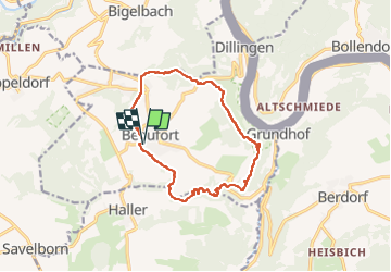
Ruta Senderismo de 12,8 km a descubrir en Desconocido, Canton Echternach, Beaufort. Esta ruta ha sido propuesta por micheldutilleul.
Descripción
Belle balade, au départ du château de Beaufort. Possibilité de visiter les ruines du château.
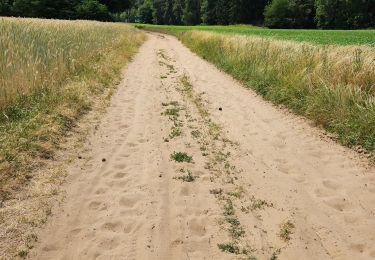
Une partie le long de la rivière.
Localización
País:
Luxembourg
Región :
Desconocido
Departamento/provincia :
Canton Echternach
Municipio :
Beaufort
Localidad:
Unknown
Salida:(Dec)
Salida:(UTM)
304955 ; 5523613 (32U) N.
Comentarios
Excursiones cerca
![Excursión Senderismo Waldbillig - 2024-08-10_15h10m00_Sentier_local_-_W4 - Photo](https://media.geolcdn.com/t/375/260/d315698e-faa8-4cbd-932a-8a7221249730.jpg&format=jpg&maxdim=2)
![Senderismo Senderismo](https://static1.geolcdn.com/sitytour/trail-icons/101.png)
2024-08-10_15h10m00_Sentier_local_-_W4
Senderismo
Medio
(1)
Waldbillig,
Desconocido,
Canton Echternach,
Luxembourg
![](/images/other/stat-length.png)
6,2 km | 7,8 km-effort
1h 45min
![](https://static1.geolcdn.com/siteimages/upload/files/16400158638029165_repeat_loop_refresh_sync_direction_icon.png)
Sí
![Excursión Senderismo Berdorf - Berdorf - B2 - Müllerthal - Photo](https://media.geolcdn.com/t/375/260/517daf86-eb8b-412e-9a7e-d0a346807e81.jpg&format=jpg&maxdim=2)
![Senderismo Senderismo](https://static1.geolcdn.com/sitytour/trail-icons/101.png)
Berdorf - B2 - Müllerthal
Senderismo
Medio
(2)
Berdorf,
Desconocido,
Canton Echternach,
Luxembourg
![](/images/other/stat-length.png)
6,7 km | 8,5 km-effort
1h 35min
![](https://static1.geolcdn.com/siteimages/upload/files/16400158638029165_repeat_loop_refresh_sync_direction_icon.png)
Sí
![Excursión Senderismo Beaufort - 2021-07-05_20h10m00_gpx-file (1) - Photo](https://media.geolcdn.com/t/375/260/9b40ebf8-55f0-408d-8504-76ef1490c879.jpg&format=jpg&maxdim=2)
![Senderismo Senderismo](https://static1.geolcdn.com/sitytour/trail-icons/101.png)
2021-07-05_20h10m00_gpx-file (1)
Senderismo
Medio
(1)
Beaufort,
Desconocido,
Canton Echternach,
Luxembourg
![](/images/other/stat-length.png)
10,6 km | 13,6 km-effort
3h 5min
![](https://static1.geolcdn.com/siteimages/upload/files/16400158638029165_repeat_loop_refresh_sync_direction_icon.png)
Sí
![Excursión Senderismo Beaufort - 2021-07-05_19h47m20_gpx-file - Photo](https://media.geolcdn.com/t/375/260/a4bdebcf-ad8b-4513-aa3a-a5e6b3892888.jpg&format=jpg&maxdim=2)
![Senderismo Senderismo](https://static1.geolcdn.com/sitytour/trail-icons/101.png)
2021-07-05_19h47m20_gpx-file
Senderismo
Medio
(2)
Beaufort,
Desconocido,
Canton Echternach,
Luxembourg
![](/images/other/stat-length.png)
12,9 km | 16,8 km-effort
3h 48min
![](https://static1.geolcdn.com/siteimages/upload/files/16400158638029165_repeat_loop_refresh_sync_direction_icon.png)
Sí
![Excursión Senderismo Waldbillig - Mullerthal randonnée magnifique - Photo](https://media.geolcdn.com/t/375/260/3f58fb00-23e0-4e5f-be44-94a05c44c601.jpg&format=jpg&maxdim=2)
![Senderismo Senderismo](https://static1.geolcdn.com/sitytour/trail-icons/101.png)
Mullerthal randonnée magnifique
Senderismo
Difícil
(4)
Waldbillig,
Desconocido,
Canton Echternach,
Luxembourg
![](/images/other/stat-length.png)
9,3 km | 12,9 km-effort
4h 21min
![](https://static1.geolcdn.com/siteimages/upload/files/16400158638029165_repeat_loop_refresh_sync_direction_icon.png)
Sí
![Excursión Senderismo Reisdorf - R2 - Photo](https://media.geolcdn.com/t/375/260/7552b052-379e-4866-b586-5f7ed6a8b465.jpeg&format=jpg&maxdim=2)
![Senderismo Senderismo](https://static1.geolcdn.com/sitytour/trail-icons/101.png)
R2
Senderismo
Fácil
(1)
Reisdorf,
Desconocido,
Canton Diekirch,
Luxembourg
![](/images/other/stat-length.png)
2,9 km | 4,2 km-effort
56min
![](https://static1.geolcdn.com/siteimages/upload/files/16400158638029165_repeat_loop_refresh_sync_direction_icon.png)
Sí
![Excursión Senderismo Berdorf - 2023-06-03_18h17m36_Sentier_local_-_B8 - Photo](https://media.geolcdn.com/t/375/260/7a8870ac-d558-4a39-b7c2-bdeb26e936c0.jpg&format=jpg&maxdim=2)
![Senderismo Senderismo](https://static1.geolcdn.com/sitytour/trail-icons/101.png)
2023-06-03_18h17m36_Sentier_local_-_B8
Senderismo
Medio
(2)
Berdorf,
Desconocido,
Canton Echternach,
Luxembourg
![](/images/other/stat-length.png)
11,7 km | 15 km-effort
3h 24min
![](https://static1.geolcdn.com/siteimages/upload/files/16400158638029165_repeat_loop_refresh_sync_direction_icon.png)
Sí
![Excursión Senderismo Waldbillig - MÜLLERTHAL (Cascades) - Photo](https://media.geolcdn.com/t/375/260/ext.jpg?maxdim=2&url=https%3A%2F%2Fservices.sitytrail.com%2FGeolivesWS%2FDownloadMedia.ashx%3FTrailID%3D815203%26Media%3Dfix__20170822135510.jpg)
![Senderismo Senderismo](https://static1.geolcdn.com/sitytour/trail-icons/101.png)
MÜLLERTHAL (Cascades)
Senderismo
Medio
(1)
Waldbillig,
Desconocido,
Canton Echternach,
Luxembourg
![](/images/other/stat-length.png)
10,2 km | 13,7 km-effort
3h 1min
![](https://static1.geolcdn.com/siteimages/upload/files/16400158638029165_repeat_loop_refresh_sync_direction_icon.png)
Sí
![Excursión Otra actividad Waldbillig - Luxemburg: Mullerthal - Consdorf - Mullerthal - Photo](https://media.geolcdn.com/t/375/260/ext.jpg?maxdim=2&url=https%3A%2F%2Fservices.sitytrail.com%2FGeolivesWS%2FDownloadMedia.ashx%3FTrailID%3D727411%26Media%3D20170405143630.jpg)
![Otra actividad Otra actividad](https://static1.geolcdn.com/sitytour/trail-icons/900.png)
Luxemburg: Mullerthal - Consdorf - Mullerthal
Otra actividad
Muy difícil
(3)
Waldbillig,
Desconocido,
Canton Echternach,
Luxembourg
![](/images/other/stat-length.png)
11,5 km | 15,4 km-effort
4h 10min
![](https://static1.geolcdn.com/siteimages/upload/files/16400158638029165_repeat_loop_refresh_sync_direction_icon.png)
Sí