![](/images/other/stat-length.png)
![Excursión Senderismo Assesse - COURRIERE (Bois de Sorinne) - Photo](https://media.geolcdn.com/t/1900/400/ext.pjpeg?maxdim=2&url=https%3A%2F%2Fstatic1.geolcdn.com%2Fsiteimages%2Fupload%2Ffiles%2F1553511878bg_sport_marche.png)
COURRIERE (Bois de Sorinne)
GerardBouche
Usuario
![Longitud](/images/other/stat-length.png)
Longitud
9,3 km
![Altitud máxima](https://static1.geolcdn.com/siteimages/upload/files/1508320355ic_sort_altitude_max_24dp.png)
Altitud máxima
284 m
![Desnivel positivo](https://static1.geolcdn.com/siteimages/upload/files/1508320355ic_sort_den_pos_24dp.png)
Desnivel positivo
168 m
![Km-Effort](/images/other/stat-length.png)
Km-Effort
11,6 km
![Altitud mínima](https://static1.geolcdn.com/siteimages/upload/files/1508320355ic_sort_altitude_min_24dp.png)
Altitud mínima
189 m
![Desnivel negativo](https://static1.geolcdn.com/siteimages/upload/files/1508320355ic_sort_den_neg_24dp.png)
Desnivel negativo
168 m
![Boucle](https://static1.geolcdn.com/siteimages/upload/files/16400158638029165_repeat_loop_refresh_sync_direction_icon.png)
Boucle
Sí
Fecha de creación :
2015-08-09 00:00:00.0
Última modificación :
2015-08-09 00:00:00.0
![Senderismo](https://static1.geolcdn.com/sitytour/trail-icons/101.png)
2h39
Dificultad : Fácil
![Escanee este código QR para abrir la excursión en la aplicación SityTrail](https://capi.geolives.com/qq0zvz2zws4bq2lad0pu/sitytour/trails/342482/qr.png?size=200)
Aplicación GPS de excursión GRATIS
A propósito
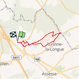
Ruta Senderismo de 9,3 km a descubrir en Valonia, Namur, Assesse. Esta ruta ha sido propuesta por GerardBouche.
Descripción
Eglise-->Bois de Sorine-la-Longue par "Li Yerdau"-->la source du "Scratch"-->le Samson et les "Vergers Conservatoires" de Bethleem.
Localización
País:
Belgium
Región :
Valonia
Departamento/provincia :
Namur
Municipio :
Assesse
Localidad:
Courrière
Salida:(Dec)
Salida:(UTM)
641312 ; 5584256 (31U) N.
Comentarios
Excursiones cerca
![Excursión Senderismo Assesse - RB-Na-02 Raccourci - Les collines de la vallée du Bocq - Photo](https://media.geolcdn.com/t/375/260/ext.jpg?maxdim=2&url=https%3A%2F%2Fservices.sitytrail.com%2FGeolivesWS%2FDownloadMedia.ashx%3FTrailID%3D794014%26Media%3Dc4c97e29-7bfb-495c-ae56-13528ce8d0b3.JPG)
![Senderismo Senderismo](https://static1.geolcdn.com/sitytour/trail-icons/101.png)
RB-Na-02 Raccourci - Les collines de la vallée du Bocq
Senderismo
Medio
(7)
Assesse,
Valonia,
Namur,
Belgium
![](/images/other/stat-length.png)
17 km | 23 km-effort
5h 32min
![](https://static1.geolcdn.com/siteimages/upload/files/16400158638029165_repeat_loop_refresh_sync_direction_icon.png)
Sí
![Excursión Senderismo Assesse - RB-Na-02 Les collines de la vallée du Bocq - Photo](https://media.geolcdn.com/t/375/260/ext.jpg?maxdim=2&url=https%3A%2F%2Fservices.sitytrail.com%2FGeolivesWS%2FDownloadMedia.ashx%3FTrailID%3D250531%26Media%3Dc4c97e29-7bfb-495c-ae56-13528ce8d0b3.JPG)
![Senderismo Senderismo](https://static1.geolcdn.com/sitytour/trail-icons/101.png)
RB-Na-02 Les collines de la vallée du Bocq
Senderismo
Medio
(21)
Assesse,
Valonia,
Namur,
Belgium
![](/images/other/stat-length.png)
21 km | 28 km-effort
5h 32min
![](https://static1.geolcdn.com/siteimages/upload/files/16400158638029165_repeat_loop_refresh_sync_direction_icon.png)
Sí
![Excursión Senderismo Gesves - RB-Na-01 Raccourci - Vallée du Samson en Condroz namurois - Photo](https://media.geolcdn.com/t/375/260/ext.jpg?maxdim=2&url=https%3A%2F%2Fservices.sitytrail.com%2FGeolivesWS%2FDownloadMedia.ashx%3FTrailID%3D213609%26Media%3D506f23b2-0581-4f03-b006-9ca575596278.jpg)
![Senderismo Senderismo](https://static1.geolcdn.com/sitytour/trail-icons/101.png)
RB-Na-01 Raccourci - Vallée du Samson en Condroz namurois
Senderismo
Muy difícil
(15)
Gesves,
Valonia,
Namur,
Belgium
![](/images/other/stat-length.png)
18,3 km | 25 km-effort
5h 34min
![](https://static1.geolcdn.com/siteimages/upload/files/16400158638029165_repeat_loop_refresh_sync_direction_icon.png)
Sí
![Excursión Senderismo Gesves - RB-Na-01 Vallée du Samson en Condroz namurois - Photo](https://media.geolcdn.com/t/375/260/ext.jpg?maxdim=2&url=https%3A%2F%2Fservices.sitytrail.com%2FGeolivesWS%2FDownloadMedia.ashx%3FTrailID%3D179626%26Media%3D506f23b2-0581-4f03-b006-9ca575596278.jpg)
![Senderismo Senderismo](https://static1.geolcdn.com/sitytour/trail-icons/101.png)
RB-Na-01 Vallée du Samson en Condroz namurois
Senderismo
Muy difícil
(15)
Gesves,
Valonia,
Namur,
Belgium
![](/images/other/stat-length.png)
25 km | 33 km-effort
7h 26min
![](https://static1.geolcdn.com/siteimages/upload/files/16400158638029165_repeat_loop_refresh_sync_direction_icon.png)
Sí
![Excursión Senderismo Gesves - GESVES- Le Pré D'Amite- N°07- Bois - Photo](https://media.geolcdn.com/t/375/260/ext.jpg?maxdim=2&url=https%3A%2F%2Fservices.sitytrail.com%2FGeolivesWS%2FDownloadMedia.ashx%3FTrailID%3D121401%26Media%3D56c27e3a-fec1-4804-be43-ac45373f04b7.jpg)
![Senderismo Senderismo](https://static1.geolcdn.com/sitytour/trail-icons/101.png)
GESVES- Le Pré D'Amite- N°07- Bois
Senderismo
Difícil
(13)
Gesves,
Valonia,
Namur,
Belgium
![](/images/other/stat-length.png)
9,4 km | 12,5 km-effort
2h 41min
![](https://static1.geolcdn.com/siteimages/upload/files/16400158638029165_repeat_loop_refresh_sync_direction_icon.png)
Sí
![Excursión Senderismo Assesse - 05 Paysage condruzien - Photo](https://media.geolcdn.com/t/375/260/ext.jpg?maxdim=2&url=https%3A%2F%2Fservices.sitytrail.com%2FGeolivesWS%2FDownloadMedia.ashx%3FTrailID%3D121392%26Media%3D31d83d0c-5bcd-44cd-b8d6-1cc6a3d25bf9.jpg)
![Senderismo Senderismo](https://static1.geolcdn.com/sitytour/trail-icons/101.png)
05 Paysage condruzien
Senderismo
Fácil
(5)
Assesse,
Valonia,
Namur,
Belgium
![](/images/other/stat-length.png)
10,2 km | 13,3 km-effort
2h 11min
![](https://static1.geolcdn.com/siteimages/upload/files/16400158638029165_repeat_loop_refresh_sync_direction_icon.png)
No
![Excursión Senderismo Namur - De Naninne vers Dave par les Fonds de Lustin et les Bois d'Acremont - Photo](https://media.geolcdn.com/t/375/260/ext.jpg?maxdim=2&url=https%3A%2F%2Fstatic1.geolcdn.com%2Fsiteimages%2Fupload%2Ffiles%2F1553511878bg_sport_marche.png)
![Senderismo Senderismo](https://static1.geolcdn.com/sitytour/trail-icons/101.png)
De Naninne vers Dave par les Fonds de Lustin et les Bois d'Acremont
Senderismo
Medio
(5)
Namur,
Valonia,
Namur,
Belgium
![](/images/other/stat-length.png)
19 km | 25 km-effort
5h 0min
![](https://static1.geolcdn.com/siteimages/upload/files/16400158638029165_repeat_loop_refresh_sync_direction_icon.png)
Sí
![Excursión Senderismo Assesse - GG-Na-18_Sart-Bernard - Andenne - Photo](https://media.geolcdn.com/t/375/260/ee170bcd-2fb4-4927-aeb6-2a32aed3e834.jpg&format=jpg&maxdim=2)
![Senderismo Senderismo](https://static1.geolcdn.com/sitytour/trail-icons/101.png)
GG-Na-18_Sart-Bernard - Andenne
Senderismo
Muy difícil
(1)
Assesse,
Valonia,
Namur,
Belgium
![](/images/other/stat-length.png)
25 km | 32 km-effort
6h 49min
![](https://static1.geolcdn.com/siteimages/upload/files/16400158638029165_repeat_loop_refresh_sync_direction_icon.png)
No
![Excursión Senderismo Assesse - Promenade à Crupet - Photo](https://media.geolcdn.com/t/375/260/ext.jpg?maxdim=2&url=https%3A%2F%2Fservices.sitytrail.com%2FGeolivesWS%2FDownloadMedia.ashx%3FTrailID%3D532928%26Media%3De78ba70e-0d4d-4d8c-b509-37ad32b8d33e.jpg)
![Senderismo Senderismo](https://static1.geolcdn.com/sitytour/trail-icons/101.png)
Promenade à Crupet
Senderismo
Fácil
(3)
Assesse,
Valonia,
Namur,
Belgium
![](/images/other/stat-length.png)
8,3 km | 11,4 km-effort
2h 30min
![](https://static1.geolcdn.com/siteimages/upload/files/16400158638029165_repeat_loop_refresh_sync_direction_icon.png)
Sí