![](/images/other/stat-length.png)
![Excursión Senderismo Lièpvre - tour du val d'argent - Photo](https://media.geolcdn.com/t/1900/400/ext.pjpeg?maxdim=2&url=https%3A%2F%2Fstatic1.geolcdn.com%2Fsiteimages%2Fupload%2Ffiles%2F1553511878bg_sport_marche.png)
tour du val d'argent
grattounette
Usuario
![Longitud](/images/other/stat-length.png)
Longitud
63 km
![Altitud máxima](https://static1.geolcdn.com/siteimages/upload/files/1508320355ic_sort_altitude_max_24dp.png)
Altitud máxima
1216 m
![Desnivel positivo](https://static1.geolcdn.com/siteimages/upload/files/1508320355ic_sort_den_pos_24dp.png)
Desnivel positivo
2759 m
![Km-Effort](/images/other/stat-length.png)
Km-Effort
100 km
![Altitud mínima](https://static1.geolcdn.com/siteimages/upload/files/1508320355ic_sort_altitude_min_24dp.png)
Altitud mínima
268 m
![Desnivel negativo](https://static1.geolcdn.com/siteimages/upload/files/1508320355ic_sort_den_neg_24dp.png)
Desnivel negativo
2761 m
![Boucle](https://static1.geolcdn.com/siteimages/upload/files/16400158638029165_repeat_loop_refresh_sync_direction_icon.png)
Boucle
Sí
Fecha de creación :
2014-12-10 00:00:00.0
Última modificación :
2014-12-10 00:00:00.0
![Senderismo](https://static1.geolcdn.com/sitytour/trail-icons/101.png)
18h02
Dificultad : Muy difícil
![Escanee este código QR para abrir la excursión en la aplicación SityTrail](https://capi.geolives.com/qq0zvz2zws4bq2lad0pu/sitytour/trails/341005/qr.png?size=200)
Aplicación GPS de excursión GRATIS
A propósito
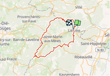
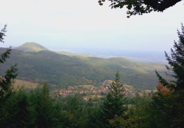
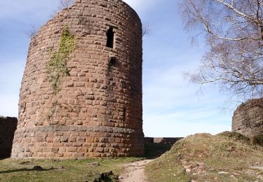
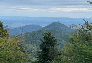
Ruta Senderismo de 63 km a descubrir en Gran Este, Alto Rin, Lièpvre. Esta ruta ha sido propuesta por grattounette.
Descripción
départ de liepvre nuit en gîte au col des bagenelles et retour sur liepvre randonnée sur 2 jours pour marcheurs avertis
Localización
País:
France
Región :
Gran Este
Departamento/provincia :
Alto Rin
Municipio :
Lièpvre
Localidad:
Unknown
Salida:(Dec)
Salida:(UTM)
372288 ; 5348264 (32U) N.
Comentarios
Excursiones cerca
![Excursión Senderismo La Vancelle - 2020-05-21 Marche La Vancelle Boucle - Photo](https://media.geolcdn.com/t/375/260/45f73326-854e-41a0-95ea-dc1c83334d8a.jpg&format=jpg&maxdim=2)
![Senderismo Senderismo](https://static1.geolcdn.com/sitytour/trail-icons/101.png)
2020-05-21 Marche La Vancelle Boucle
Senderismo
Muy fácil
La Vancelle,
Gran Este,
Bajo-Rin,
France
![](/images/other/stat-length.png)
16,3 km | 26 km-effort
6h 41min
![](https://static1.geolcdn.com/siteimages/upload/files/16400158638029165_repeat_loop_refresh_sync_direction_icon.png)
Sí
![Excursión Senderismo La Vancelle - 2015-01-02 Marche Rocher du Coucou Chateau Frankenbourg - Photo](https://media.geolcdn.com/t/375/260/ext.jpg?maxdim=2&url=https%3A%2F%2Fstatic1.geolcdn.com%2Fsiteimages%2Fupload%2Ffiles%2F1553511878bg_sport_marche.png)
![Senderismo Senderismo](https://static1.geolcdn.com/sitytour/trail-icons/101.png)
2015-01-02 Marche Rocher du Coucou Chateau Frankenbourg
Senderismo
Fácil
(1)
La Vancelle,
Gran Este,
Bajo-Rin,
France
![](/images/other/stat-length.png)
10,9 km | 18,1 km-effort
3h 47min
![](https://static1.geolcdn.com/siteimages/upload/files/16400158638029165_repeat_loop_refresh_sync_direction_icon.png)
Sí
![Excursión Senderismo Breitenau - 2024-07-23_20h26m34_G 12 - Photo](https://media.geolcdn.com/t/375/260/ext.jpg?maxdim=2&url=https%3A%2F%2Fstatic1.geolcdn.com%2Fsiteimages%2Fupload%2Ffiles%2F1553511878bg_sport_marche.png)
![Senderismo Senderismo](https://static1.geolcdn.com/sitytour/trail-icons/101.png)
2024-07-23_20h26m34_G 12
Senderismo
Fácil
(1)
Breitenau,
Gran Este,
Bajo-Rin,
France
![](/images/other/stat-length.png)
15,4 km | 22 km-effort
4h 59min
![](https://static1.geolcdn.com/siteimages/upload/files/16400158638029165_repeat_loop_refresh_sync_direction_icon.png)
Sí
![Excursión Bici de montaña Bergheim - 1 ère sortie - Photo](https://media.geolcdn.com/t/375/260/57e3216c-710e-4acb-980c-a1a007f80923.jpg&format=jpg&maxdim=2)
![Bici de montaña Bici de montaña](https://static1.geolcdn.com/sitytour/trail-icons/202.png)
1 ère sortie
Bici de montaña
Fácil
Bergheim,
Gran Este,
Alto Rin,
France
![](/images/other/stat-length.png)
12,6 km | 19,1 km-effort
1h 53min
![](https://static1.geolcdn.com/siteimages/upload/files/16400158638029165_repeat_loop_refresh_sync_direction_icon.png)
Sí
![Senderismo Senderismo](https://static1.geolcdn.com/sitytour/trail-icons/101.png)
20230309_BREITENAU_rando_Breitenau_Le Rocher du Coucou - Le Château du Franke...
Senderismo
Medio
Breitenau,
Gran Este,
Bajo-Rin,
France
![](/images/other/stat-length.png)
14,5 km | 24 km-effort
5h 24min
![](https://static1.geolcdn.com/siteimages/upload/files/16400158638029165_repeat_loop_refresh_sync_direction_icon.png)
Sí
![Excursión Senderismo Rombach-le-Franc - Col de Fouchy - Photo](https://media.geolcdn.com/t/375/260/d71f8170-2b95-4d63-8fe6-ab7a52c9f1d0.jpg&format=jpg&maxdim=2)
![Senderismo Senderismo](https://static1.geolcdn.com/sitytour/trail-icons/101.png)
Col de Fouchy
Senderismo
Medio
Rombach-le-Franc,
Gran Este,
Alto Rin,
France
![](/images/other/stat-length.png)
11,8 km | 17,6 km-effort
3h 23min
![](https://static1.geolcdn.com/siteimages/upload/files/16400158638029165_repeat_loop_refresh_sync_direction_icon.png)
Sí
![Excursión Senderismo Lièpvre - Liépvre - Roche des Fées, Roche de Chalmont, Rocher du Coucou, château du Frankenbourg - Photo](https://media.geolcdn.com/t/375/260/bc9e5781-8dbd-488c-b7a5-232842474208.jpg&format=jpg&maxdim=2)
![Senderismo Senderismo](https://static1.geolcdn.com/sitytour/trail-icons/101.png)
Liépvre - Roche des Fées, Roche de Chalmont, Rocher du Coucou, château du Fra...
Senderismo
Difícil
Lièpvre,
Gran Este,
Alto Rin,
France
![](/images/other/stat-length.png)
19,4 km | 31 km-effort
5h 53min
![](https://static1.geolcdn.com/siteimages/upload/files/16400158638029165_repeat_loop_refresh_sync_direction_icon.png)
Sí
![Excursión Senderismo Thannenkirch - Thannenkirch / rocher pointu / rocher des géants - Photo](https://media.geolcdn.com/t/375/260/9a1534c9-c17d-4f24-8042-3ca6104f41c2.jpg&format=jpg&maxdim=2)
![Senderismo Senderismo](https://static1.geolcdn.com/sitytour/trail-icons/101.png)
Thannenkirch / rocher pointu / rocher des géants
Senderismo
Difícil
(1)
Thannenkirch,
Gran Este,
Alto Rin,
France
![](/images/other/stat-length.png)
7,1 km | 13,4 km-effort
2h 8min
![](https://static1.geolcdn.com/siteimages/upload/files/16400158638029165_repeat_loop_refresh_sync_direction_icon.png)
Sí
![Excursión Senderismo Thannenkirch - TAENCHEL CCA 200827 - Photo](https://media.geolcdn.com/t/375/260/1365aae2-4887-4691-885c-9c80121582d8.jpg&format=jpg&maxdim=2)
![Senderismo Senderismo](https://static1.geolcdn.com/sitytour/trail-icons/101.png)
TAENCHEL CCA 200827
Senderismo
Muy fácil
Thannenkirch,
Gran Este,
Alto Rin,
France
![](/images/other/stat-length.png)
12,7 km | 18,7 km-effort
5h 2min
![](https://static1.geolcdn.com/siteimages/upload/files/16400158638029165_repeat_loop_refresh_sync_direction_icon.png)
Sí