![](/images/other/stat-length.png)
![Excursión Senderismo Saint-Léger-du-Ventoux - saint leger mont serein - Photo](https://media.geolcdn.com/t/1900/400/ext.pjpeg?maxdim=2&url=https%3A%2F%2Fstatic1.geolcdn.com%2Fsiteimages%2Fupload%2Ffiles%2F1553511878bg_sport_marche.png)
saint leger mont serein
mesrandos
Usuario
![Longitud](/images/other/stat-length.png)
Longitud
18,4 km
![Altitud máxima](https://static1.geolcdn.com/siteimages/upload/files/1508320355ic_sort_altitude_max_24dp.png)
Altitud máxima
1350 m
![Desnivel positivo](https://static1.geolcdn.com/siteimages/upload/files/1508320355ic_sort_den_pos_24dp.png)
Desnivel positivo
963 m
![Km-Effort](/images/other/stat-length.png)
Km-Effort
31 km
![Altitud mínima](https://static1.geolcdn.com/siteimages/upload/files/1508320355ic_sort_altitude_min_24dp.png)
Altitud mínima
398 m
![Desnivel negativo](https://static1.geolcdn.com/siteimages/upload/files/1508320355ic_sort_den_neg_24dp.png)
Desnivel negativo
977 m
![Boucle](https://static1.geolcdn.com/siteimages/upload/files/16400158638029165_repeat_loop_refresh_sync_direction_icon.png)
Boucle
Sí
Fecha de creación :
2014-12-10 00:00:00.0
Última modificación :
2014-12-10 00:00:00.0
![Senderismo](https://static1.geolcdn.com/sitytour/trail-icons/101.png)
5h09
Dificultad : Medio
![Escanee este código QR para abrir la excursión en la aplicación SityTrail](https://capi.geolives.com/qq0zvz2zws4bq2lad0pu/sitytour/trails/340938/qr.png?size=200)
Aplicación GPS de excursión GRATIS
A propósito
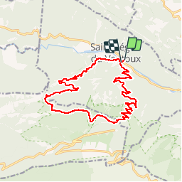
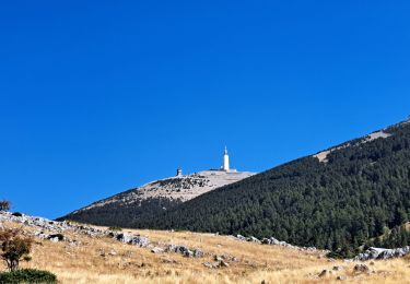
Ruta Senderismo de 18,4 km a descubrir en Provenza-Alpes-Costa Azul, Vaucluse, Saint-Léger-du-Ventoux. Esta ruta ha sido propuesta por mesrandos.
Descripción
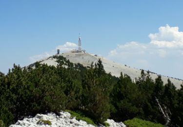
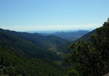
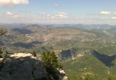
la montée sympatique, descente au début moins intéressante car beaucoup de cailloux et de la piste mais la vue sympa la fin sur sentier bien
Localización
País:
France
Región :
Provenza-Alpes-Costa Azul
Departamento/provincia :
Vaucluse
Municipio :
Saint-Léger-du-Ventoux
Localidad:
Unknown
Salida:(Dec)
Salida:(UTM)
682157 ; 4897665 (31T) N.
Comentarios
Excursiones cerca
![Excursión Senderismo Beaumont-du-Ventoux - Le Ventoux - Corniche Nord - Photo](https://media.geolcdn.com/t/375/260/ext.jpg?maxdim=2&url=https%3A%2F%2Fservices.sitytrail.com%2FGeolivesWS%2FDownloadMedia.ashx%3FTrailID%3D105329%26Media%3D9023_2.jpg)
![Senderismo Senderismo](https://static1.geolcdn.com/sitytour/trail-icons/101.png)
Le Ventoux - Corniche Nord
Senderismo
Difícil
(2)
Beaumont-du-Ventoux,
Provenza-Alpes-Costa Azul,
Vaucluse,
France
![](/images/other/stat-length.png)
19,1 km | 30 km-effort
6h 30min
![](https://static1.geolcdn.com/siteimages/upload/files/16400158638029165_repeat_loop_refresh_sync_direction_icon.png)
Sí
![Excursión Senderismo Beaumont-du-Ventoux - Sentier de découverte au Mont Serein - Photo](https://media.geolcdn.com/t/375/260/ext.jpg?maxdim=2&url=https%3A%2F%2Fservices.sitytrail.com%2FGeolivesWS%2FDownloadMedia.ashx%3FTrailID%3D103767%26Media%3D6520_2.jpg)
![Senderismo Senderismo](https://static1.geolcdn.com/sitytour/trail-icons/101.png)
Sentier de découverte au Mont Serein
Senderismo
Medio
(2)
Beaumont-du-Ventoux,
Provenza-Alpes-Costa Azul,
Vaucluse,
France
![](/images/other/stat-length.png)
6,3 km | 8,2 km-effort
2h 0min
![](https://static1.geolcdn.com/siteimages/upload/files/16400158638029165_repeat_loop_refresh_sync_direction_icon.png)
Sí
![Excursión Senderismo Beaumont-du-Ventoux - Crêtes du Ventoux - Photo](https://media.geolcdn.com/t/375/260/91441923-a9c0-4765-9dda-d1eb9e281d5f.jpg&format=jpg&maxdim=2)
![Senderismo Senderismo](https://static1.geolcdn.com/sitytour/trail-icons/101.png)
Crêtes du Ventoux
Senderismo
Difícil
Beaumont-du-Ventoux,
Provenza-Alpes-Costa Azul,
Vaucluse,
France
![](/images/other/stat-length.png)
18,8 km | 29 km-effort
6h 4min
![](https://static1.geolcdn.com/siteimages/upload/files/16400158638029165_repeat_loop_refresh_sync_direction_icon.png)
Sí
![Excursión Senderismo Brantes - Ascencion du Ventoux sur 2 jours j1 - Photo](https://media.geolcdn.com/t/375/260/f9d58ab5-05c4-42e7-b010-c69a5ea3f997.jpg&format=jpg&maxdim=2)
![Senderismo Senderismo](https://static1.geolcdn.com/sitytour/trail-icons/101.png)
Ascencion du Ventoux sur 2 jours j1
Senderismo
Muy difícil
Brantes,
Provenza-Alpes-Costa Azul,
Vaucluse,
France
![](/images/other/stat-length.png)
22 km | 40 km-effort
8h 53min
![](https://static1.geolcdn.com/siteimages/upload/files/16400158638029165_repeat_loop_refresh_sync_direction_icon.png)
No
![Excursión Senderismo Beaumont-du-Ventoux - Ascension du Ventoux versant nord - Photo](https://media.geolcdn.com/t/375/260/22f53a61-90b8-424b-b027-8242692a4006.jpg&format=jpg&maxdim=2)
![Senderismo Senderismo](https://static1.geolcdn.com/sitytour/trail-icons/101.png)
Ascension du Ventoux versant nord
Senderismo
Muy difícil
Beaumont-du-Ventoux,
Provenza-Alpes-Costa Azul,
Vaucluse,
France
![](/images/other/stat-length.png)
24 km | 0 m-effort
7h 31min
![](https://static1.geolcdn.com/siteimages/upload/files/16400158638029165_repeat_loop_refresh_sync_direction_icon.png)
Sí
![Excursión Senderismo Bédoin - Mont Ventoux GR 4-9 - Photo](https://media.geolcdn.com/t/375/260/ext.jpg?maxdim=2&url=https%3A%2F%2Fservices.sitytrail.com%2FGeolivesWS%2FDownloadMedia.ashx%3FTrailID%3D328708%26Media%3Dfix__20140727163108.jpg)
![Senderismo Senderismo](https://static1.geolcdn.com/sitytour/trail-icons/101.png)
Mont Ventoux GR 4-9
Senderismo
Medio
(1)
Bédoin,
Provenza-Alpes-Costa Azul,
Vaucluse,
France
![](/images/other/stat-length.png)
19,2 km | 30 km-effort
5h 43min
![](https://static1.geolcdn.com/siteimages/upload/files/16400158638029165_repeat_loop_refresh_sync_direction_icon.png)
Sí
![Excursión Senderismo Beaumont-du-Ventoux - Ventoux et crêtes - Photo](https://media.geolcdn.com/t/375/260/ext.jpg?maxdim=2&url=https%3A%2F%2Fstatic1.geolcdn.com%2Fsiteimages%2Fupload%2Ffiles%2F1553511878bg_sport_marche.png)
![Senderismo Senderismo](https://static1.geolcdn.com/sitytour/trail-icons/101.png)
Ventoux et crêtes
Senderismo
Medio
(1)
Beaumont-du-Ventoux,
Provenza-Alpes-Costa Azul,
Vaucluse,
France
![](/images/other/stat-length.png)
13,7 km | 22 km-effort
3h 25min
![](https://static1.geolcdn.com/siteimages/upload/files/16400158638029165_repeat_loop_refresh_sync_direction_icon.png)
Sí
![Excursión Senderismo Beaumont-du-Ventoux - Mont Ventoux - Photo](https://media.geolcdn.com/t/375/260/3ae4520c-78a2-454a-8004-d91d75c92fa0.jpg&format=jpg&maxdim=2)
![Senderismo Senderismo](https://static1.geolcdn.com/sitytour/trail-icons/101.png)
Mont Ventoux
Senderismo
Muy difícil
Beaumont-du-Ventoux,
Provenza-Alpes-Costa Azul,
Vaucluse,
France
![](/images/other/stat-length.png)
17,6 km | 27 km-effort
6h 26min
![](https://static1.geolcdn.com/siteimages/upload/files/16400158638029165_repeat_loop_refresh_sync_direction_icon.png)
Sí
![Excursión Senderismo Beaumont-du-Ventoux - Mont ventoux par les grands près - Photo](https://media.geolcdn.com/t/375/260/e304fce5-a82a-4d93-9974-04f259be224c.jpg&format=jpg&maxdim=2)
![Senderismo Senderismo](https://static1.geolcdn.com/sitytour/trail-icons/101.png)
Mont ventoux par les grands près
Senderismo
Difícil
Beaumont-du-Ventoux,
Provenza-Alpes-Costa Azul,
Vaucluse,
France
![](/images/other/stat-length.png)
17,2 km | 27 km-effort
6h 1min
![](https://static1.geolcdn.com/siteimages/upload/files/16400158638029165_repeat_loop_refresh_sync_direction_icon.png)
Sí