![](/images/other/stat-length.png)
![Excursión Senderismo Belvédère - Tour du Grand Capelet - Photo](https://media.geolcdn.com/t/1900/400/ext.pjpeg?maxdim=2&url=https%3A%2F%2Fservices.sitytrail.com%2FGeolivesWS%2FDownloadMedia.ashx%3FTrailID%3D340416%26Media%3D7d80123a-286e-4e17-97c2-870a2d34fbf7.jpg)
Tour du Grand Capelet
lecynophile
Usuario
![Longitud](/images/other/stat-length.png)
Longitud
18,8 km
![Altitud máxima](https://static1.geolcdn.com/siteimages/upload/files/1508320355ic_sort_altitude_max_24dp.png)
Altitud máxima
2698 m
![Desnivel positivo](https://static1.geolcdn.com/siteimages/upload/files/1508320355ic_sort_den_pos_24dp.png)
Desnivel positivo
1499 m
![Km-Effort](/images/other/stat-length.png)
Km-Effort
39 km
![Altitud mínima](https://static1.geolcdn.com/siteimages/upload/files/1508320355ic_sort_altitude_min_24dp.png)
Altitud mínima
1685 m
![Desnivel negativo](https://static1.geolcdn.com/siteimages/upload/files/1508320355ic_sort_den_neg_24dp.png)
Desnivel negativo
1497 m
![Boucle](https://static1.geolcdn.com/siteimages/upload/files/16400158638029165_repeat_loop_refresh_sync_direction_icon.png)
Boucle
Sí
Fecha de creación :
2014-12-10 00:00:00.0
Última modificación :
2014-12-10 00:00:00.0
![Senderismo](https://static1.geolcdn.com/sitytour/trail-icons/101.png)
9h00
Dificultad : Difícil
![Escanee este código QR para abrir la excursión en la aplicación SityTrail](https://capi.geolives.com/qq0zvz2zws4bq2lad0pu/sitytour/trails/340416/qr.png?size=200)
Aplicación GPS de excursión GRATIS
A propósito
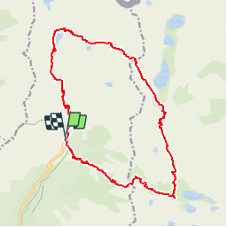
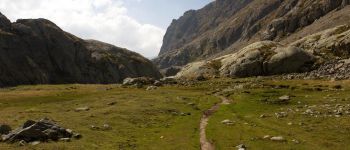
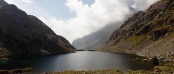
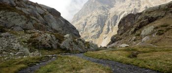
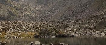
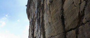
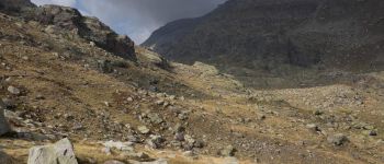
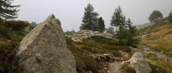
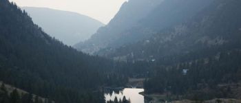
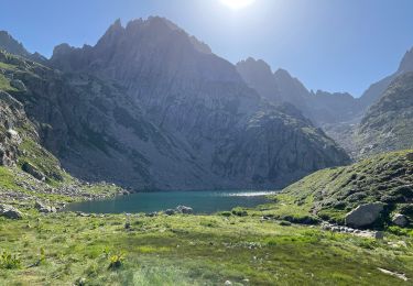
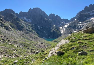
Ruta Senderismo de 18,8 km a descubrir en Provenza-Alpes-Costa Azul, Alpes Marítimos, Belvédère. Esta ruta ha sido propuesta por lecynophile.
Descripción
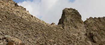
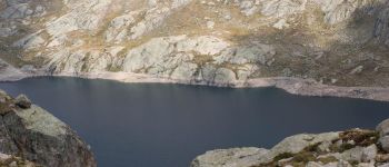
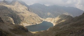
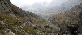
Tour du Grand Capelet :
- Pont du Countet
- Refuge de Nice
- Baisse du Basto
- Baisse de Valmasque
- Vallée des Merveilles
- Lac Long
- Pas de l'Arpette
Puntos de interés
Localización
País:
France
Región :
Provenza-Alpes-Costa Azul
Departamento/provincia :
Alpes Marítimos
Municipio :
Belvédère
Localidad:
Unknown
Salida:(Dec)
Salida:(UTM)
371937 ; 4881363 (32T) N.
Comentarios
Excursiones cerca
![Excursión A pie Tende - Tour du Grand Capelet - Etape 3 - Photo](https://media.geolcdn.com/t/375/260/ext.jpg?maxdim=2&url=https%3A%2F%2Fmedia.geolcdn.com%2Ff%2F67c778a0-1b6d-4c3c-80c3-0c64750da270.jpeg)
![A pie A pie](https://static1.geolcdn.com/sitytour/trail-icons/100.png)
Tour du Grand Capelet - Etape 3
A pie
Fácil
Tende,
Provenza-Alpes-Costa Azul,
Alpes Marítimos,
France
![](/images/other/stat-length.png)
6,4 km | 12,9 km-effort
2h 56min
![](https://static1.geolcdn.com/siteimages/upload/files/16400158638029165_repeat_loop_refresh_sync_direction_icon.png)
No
![Excursión A pie Belvédère - Les Merveilles par la Gordolasque - Photo](https://media.geolcdn.com/t/375/260/ext.jpg?maxdim=2&url=https%3A%2F%2Fmedia.geolcdn.com%2Ff%2F530d04a7-b615-4962-acf5-9f79fcad8eda.jpeg)
![A pie A pie](https://static1.geolcdn.com/sitytour/trail-icons/100.png)
Les Merveilles par la Gordolasque
A pie
Medio
Belvédère,
Provenza-Alpes-Costa Azul,
Alpes Marítimos,
France
![](/images/other/stat-length.png)
13 km | 29 km-effort
6h 35min
![](https://static1.geolcdn.com/siteimages/upload/files/16400158638029165_repeat_loop_refresh_sync_direction_icon.png)
Sí
![Excursión A pie Saint-Martin-Vésubie - Circuit de Fenestre - Photo](https://media.geolcdn.com/t/375/260/ext.jpg?maxdim=2&url=https%3A%2F%2Fmedia.geolcdn.com%2Ff%2F2f55aaab-545e-409a-9c6e-8c2e9c42d8aa.jpeg)
![A pie A pie](https://static1.geolcdn.com/sitytour/trail-icons/100.png)
Circuit de Fenestre
A pie
Fácil
Saint-Martin-Vésubie,
Provenza-Alpes-Costa Azul,
Alpes Marítimos,
France
![](/images/other/stat-length.png)
8,1 km | 16,4 km-effort
3h 44min
![](https://static1.geolcdn.com/siteimages/upload/files/16400158638029165_repeat_loop_refresh_sync_direction_icon.png)
Sí
![Excursión Senderismo Saint-Martin-Vésubie - Lacs de Prals - Photo](https://media.geolcdn.com/t/375/260/ext.jpg?maxdim=2&url=https%3A%2F%2Fservices.sitytrail.com%2FGeolivesWS%2FDownloadMedia.ashx%3FTrailID%3D452352%26Media%3D84506a50-74df-4ea2-b935-71761b13f9a6.jpg)
![Senderismo Senderismo](https://static1.geolcdn.com/sitytour/trail-icons/101.png)
Lacs de Prals
Senderismo
Fácil
(1)
Saint-Martin-Vésubie,
Provenza-Alpes-Costa Azul,
Alpes Marítimos,
France
![](/images/other/stat-length.png)
6,7 km | 13,5 km-effort
2h 48min
![](https://static1.geolcdn.com/siteimages/upload/files/16400158638029165_repeat_loop_refresh_sync_direction_icon.png)
Sí
![Excursión Senderismo Tende - Valmasque- Bego-Pas de L'Autier-Countet - Photo](https://media.geolcdn.com/t/375/260/ext.jpg?maxdim=2&url=https%3A%2F%2Fstatic1.geolcdn.com%2Fsiteimages%2Fupload%2Ffiles%2F1553511878bg_sport_marche.png)
![Senderismo Senderismo](https://static1.geolcdn.com/sitytour/trail-icons/101.png)
Valmasque- Bego-Pas de L'Autier-Countet
Senderismo
Difícil
(1)
Tende,
Provenza-Alpes-Costa Azul,
Alpes Marítimos,
France
![](/images/other/stat-length.png)
16,9 km | 30 km-effort
5h 57min
![](https://static1.geolcdn.com/siteimages/upload/files/16400158638029165_repeat_loop_refresh_sync_direction_icon.png)
No
![Excursión Otra actividad Saint-Martin-Vésubie - gr 52 merveilles - Photo](https://media.geolcdn.com/t/375/260/ext.jpg?maxdim=2&url=https%3A%2F%2Fstatic1.geolcdn.com%2Fsiteimages%2Fupload%2Ffiles%2F1545311037marcheuse_200dpi.jpg)
![Otra actividad Otra actividad](https://static1.geolcdn.com/sitytour/trail-icons/900.png)
gr 52 merveilles
Otra actividad
Muy fácil
(1)
Saint-Martin-Vésubie,
Provenza-Alpes-Costa Azul,
Alpes Marítimos,
France
![](/images/other/stat-length.png)
27 km | 53 km-effort
Desconocido
![](https://static1.geolcdn.com/siteimages/upload/files/16400158638029165_repeat_loop_refresh_sync_direction_icon.png)
No
![Excursión Senderismo Belvédère - 18 juin 2024 St grat - Photo](https://media.geolcdn.com/t/375/260/ext.jpg?maxdim=2&url=https%3A%2F%2Fmedia.geolcdn.com%2Ff%2F1c318aa6-44af-4666-9486-5c6e58a1ffae.jpg)
![Senderismo Senderismo](https://static1.geolcdn.com/sitytour/trail-icons/101.png)
18 juin 2024 St grat
Senderismo
Muy difícil
Belvédère,
Provenza-Alpes-Costa Azul,
Alpes Marítimos,
France
![](/images/other/stat-length.png)
10,1 km | 23 km-effort
5h 38min
![](https://static1.geolcdn.com/siteimages/upload/files/16400158638029165_repeat_loop_refresh_sync_direction_icon.png)
No
![Excursión Senderismo Tende - 17 juin 2024 refuge de valmastre - Photo](https://media.geolcdn.com/t/375/260/ext.jpg?maxdim=2&url=https%3A%2F%2Fmedia.geolcdn.com%2Ff%2Ff2aed3c3-b9b5-4475-a364-7bbdbf23d59c.jpg)
![Senderismo Senderismo](https://static1.geolcdn.com/sitytour/trail-icons/101.png)
17 juin 2024 refuge de valmastre
Senderismo
Muy difícil
Tende,
Provenza-Alpes-Costa Azul,
Alpes Marítimos,
France
![](/images/other/stat-length.png)
16,4 km | 28 km-effort
9h 33min
![](https://static1.geolcdn.com/siteimages/upload/files/16400158638029165_repeat_loop_refresh_sync_direction_icon.png)
No
![Excursión Senderismo Belvédère - Tête du Lac Autier - Photo](https://media.geolcdn.com/t/375/260/ext.jpg?maxdim=2&url=https%3A%2F%2Fmedia.geolcdn.com%2Ff%2F9d70df2e-e215-4331-b875-77b866dcb7bf.jpg)
![Senderismo Senderismo](https://static1.geolcdn.com/sitytour/trail-icons/101.png)
Tête du Lac Autier
Senderismo
Muy difícil
Belvédère,
Provenza-Alpes-Costa Azul,
Alpes Marítimos,
France
![](/images/other/stat-length.png)
9,9 km | 24 km-effort
5h 54min
![](https://static1.geolcdn.com/siteimages/upload/files/16400158638029165_repeat_loop_refresh_sync_direction_icon.png)
Sí