![](/images/other/stat-length.png)
![Excursión Bici de carretera Cernay - Le Grand ballon de Cernay - Photo](https://media.geolcdn.com/t/1900/400/8eb85347-6368-4eeb-8b65-86ddce4529dc.jpg&format=pjpeg&maxdim=2)
Le Grand ballon de Cernay
nadd73
Usuario GUIDE
![Longitud](/images/other/stat-length.png)
Longitud
23 km
![Altitud máxima](https://static1.geolcdn.com/siteimages/upload/files/1508320355ic_sort_altitude_max_24dp.png)
Altitud máxima
1351 m
![Desnivel positivo](https://static1.geolcdn.com/siteimages/upload/files/1508320355ic_sort_den_pos_24dp.png)
Desnivel positivo
1238 m
![Km-Effort](/images/other/stat-length.png)
Km-Effort
36 km
![Altitud mínima](https://static1.geolcdn.com/siteimages/upload/files/1508320355ic_sort_altitude_min_24dp.png)
Altitud mínima
294 m
![Desnivel negativo](https://static1.geolcdn.com/siteimages/upload/files/1508320355ic_sort_den_neg_24dp.png)
Desnivel negativo
199 m
![Boucle](https://static1.geolcdn.com/siteimages/upload/files/16400158638029165_repeat_loop_refresh_sync_direction_icon.png)
Boucle
No
Fecha de creación :
2022-09-22 09:53:40.024
Última modificación :
2022-09-22 19:03:28.995
![Bici de carretera](https://static1.geolcdn.com/sitytour/trail-icons/201.png)
2h15
Dificultad : Difícil
![Escanee este código QR para abrir la excursión en la aplicación SityTrail](https://capi.geolives.com/qq0zvz2zws4bq2lad0pu/sitytour/trails/3400718/qr.png?size=200)
Aplicación GPS de excursión GRATIS
A propósito
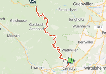
Ruta Bici de carretera de 23 km a descubrir en Gran Este, Alto Rin, Cernay. Esta ruta ha sido propuesta por nadd73.
Descripción
Départ de Uffholtz.
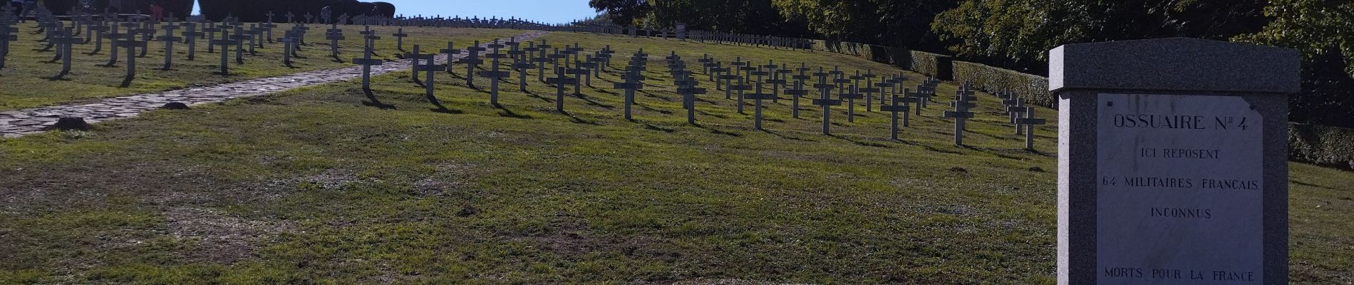
Visite du mémorial de Hatmannswiller
J'ai fait un aller retour.
Donc compter 50km et 1400 de dénivelé.
Localización
País:
France
Región :
Gran Este
Departamento/provincia :
Alto Rin
Municipio :
Cernay
Localidad:
Unknown
Salida:(Dec)
Salida:(UTM)
363220 ; 5296852 (32T) N.
Comentarios
Excursiones cerca
![Excursión Otra actividad Steinbach - lac du ballon - Photo](https://media.geolcdn.com/t/375/260/ext.jpg?maxdim=2&url=https%3A%2F%2Fservices.sitytrail.com%2FGeolivesWS%2FDownloadMedia.ashx%3FTrailID%3D210434%26Media%3Dfix__20130805111422.jpg)
![Otra actividad Otra actividad](https://static1.geolcdn.com/sitytour/trail-icons/900.png)
lac du ballon
Otra actividad
Muy fácil
(1)
Steinbach,
Gran Este,
Alto Rin,
France
![](/images/other/stat-length.png)
33 km | 64 km-effort
5h 1min
![](https://static1.geolcdn.com/siteimages/upload/files/16400158638029165_repeat_loop_refresh_sync_direction_icon.png)
No
![Excursión Senderismo Steinbach - Cascade de Erzenbach - Photo](https://media.geolcdn.com/t/375/260/069cb34c-c699-4fdf-8c9c-4524251a300c.jpg&format=jpg&maxdim=2)
![Senderismo Senderismo](https://static1.geolcdn.com/sitytour/trail-icons/101.png)
Cascade de Erzenbach
Senderismo
Medio
Steinbach,
Gran Este,
Alto Rin,
France
![](/images/other/stat-length.png)
6 km | 8,8 km-effort
1h 32min
![](https://static1.geolcdn.com/siteimages/upload/files/16400158638029165_repeat_loop_refresh_sync_direction_icon.png)
Sí
![Excursión Senderismo Uffholtz - Molkenrain 1 - Photo](https://media.geolcdn.com/t/375/260/ext.jpg?maxdim=2&url=https%3A%2F%2Fstatic1.geolcdn.com%2Fsiteimages%2Fupload%2Ffiles%2F1553511878bg_sport_marche.png)
![Senderismo Senderismo](https://static1.geolcdn.com/sitytour/trail-icons/101.png)
Molkenrain 1
Senderismo
Difícil
(1)
Uffholtz,
Gran Este,
Alto Rin,
France
![](/images/other/stat-length.png)
15,4 km | 26 km-effort
4h 0min
![](https://static1.geolcdn.com/siteimages/upload/files/16400158638029165_repeat_loop_refresh_sync_direction_icon.png)
Sí
![Excursión Senderismo Steinbach - Rando CLAS du 02/11/2023 - Photo](https://media.geolcdn.com/t/375/260/b250b3db-11e3-4a80-8674-092c6f8f5747.jpg&format=jpg&maxdim=2)
![Senderismo Senderismo](https://static1.geolcdn.com/sitytour/trail-icons/101.png)
Rando CLAS du 02/11/2023
Senderismo
Muy difícil
Steinbach,
Gran Este,
Alto Rin,
France
![](/images/other/stat-length.png)
17,7 km | 27 km-effort
4h 35min
![](https://static1.geolcdn.com/siteimages/upload/files/16400158638029165_repeat_loop_refresh_sync_direction_icon.png)
Sí
![Excursión Senderismo Steinbach - Rando Marcheurs du 03/07/2023 par ALAIN - Photo](https://media.geolcdn.com/t/375/260/4e0cdd43-ea09-40bc-a35d-76ad16a35005.jpg&format=jpg&maxdim=2)
![Senderismo Senderismo](https://static1.geolcdn.com/sitytour/trail-icons/101.png)
Rando Marcheurs du 03/07/2023 par ALAIN
Senderismo
Muy difícil
Steinbach,
Gran Este,
Alto Rin,
France
![](/images/other/stat-length.png)
20 km | 34 km-effort
5h 1min
![](https://static1.geolcdn.com/siteimages/upload/files/16400158638029165_repeat_loop_refresh_sync_direction_icon.png)
Sí
![Excursión Senderismo Wattwiller - Wattwiller - Domaine du Hirtz (30/03/2023) - Photo](https://media.geolcdn.com/t/375/260/fba38f94-41c6-40ad-89c3-14f41fe23918.jpg&format=jpg&maxdim=2)
![Senderismo Senderismo](https://static1.geolcdn.com/sitytour/trail-icons/101.png)
Wattwiller - Domaine du Hirtz (30/03/2023)
Senderismo
Fácil
Wattwiller,
Gran Este,
Alto Rin,
France
![](/images/other/stat-length.png)
6,1 km | 9,9 km-effort
2h 7min
![](https://static1.geolcdn.com/siteimages/upload/files/16400158638029165_repeat_loop_refresh_sync_direction_icon.png)
Sí
![Excursión Senderismo Uffholtz - Uffholtz - Wattwiller (23/12/2021) - Photo](https://media.geolcdn.com/t/375/260/02070a0c-7a17-415b-bc7b-c02ebf50cee2.jpg&format=jpg&maxdim=2)
![Senderismo Senderismo](https://static1.geolcdn.com/sitytour/trail-icons/101.png)
Uffholtz - Wattwiller (23/12/2021)
Senderismo
Medio
Uffholtz,
Gran Este,
Alto Rin,
France
![](/images/other/stat-length.png)
11,4 km | 17,2 km-effort
3h 27min
![](https://static1.geolcdn.com/siteimages/upload/files/16400158638029165_repeat_loop_refresh_sync_direction_icon.png)
Sí
![Excursión Bici de montaña Steinbach - Terrasse de Steinbach - Photo](https://media.geolcdn.com/t/375/260/808ad124-c44a-4a16-9370-b115d7d7eb8d.jpg&format=jpg&maxdim=2)
![Bici de montaña Bici de montaña](https://static1.geolcdn.com/sitytour/trail-icons/202.png)
Terrasse de Steinbach
Bici de montaña
Medio
Steinbach,
Gran Este,
Alto Rin,
France
![](/images/other/stat-length.png)
21 km | 30 km-effort
1h 53min
![](https://static1.geolcdn.com/siteimages/upload/files/16400158638029165_repeat_loop_refresh_sync_direction_icon.png)
Sí
![Excursión Senderismo Steinbach - steinbach, waldkapelle, vieux thann - Photo](https://media.geolcdn.com/t/375/260/ext.jpg?maxdim=2&url=https%3A%2F%2Fstatic1.geolcdn.com%2Fsiteimages%2Fupload%2Ffiles%2F1553511878bg_sport_marche.png)
![Senderismo Senderismo](https://static1.geolcdn.com/sitytour/trail-icons/101.png)
steinbach, waldkapelle, vieux thann
Senderismo
Fácil
(1)
Steinbach,
Gran Este,
Alto Rin,
France
![](/images/other/stat-length.png)
9 km | 13,4 km-effort
2h 36min
![](https://static1.geolcdn.com/siteimages/upload/files/16400158638029165_repeat_loop_refresh_sync_direction_icon.png)
Sí