![](/images/other/stat-length.png)
![Excursión Senderismo Cozzano - Ma Mare a Mare Centre étape 4: de Cozzano vers Catastaghju - Photo](https://media.geolcdn.com/t/1900/400/ext.pjpeg?maxdim=2&url=https%3A%2F%2Fservices.sitytrail.com%2FGeolivesWS%2FDownloadMedia.ashx%3FTrailID%3D339928%26Media%3D20140822144425.jpg)
Ma Mare a Mare Centre étape 4: de Cozzano vers Catastaghju
Vadim
Usuario
![Longitud](/images/other/stat-length.png)
![Altitud máxima](https://static1.geolcdn.com/siteimages/upload/files/1508320355ic_sort_altitude_max_24dp.png)
![Desnivel positivo](https://static1.geolcdn.com/siteimages/upload/files/1508320355ic_sort_den_pos_24dp.png)
![Km-Effort](/images/other/stat-length.png)
![Altitud mínima](https://static1.geolcdn.com/siteimages/upload/files/1508320355ic_sort_altitude_min_24dp.png)
![Desnivel negativo](https://static1.geolcdn.com/siteimages/upload/files/1508320355ic_sort_den_neg_24dp.png)
![Boucle](https://static1.geolcdn.com/siteimages/upload/files/16400158638029165_repeat_loop_refresh_sync_direction_icon.png)
![Senderismo](https://static1.geolcdn.com/sitytour/trail-icons/101.png)
6h26
Dificultad : Muy difícil
![Escanee este código QR para abrir la excursión en la aplicación SityTrail](https://capi.geolives.com/qq0zvz2zws4bq2lad0pu/sitytour/trails/339928/qr.png?size=200)
Aplicación GPS de excursión GRATIS
A propósito
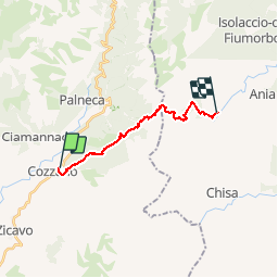
Ruta Senderismo de 19,6 km a descubrir en Córcega, Córcega del Sur, Cozzano. Esta ruta ha sido propuesta por Vadim.
Descripción
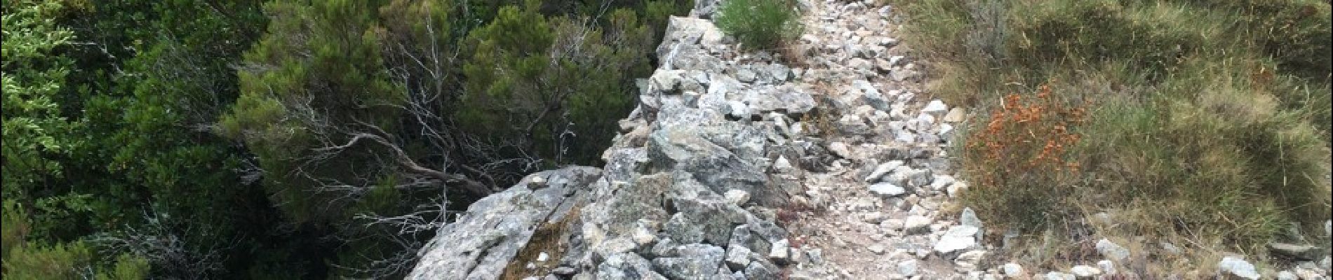
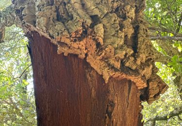
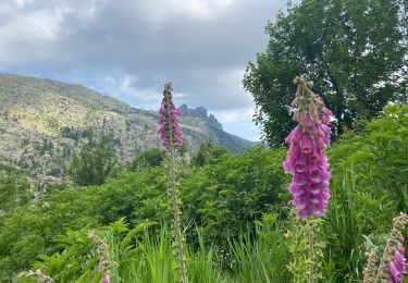
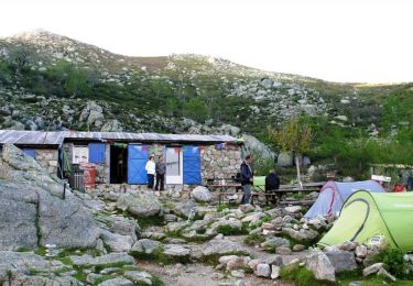
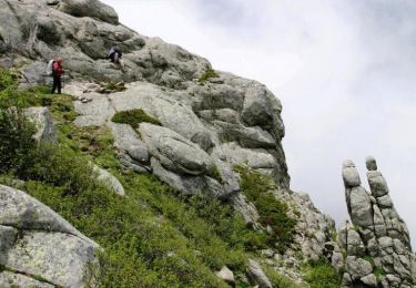
Catastaghju est rattachée à San Gavino di Fiumorbo. Etape difficile, surtout dans les descentes. Sur le col de Bocca di Laparo, au croisement de la Mare a Mare Centre et du GR20 à 1525 m, on peut voir la mer côté Ouest et la mer côté Est, avec Ghisonaccia et Serra di Fiumorbo, mais deux prochaine étape que je vais essayer de faire dans la même journée. Deux curiosité pendant la descente. La bergerie de la Scanciatella, qui est visitable, pensez à bien refermer la porte. Et Laparo, le chemin, qui était en son temps une route faites par un industriel négociant de bois. C'est ouvrage est presque en ruine, mais souvent on voit bien le travail qui à été fait. C'est pour moi un des points forts de la Mare a Mare Centre.
Localización
Comentarios
Excursiones cerca
![Excursión sport Cozzano - Mara Mar, centre, 2024, Journé, trois Guittera, les bains et les bains de Guittera - Photo](https://media.geolcdn.com/t/375/260/806c98b4-1e50-418c-b30f-e4ad9ebfaf2a.jpg&format=jpg&maxdim=2)
sport
![](/images/other/stat-length.png)
![](https://static1.geolcdn.com/siteimages/upload/files/16400158638029165_repeat_loop_refresh_sync_direction_icon.png)
![Excursión Senderismo Cozzano - Usciulu a Sinaï - Photo](https://media.geolcdn.com/t/375/260/a40d59c1-ea98-4ccf-a171-b077efb2e26a.jpg&format=jpg&maxdim=2)
![Senderismo Senderismo](https://static1.geolcdn.com/sitytour/trail-icons/101.png)
Senderismo
![](/images/other/stat-length.png)
![](https://static1.geolcdn.com/siteimages/upload/files/16400158638029165_repeat_loop_refresh_sync_direction_icon.png)
![Excursión Senderismo Cozzano - gr 20 sud 4 ème jour - Photo](https://media.geolcdn.com/t/375/260/ext.jpg?maxdim=2&url=https%3A%2F%2Fservices.sitytrail.com%2FGeolivesWS%2FDownloadMedia.ashx%3FTrailID%3D984130%26Media%3Dfix__20180604150534.jpg)
![Senderismo Senderismo](https://static1.geolcdn.com/sitytour/trail-icons/101.png)
Senderismo
![](/images/other/stat-length.png)
![](https://static1.geolcdn.com/siteimages/upload/files/16400158638029165_repeat_loop_refresh_sync_direction_icon.png)
![Excursión Senderismo Cozzano - Liaison du refuge d'Usciolu au refuge d'Asinau - Etape 13 - Photo](https://media.geolcdn.com/t/375/260/ext.jpg?maxdim=2&url=https%3A%2F%2Fstatic1.geolcdn.com%2Fsiteimages%2Fupload%2Ffiles%2F1553511878bg_sport_marche.png)
![Senderismo Senderismo](https://static1.geolcdn.com/sitytour/trail-icons/101.png)
Senderismo
![](/images/other/stat-length.png)
![](https://static1.geolcdn.com/siteimages/upload/files/16400158638029165_repeat_loop_refresh_sync_direction_icon.png)
![Excursión Senderismo Cozzano - GR20 Corse étape 13 - Photo](https://media.geolcdn.com/t/375/260/6087407c-ba34-41fa-ba65-90708866db3c.jpg&format=jpg&maxdim=2)
![Senderismo Senderismo](https://static1.geolcdn.com/sitytour/trail-icons/101.png)
Senderismo
![](/images/other/stat-length.png)
![](https://static1.geolcdn.com/siteimages/upload/files/16400158638029165_repeat_loop_refresh_sync_direction_icon.png)
![Excursión Senderismo Cozzano - GR20 Etape 13 Usciolu Bergerie d'Asinau - Photo](https://media.geolcdn.com/t/375/260/46e1ceca-c0be-438f-895d-408ffbc9448b.jpg&format=jpg&maxdim=2)
![Senderismo Senderismo](https://static1.geolcdn.com/sitytour/trail-icons/101.png)
Senderismo
![](/images/other/stat-length.png)
![](https://static1.geolcdn.com/siteimages/upload/files/16400158638029165_repeat_loop_refresh_sync_direction_icon.png)
![Excursión Senderismo Zicavo - GR 20® Liaison de Bocca di l'Agnone à Zicavu - Photo](https://media.geolcdn.com/t/375/260/ext.jpg?maxdim=2&url=https%3A%2F%2Fservices.sitytrail.com%2FGeolivesWS%2FDownloadMedia.ashx%3FTrailID%3D316745%26Media%3D4658_1.jpg)
![Senderismo Senderismo](https://static1.geolcdn.com/sitytour/trail-icons/101.png)
Senderismo
![](/images/other/stat-length.png)
![](https://static1.geolcdn.com/siteimages/upload/files/16400158638029165_repeat_loop_refresh_sync_direction_icon.png)
![Excursión Senderismo Cozzano - GR 20® du refuge d'Usciolu au refuge d'Asinau - Photo](https://media.geolcdn.com/t/375/260/ext.jpg?maxdim=2&url=https%3A%2F%2Fservices.sitytrail.com%2FGeolivesWS%2FDownloadMedia.ashx%3FTrailID%3D316744%26Media%3D4657_2.jpg)
![Senderismo Senderismo](https://static1.geolcdn.com/sitytour/trail-icons/101.png)
Senderismo
![](/images/other/stat-length.png)
![](https://static1.geolcdn.com/siteimages/upload/files/16400158638029165_repeat_loop_refresh_sync_direction_icon.png)
![Excursión Senderismo Cozzano - GR 20® Liaison du refuge d'Usciolu à Cozzano - Photo](https://media.geolcdn.com/t/375/260/ext.jpg?maxdim=2&url=https%3A%2F%2Fservices.sitytrail.com%2FGeolivesWS%2FDownloadMedia.ashx%3FTrailID%3D316743%26Media%3D4656_1.jpg)
![Senderismo Senderismo](https://static1.geolcdn.com/sitytour/trail-icons/101.png)
Senderismo
![](/images/other/stat-length.png)
![](https://static1.geolcdn.com/siteimages/upload/files/16400158638029165_repeat_loop_refresh_sync_direction_icon.png)