![](/images/other/stat-length.png)
![Excursión Senderismo Leucate - Leucate - Photo](https://media.geolcdn.com/t/1900/400/ext.pjpeg?maxdim=2&url=https%3A%2F%2Fstatic1.geolcdn.com%2Fsiteimages%2Fupload%2Ffiles%2F1553511878bg_sport_marche.png)
Leucate
nandaf
Usuario
![Longitud](/images/other/stat-length.png)
Longitud
8,9 km
![Altitud máxima](https://static1.geolcdn.com/siteimages/upload/files/1508320355ic_sort_altitude_max_24dp.png)
Altitud máxima
58 m
![Desnivel positivo](https://static1.geolcdn.com/siteimages/upload/files/1508320355ic_sort_den_pos_24dp.png)
Desnivel positivo
108 m
![Km-Effort](/images/other/stat-length.png)
Km-Effort
10,4 km
![Altitud mínima](https://static1.geolcdn.com/siteimages/upload/files/1508320355ic_sort_altitude_min_24dp.png)
Altitud mínima
1 m
![Desnivel negativo](https://static1.geolcdn.com/siteimages/upload/files/1508320355ic_sort_den_neg_24dp.png)
Desnivel negativo
112 m
![Boucle](https://static1.geolcdn.com/siteimages/upload/files/16400158638029165_repeat_loop_refresh_sync_direction_icon.png)
Boucle
Sí
Fecha de creación :
2022-09-20 13:12:41.0
Última modificación :
2024-04-20 14:53:06.636
![Senderismo](https://static1.geolcdn.com/sitytour/trail-icons/101.png)
2h58
Dificultad : Desconocido
![Escanee este código QR para abrir la excursión en la aplicación SityTrail](https://capi.geolives.com/qq0zvz2zws4bq2lad0pu/sitytour/trails/3398168/qr.png?size=200)
Aplicación GPS de excursión GRATIS
A propósito
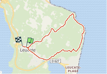
Ruta Senderismo de 8,9 km a descubrir en Occitania, Aude, Leucate. Esta ruta ha sido propuesta por nandaf.
Descripción
Boucle en partant du village de Leucate.
On longera les falaises de Leucate avec une belle vue sur la mer
Localización
País:
France
Región :
Occitania
Departamento/provincia :
Aude
Municipio :
Leucate
Localidad:
Unknown
Salida:(Dec)
Salida:(UTM)
502145 ; 4750954 (31T) N.
Comentarios
Excursiones cerca
![Excursión Senderismo Leucate - mon sentier des pêcheurs - Photo](https://media.geolcdn.com/t/375/260/d041d0df-07da-4421-a9ea-d982392d3e0c.jpg&format=jpg&maxdim=2)
![Senderismo Senderismo](https://static1.geolcdn.com/sitytour/trail-icons/101.png)
mon sentier des pêcheurs
Senderismo
Muy fácil
(1)
Leucate,
Occitania,
Aude,
France
![](/images/other/stat-length.png)
5,6 km | 6,5 km-effort
2h 7min
![](https://static1.geolcdn.com/siteimages/upload/files/16400158638029165_repeat_loop_refresh_sync_direction_icon.png)
Sí
![Excursión Senderismo Leucate - Leucate village - Photo](https://media.geolcdn.com/t/375/260/ext.jpg?maxdim=2&url=https%3A%2F%2Fservices.sitytrail.com%2FGeolivesWS%2FDownloadMedia.ashx%3FTrailID%3D179085%26Media%3Df1524f36-0682-4bf6-975a-882cd23421f5.JPG)
![Senderismo Senderismo](https://static1.geolcdn.com/sitytour/trail-icons/101.png)
Leucate village
Senderismo
Medio
(2)
Leucate,
Occitania,
Aude,
France
![](/images/other/stat-length.png)
7 km | 8,2 km-effort
1h 46min
![](https://static1.geolcdn.com/siteimages/upload/files/16400158638029165_repeat_loop_refresh_sync_direction_icon.png)
Sí
![Excursión Bici de montaña Leucate - Leucate sur un plateau ! - Photo](https://media.geolcdn.com/t/375/260/ext.jpg?maxdim=2&url=https%3A%2F%2Fservices.sitytrail.com%2FGeolivesWS%2FDownloadMedia.ashx%3FTrailID%3D100672%26Media%3D196_3.jpg)
![Bici de montaña Bici de montaña](https://static1.geolcdn.com/sitytour/trail-icons/202.png)
Leucate sur un plateau !
Bici de montaña
Fácil
(1)
Leucate,
Occitania,
Aude,
France
![](/images/other/stat-length.png)
10,8 km | 12,4 km-effort
45min
![](https://static1.geolcdn.com/siteimages/upload/files/16400158638029165_repeat_loop_refresh_sync_direction_icon.png)
No
![Excursión Bici de montaña Leucate - VTT Leucate La Palme - Photo](https://media.geolcdn.com/t/375/260/f6afc4d0-f8dc-4d8d-bdc2-3236cac7bfec.jpg&format=jpg&maxdim=2)
![Bici de montaña Bici de montaña](https://static1.geolcdn.com/sitytour/trail-icons/202.png)
VTT Leucate La Palme
Bici de montaña
Fácil
(1)
Leucate,
Occitania,
Aude,
France
![](/images/other/stat-length.png)
29 km | 32 km-effort
2h 10min
![](https://static1.geolcdn.com/siteimages/upload/files/16400158638029165_repeat_loop_refresh_sync_direction_icon.png)
Sí
![Excursión Senderismo Leucate - Leucate Sentier du guetteur+ château - Photo](https://media.geolcdn.com/t/375/260/0d9f9422-d3ba-4f9e-b0b9-30df507d067c.jpg&format=jpg&maxdim=2)
![Senderismo Senderismo](https://static1.geolcdn.com/sitytour/trail-icons/101.png)
Leucate Sentier du guetteur+ château
Senderismo
Medio
Leucate,
Occitania,
Aude,
France
![](/images/other/stat-length.png)
18,4 km | 21 km-effort
6h 2min
![](https://static1.geolcdn.com/siteimages/upload/files/16400158638029165_repeat_loop_refresh_sync_direction_icon.png)
Sí
![Excursión Senderismo Leucate - plateau leucate - sud est - Photo](https://media.geolcdn.com/t/375/260/fc551c80-a7a1-459f-83d9-ef8bc94cafd9.jpg&format=jpg&maxdim=2)
![Senderismo Senderismo](https://static1.geolcdn.com/sitytour/trail-icons/101.png)
plateau leucate - sud est
Senderismo
Fácil
Leucate,
Occitania,
Aude,
France
![](/images/other/stat-length.png)
11,1 km | 13 km-effort
3h 23min
![](https://static1.geolcdn.com/siteimages/upload/files/16400158638029165_repeat_loop_refresh_sync_direction_icon.png)
Sí
![Excursión Senderismo Leucate - leucate - cap des frères (sentier des bergers) -la franqui (sentier des guetteurs) - leucate (se tier des vignerons) - Photo](https://media.geolcdn.com/t/375/260/5389bc4c-6ebc-475a-8eed-23be4124a740.jpg&format=jpg&maxdim=2)
![Senderismo Senderismo](https://static1.geolcdn.com/sitytour/trail-icons/101.png)
leucate - cap des frères (sentier des bergers) -la franqui (sentier des guett...
Senderismo
Difícil
Leucate,
Occitania,
Aude,
France
![](/images/other/stat-length.png)
10,6 km | 12,5 km-effort
4h 22min
![](https://static1.geolcdn.com/siteimages/upload/files/16400158638029165_repeat_loop_refresh_sync_direction_icon.png)
Sí
![Excursión Senderismo Leucate - 2023-02-03_17h08m34_SityTrail - 3539502 - leucate-plateau-chemin-vigneronx-franquix-le-fort-xcao-frerex-semaphore - Photo](https://media.geolcdn.com/t/375/260/ext.jpg?maxdim=2&url=https%3A%2F%2Fstatic1.geolcdn.com%2Fsiteimages%2Fupload%2Ffiles%2F1553511878bg_sport_marche.png)
![Senderismo Senderismo](https://static1.geolcdn.com/sitytour/trail-icons/101.png)
2023-02-03_17h08m34_SityTrail - 3539502 - leucate-plateau-chemin-vigneronx-fr...
Senderismo
Fácil
(1)
Leucate,
Occitania,
Aude,
France
![](/images/other/stat-length.png)
10,1 km | 12,3 km-effort
2h 47min
![](https://static1.geolcdn.com/siteimages/upload/files/16400158638029165_repeat_loop_refresh_sync_direction_icon.png)
Sí
![Excursión Senderismo Leucate - Leucate château falaise - Photo](https://media.geolcdn.com/t/375/260/3cce4778-81ed-4254-af5e-b0b5f1ccbabf.jpg&format=jpg&maxdim=2)
![Senderismo Senderismo](https://static1.geolcdn.com/sitytour/trail-icons/101.png)
Leucate château falaise
Senderismo
Muy fácil
Leucate,
Occitania,
Aude,
France
![](/images/other/stat-length.png)
15,2 km | 17,8 km-effort
3h 31min
![](https://static1.geolcdn.com/siteimages/upload/files/16400158638029165_repeat_loop_refresh_sync_direction_icon.png)
Sí