![](/images/other/stat-length.png)
![Excursión Senderismo Bangor - 3-Port Coton - Locmaria à Belle Île en mer - Photo](https://media.geolcdn.com/t/1900/400/61d9dfb6-e967-452b-8601-de89fcd53ae3.jpg&format=pjpeg&maxdim=2)
3-Port Coton - Locmaria à Belle Île en mer
meunier.ph.
Usuario
![Longitud](/images/other/stat-length.png)
Longitud
25 km
![Altitud máxima](https://static1.geolcdn.com/siteimages/upload/files/1508320355ic_sort_altitude_max_24dp.png)
Altitud máxima
53 m
![Desnivel positivo](https://static1.geolcdn.com/siteimages/upload/files/1508320355ic_sort_den_pos_24dp.png)
Desnivel positivo
561 m
![Km-Effort](/images/other/stat-length.png)
Km-Effort
33 km
![Altitud mínima](https://static1.geolcdn.com/siteimages/upload/files/1508320355ic_sort_altitude_min_24dp.png)
Altitud mínima
5 m
![Desnivel negativo](https://static1.geolcdn.com/siteimages/upload/files/1508320355ic_sort_den_neg_24dp.png)
Desnivel negativo
534 m
![Boucle](https://static1.geolcdn.com/siteimages/upload/files/16400158638029165_repeat_loop_refresh_sync_direction_icon.png)
Boucle
No
Fecha de creación :
2022-09-14 07:45:15.415
Última modificación :
2022-09-17 16:49:29.809
![Senderismo](https://static1.geolcdn.com/sitytour/trail-icons/101.png)
5h05
Dificultad : Medio
![Escanee este código QR para abrir la excursión en la aplicación SityTrail](https://capi.geolives.com/qq0zvz2zws4bq2lad0pu/sitytour/trails/3390841/qr.png?size=200)
Aplicación GPS de excursión GRATIS
A propósito
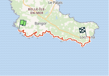
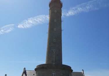
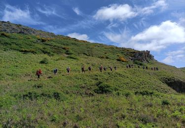
Ruta Senderismo de 25 km a descubrir en Bretaña, Morbihan, Bangor. Esta ruta ha sido propuesta por meunier.ph..
Descripción
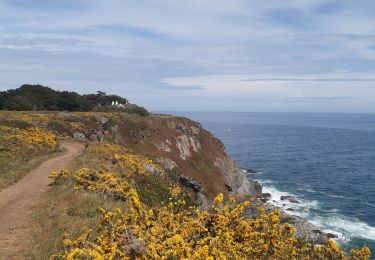
Départ du Palais par le bus jusqu'à Port Coton et retour en bus de Locmaria au Palais.
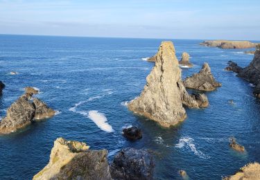
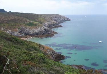
Côte sauvage très découpée à Port Coton avec ses aiguilles renommées.
Localización
País:
France
Región :
Bretaña
Departamento/provincia :
Morbihan
Municipio :
Bangor
Localidad:
Unknown
Salida:(Dec)
Salida:(UTM)
482039 ; 5239090 (30T) N.
Comentarios
Excursiones cerca
![Excursión Senderismo Bangor - bangor - Photo](https://media.geolcdn.com/t/375/260/ext.jpg?maxdim=2&url=https%3A%2F%2Fservices.sitytrail.com%2FGeolivesWS%2FDownloadMedia.ashx%3FTrailID%3D308558%26Media%3Dfix__20140530104824.jpg)
![Senderismo Senderismo](https://static1.geolcdn.com/sitytour/trail-icons/101.png)
bangor
Senderismo
Muy fácil
(1)
Bangor,
Bretaña,
Morbihan,
France
![](/images/other/stat-length.png)
9,4 km | 11,2 km-effort
2h 40min
![](https://static1.geolcdn.com/siteimages/upload/files/16400158638029165_repeat_loop_refresh_sync_direction_icon.png)
Sí
![Excursión Senderismo Bangor - Belle île en mer - Photo](https://media.geolcdn.com/t/375/260/3a7f4183-98be-4dc7-9aad-ed1e320f25b2.jpg&format=jpg&maxdim=2)
![Senderismo Senderismo](https://static1.geolcdn.com/sitytour/trail-icons/101.png)
Belle île en mer
Senderismo
Muy difícil
Bangor,
Bretaña,
Morbihan,
France
![](/images/other/stat-length.png)
64 km | 82 km-effort
15h 44min
![](https://static1.geolcdn.com/siteimages/upload/files/16400158638029165_repeat_loop_refresh_sync_direction_icon.png)
No
![Excursión Senderismo Bangor - J3 - Port Coton - Locmaria - 24 km - Photo](https://media.geolcdn.com/t/375/260/ext.jpg?maxdim=2&url=https%3A%2F%2Fstatic1.geolcdn.com%2Fsiteimages%2Fupload%2Ffiles%2F1553511878bg_sport_marche.png)
![Senderismo Senderismo](https://static1.geolcdn.com/sitytour/trail-icons/101.png)
J3 - Port Coton - Locmaria - 24 km
Senderismo
Muy difícil
(1)
Bangor,
Bretaña,
Morbihan,
France
![](/images/other/stat-length.png)
24 km | 31 km-effort
7h 3min
![](https://static1.geolcdn.com/siteimages/upload/files/16400158638029165_repeat_loop_refresh_sync_direction_icon.png)
No
![Excursión Senderismo Bangor - 2-Port Coton - l'Apothicairerie à Belle Île en mer - Photo](https://media.geolcdn.com/t/375/260/5b3aba3d-6201-477b-b54e-bfc76b8e3758.jpg&format=jpg&maxdim=2)
![Senderismo Senderismo](https://static1.geolcdn.com/sitytour/trail-icons/101.png)
2-Port Coton - l'Apothicairerie à Belle Île en mer
Senderismo
Medio
Bangor,
Bretaña,
Morbihan,
France
![](/images/other/stat-length.png)
13,7 km | 17,2 km-effort
2h 50min
![](https://static1.geolcdn.com/siteimages/upload/files/16400158638029165_repeat_loop_refresh_sync_direction_icon.png)
No
![Excursión Senderismo Bangor - GR340 BELLE-ILE jour 3 - Grand Large - Locmaria - Photo](https://media.geolcdn.com/t/375/260/8b1423fb-d98c-4bac-8258-679bd03de44c.jpg&format=jpg&maxdim=2)
![Senderismo Senderismo](https://static1.geolcdn.com/sitytour/trail-icons/101.png)
GR340 BELLE-ILE jour 3 - Grand Large - Locmaria
Senderismo
Difícil
Bangor,
Bretaña,
Morbihan,
France
![](/images/other/stat-length.png)
25 km | 32 km-effort
8h 5min
![](https://static1.geolcdn.com/siteimages/upload/files/16400158638029165_repeat_loop_refresh_sync_direction_icon.png)
No
![Excursión Senderismo Bangor - aiguilles de port Cotton - Photo](https://media.geolcdn.com/t/375/260/351bb440-7c45-45af-8626-d2213c10b99a.jpg&format=jpg&maxdim=2)
![Senderismo Senderismo](https://static1.geolcdn.com/sitytour/trail-icons/101.png)
aiguilles de port Cotton
Senderismo
Fácil
Bangor,
Bretaña,
Morbihan,
France
![](/images/other/stat-length.png)
6,6 km | 7,9 km-effort
2h 3min
![](https://static1.geolcdn.com/siteimages/upload/files/16400158638029165_repeat_loop_refresh_sync_direction_icon.png)
Sí
![Excursión A pie Bangor - Sentier du Stang Per - Photo](https://media.geolcdn.com/t/375/260/79d44e98-b1d5-40ac-81c7-6fc59deba8b2.jpeg&format=jpg&maxdim=2)
![A pie A pie](https://static1.geolcdn.com/sitytour/trail-icons/100.png)
![Excursión Senderismo Bangor - port cotton,Locmaria - Photo](https://media.geolcdn.com/t/375/260/8341e71a-a817-404b-9455-cd0135701718.jpg&format=jpg&maxdim=2)
![Senderismo Senderismo](https://static1.geolcdn.com/sitytour/trail-icons/101.png)
port cotton,Locmaria
Senderismo
Medio
Bangor,
Bretaña,
Morbihan,
France
![](/images/other/stat-length.png)
19,6 km | 26 km-effort
5h 11min
![](https://static1.geolcdn.com/siteimages/upload/files/16400158638029165_repeat_loop_refresh_sync_direction_icon.png)
No
![Excursión Marcha nórdica Bangor - troisième étape belle ile - Photo](https://media.geolcdn.com/t/375/260/bd435c70-a294-44ac-b3d3-11527cf6c943.jpg&format=jpg&maxdim=2)
![Marcha nórdica Marcha nórdica](https://static1.geolcdn.com/sitytour/trail-icons/102.png)
troisième étape belle ile
Marcha nórdica
Muy fácil
Bangor,
Bretaña,
Morbihan,
France
![](/images/other/stat-length.png)
38 km | 47 km-effort
6h 21min
![](https://static1.geolcdn.com/siteimages/upload/files/16400158638029165_repeat_loop_refresh_sync_direction_icon.png)
No