![](/images/other/stat-length.png)
![Excursión Senderismo Beaumont-du-Ventoux - Boucle Ventoux - Photo](https://media.geolcdn.com/t/1900/400/ext.pjpeg?maxdim=2&url=https%3A%2F%2Fstatic1.geolcdn.com%2Fsiteimages%2Fupload%2Ffiles%2F1553511878bg_sport_marche.png)
Boucle Ventoux
makounet
Usuario
![Longitud](/images/other/stat-length.png)
Longitud
23 km
![Altitud máxima](https://static1.geolcdn.com/siteimages/upload/files/1508320355ic_sort_altitude_max_24dp.png)
Altitud máxima
1902 m
![Desnivel positivo](https://static1.geolcdn.com/siteimages/upload/files/1508320355ic_sort_den_pos_24dp.png)
Desnivel positivo
1121 m
![Km-Effort](/images/other/stat-length.png)
Km-Effort
38 km
![Altitud mínima](https://static1.geolcdn.com/siteimages/upload/files/1508320355ic_sort_altitude_min_24dp.png)
Altitud mínima
1349 m
![Desnivel negativo](https://static1.geolcdn.com/siteimages/upload/files/1508320355ic_sort_den_neg_24dp.png)
Desnivel negativo
1119 m
![Boucle](https://static1.geolcdn.com/siteimages/upload/files/16400158638029165_repeat_loop_refresh_sync_direction_icon.png)
Boucle
Sí
Fecha de creación :
2014-12-10 00:00:00.0
Última modificación :
2014-12-10 00:00:00.0
![Senderismo](https://static1.geolcdn.com/sitytour/trail-icons/101.png)
8h15
Dificultad : Fácil
![Escanee este código QR para abrir la excursión en la aplicación SityTrail](https://capi.geolives.com/qq0zvz2zws4bq2lad0pu/sitytour/trails/339053/qr.png?size=200)
Aplicación GPS de excursión GRATIS
A propósito
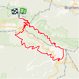
Ruta Senderismo de 23 km a descubrir en Provenza-Alpes-Costa Azul, Vaucluse, Beaumont-du-Ventoux. Esta ruta ha sido propuesta por makounet.
Descripción
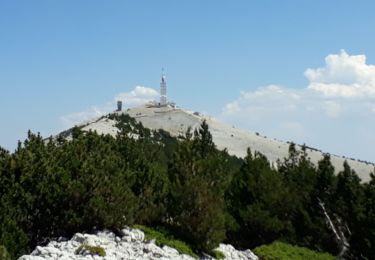
Le tour du Mont-Ventoux. Départ Mont-Serein, GR9, Chalet Reynard, Jas des pèlerins, sommet puis GR4 pour redescendre au Mont-Serein.
Localización
País:
France
Región :
Provenza-Alpes-Costa Azul
Departamento/provincia :
Vaucluse
Municipio :
Beaumont-du-Ventoux
Localidad:
Unknown
Salida:(Dec)
Salida:(UTM)
681818 ; 4894922 (31T) N.
Comentarios
Excursiones cerca
![Excursión Senderismo Beaumont-du-Ventoux - Le Ventoux - Corniche Nord - Photo](https://media.geolcdn.com/t/375/260/ext.jpg?maxdim=2&url=https%3A%2F%2Fservices.sitytrail.com%2FGeolivesWS%2FDownloadMedia.ashx%3FTrailID%3D105329%26Media%3D9023_2.jpg)
![Senderismo Senderismo](https://static1.geolcdn.com/sitytour/trail-icons/101.png)
Le Ventoux - Corniche Nord
Senderismo
Difícil
(2)
Beaumont-du-Ventoux,
Provenza-Alpes-Costa Azul,
Vaucluse,
France
![](/images/other/stat-length.png)
19,1 km | 30 km-effort
6h 30min
![](https://static1.geolcdn.com/siteimages/upload/files/16400158638029165_repeat_loop_refresh_sync_direction_icon.png)
Sí
![Excursión Senderismo Beaumont-du-Ventoux - Sentier de découverte au Mont Serein - Photo](https://media.geolcdn.com/t/375/260/ext.jpg?maxdim=2&url=https%3A%2F%2Fservices.sitytrail.com%2FGeolivesWS%2FDownloadMedia.ashx%3FTrailID%3D103767%26Media%3D6520_2.jpg)
![Senderismo Senderismo](https://static1.geolcdn.com/sitytour/trail-icons/101.png)
Sentier de découverte au Mont Serein
Senderismo
Medio
(2)
Beaumont-du-Ventoux,
Provenza-Alpes-Costa Azul,
Vaucluse,
France
![](/images/other/stat-length.png)
6,3 km | 8,2 km-effort
2h 0min
![](https://static1.geolcdn.com/siteimages/upload/files/16400158638029165_repeat_loop_refresh_sync_direction_icon.png)
Sí
![Excursión Bici de montaña Bédoin - Enduro Lilou Collet de Robin - Photo](https://media.geolcdn.com/t/375/260/5b277d16-82be-4683-8302-c0071eeba31c.jpg&format=jpg&maxdim=2)
![Bici de montaña Bici de montaña](https://static1.geolcdn.com/sitytour/trail-icons/202.png)
Enduro Lilou Collet de Robin
Bici de montaña
Medio
Bédoin,
Provenza-Alpes-Costa Azul,
Vaucluse,
France
![](/images/other/stat-length.png)
23 km | 29 km-effort
2h 1min
![](https://static1.geolcdn.com/siteimages/upload/files/16400158638029165_repeat_loop_refresh_sync_direction_icon.png)
No
![Excursión Bici de montaña Bédoin - Enduro les Pins Noirs - Photo](https://media.geolcdn.com/t/375/260/2664f93b-d28f-4f7e-87bb-83b490384099.jpg&format=jpg&maxdim=2)
![Bici de montaña Bici de montaña](https://static1.geolcdn.com/sitytour/trail-icons/202.png)
Enduro les Pins Noirs
Bici de montaña
Difícil
Bédoin,
Provenza-Alpes-Costa Azul,
Vaucluse,
France
![](/images/other/stat-length.png)
37 km | 49 km-effort
2h 55min
![](https://static1.geolcdn.com/siteimages/upload/files/16400158638029165_repeat_loop_refresh_sync_direction_icon.png)
No
![Excursión Bici de montaña Bédoin - Enduro ventoux Jas de Roubin - Photo](https://media.geolcdn.com/t/375/260/1373ca7b-671b-4daf-87c8-1e173f3e01d8.jpg&format=jpg&maxdim=2)
![Bici de montaña Bici de montaña](https://static1.geolcdn.com/sitytour/trail-icons/202.png)
Enduro ventoux Jas de Roubin
Bici de montaña
Medio
Bédoin,
Provenza-Alpes-Costa Azul,
Vaucluse,
France
![](/images/other/stat-length.png)
23 km | 30 km-effort
2h 3min
![](https://static1.geolcdn.com/siteimages/upload/files/16400158638029165_repeat_loop_refresh_sync_direction_icon.png)
No
![Excursión Senderismo Bédoin - Les Glacières du Facteur - Photo](https://media.geolcdn.com/t/375/260/cb31eb20-4ac1-469f-8550-b7fec6b9125d.jpg&format=jpg&maxdim=2)
![Senderismo Senderismo](https://static1.geolcdn.com/sitytour/trail-icons/101.png)
Les Glacières du Facteur
Senderismo
Muy difícil
Bédoin,
Provenza-Alpes-Costa Azul,
Vaucluse,
France
![](/images/other/stat-length.png)
13,2 km | 21 km-effort
4h 43min
![](https://static1.geolcdn.com/siteimages/upload/files/16400158638029165_repeat_loop_refresh_sync_direction_icon.png)
Sí
![Excursión Senderismo Bédoin - sentier du Vertige - Photo](https://media.geolcdn.com/t/375/260/537c0036-295e-4148-b1ac-658565f4196a.jpg&format=jpg&maxdim=2)
![Senderismo Senderismo](https://static1.geolcdn.com/sitytour/trail-icons/101.png)
sentier du Vertige
Senderismo
Difícil
Bédoin,
Provenza-Alpes-Costa Azul,
Vaucluse,
France
![](/images/other/stat-length.png)
7,4 km | 12,3 km-effort
2h 54min
![](https://static1.geolcdn.com/siteimages/upload/files/16400158638029165_repeat_loop_refresh_sync_direction_icon.png)
Sí
![Excursión Senderismo Beaumont-du-Ventoux - Crêtes du Ventoux - Photo](https://media.geolcdn.com/t/375/260/91441923-a9c0-4765-9dda-d1eb9e281d5f.jpg&format=jpg&maxdim=2)
![Senderismo Senderismo](https://static1.geolcdn.com/sitytour/trail-icons/101.png)
Crêtes du Ventoux
Senderismo
Difícil
Beaumont-du-Ventoux,
Provenza-Alpes-Costa Azul,
Vaucluse,
France
![](/images/other/stat-length.png)
18,8 km | 29 km-effort
6h 4min
![](https://static1.geolcdn.com/siteimages/upload/files/16400158638029165_repeat_loop_refresh_sync_direction_icon.png)
Sí
![Excursión Senderismo Brantes - Ascencion du Ventoux sur 2 jours j1 - Photo](https://media.geolcdn.com/t/375/260/f9d58ab5-05c4-42e7-b010-c69a5ea3f997.jpg&format=jpg&maxdim=2)
![Senderismo Senderismo](https://static1.geolcdn.com/sitytour/trail-icons/101.png)
Ascencion du Ventoux sur 2 jours j1
Senderismo
Muy difícil
Brantes,
Provenza-Alpes-Costa Azul,
Vaucluse,
France
![](/images/other/stat-length.png)
22 km | 40 km-effort
8h 53min
![](https://static1.geolcdn.com/siteimages/upload/files/16400158638029165_repeat_loop_refresh_sync_direction_icon.png)
No