![](/images/other/stat-length.png)
![Excursión Senderismo Proveysieux - Planfay_Aiguille de Quaix - Photo](https://media.geolcdn.com/t/1900/400/1c9f0227-c803-4b34-a60c-63ca47bc45de.jpg&format=pjpeg&maxdim=2)
Planfay_Aiguille de Quaix
Mich&Agnès
Usuario
![Longitud](/images/other/stat-length.png)
Longitud
10,7 km
![Altitud máxima](https://static1.geolcdn.com/siteimages/upload/files/1508320355ic_sort_altitude_max_24dp.png)
Altitud máxima
1131 m
![Desnivel positivo](https://static1.geolcdn.com/siteimages/upload/files/1508320355ic_sort_den_pos_24dp.png)
Desnivel positivo
678 m
![Km-Effort](/images/other/stat-length.png)
Km-Effort
19,8 km
![Altitud mínima](https://static1.geolcdn.com/siteimages/upload/files/1508320355ic_sort_altitude_min_24dp.png)
Altitud mínima
736 m
![Desnivel negativo](https://static1.geolcdn.com/siteimages/upload/files/1508320355ic_sort_den_neg_24dp.png)
Desnivel negativo
674 m
![Boucle](https://static1.geolcdn.com/siteimages/upload/files/16400158638029165_repeat_loop_refresh_sync_direction_icon.png)
Boucle
Sí
Fecha de creación :
2022-09-12 09:38:51.655
Última modificación :
2022-09-18 08:53:17.862
![Senderismo](https://static1.geolcdn.com/sitytour/trail-icons/101.png)
4h30
Dificultad : Difícil
![Escanee este código QR para abrir la excursión en la aplicación SityTrail](https://capi.geolives.com/qq0zvz2zws4bq2lad0pu/sitytour/trails/3388805/qr.png?size=200)
Aplicación GPS de excursión GRATIS
A propósito
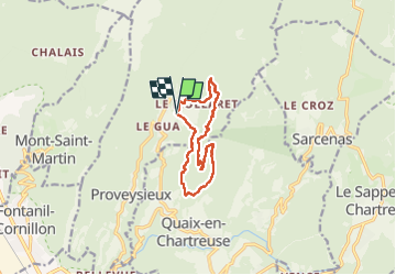
Ruta Senderismo de 10,7 km a descubrir en Auvergne-Rhône-Alpes, Isère, Proveysieux. Esta ruta ha sido propuesta por Mich&Agnès.
Descripción
Belle balade ombragée, attention la 1ere montée est redoutable pour les organismes et les articulations.
Le tour de l'aiguille se fait par la gauche
Localización
País:
France
Región :
Auvergne-Rhône-Alpes
Departamento/provincia :
Isère
Municipio :
Proveysieux
Localidad:
Unknown
Salida:(Dec)
Salida:(UTM)
712774 ; 5017529 (31T) N.
Comentarios
Excursiones cerca
![Excursión Senderismo Voreppe - Le Rocher de Lorzier, 1838m - Photo](https://media.geolcdn.com/t/375/260/ext.jpg?maxdim=2&url=https%3A%2F%2Fservices.sitytrail.com%2FGeolivesWS%2FDownloadMedia.ashx%3FTrailID%3D105680%26Media%3D9506_1.jpg)
![Senderismo Senderismo](https://static1.geolcdn.com/sitytour/trail-icons/101.png)
Le Rocher de Lorzier, 1838m
Senderismo
Medio
(2)
Voreppe,
Auvergne-Rhône-Alpes,
Isère,
France
![](/images/other/stat-length.png)
12,3 km | 25 km-effort
4h 45min
![](https://static1.geolcdn.com/siteimages/upload/files/16400158638029165_repeat_loop_refresh_sync_direction_icon.png)
Sí
![Excursión Senderismo Saint-Pierre-de-Chartreuse - Le Charmant Som depuis le Col de la Charmette - Photo](https://media.geolcdn.com/t/375/260/ext.jpg?maxdim=2&url=https%3A%2F%2Fservices.sitytrail.com%2FGeolivesWS%2FDownloadMedia.ashx%3FTrailID%3D104129%26Media%3D7202_1.jpg)
![Senderismo Senderismo](https://static1.geolcdn.com/sitytour/trail-icons/101.png)
Le Charmant Som depuis le Col de la Charmette
Senderismo
Medio
(2)
Saint-Pierre-de-Chartreuse,
Auvergne-Rhône-Alpes,
Isère,
France
![](/images/other/stat-length.png)
8,9 km | 17,3 km-effort
5h 0min
![](https://static1.geolcdn.com/siteimages/upload/files/16400158638029165_repeat_loop_refresh_sync_direction_icon.png)
Sí
![Excursión Senderismo Saint-Pierre-de-Chartreuse - Le Charmant Som 1867m, par les dalles - Photo](https://media.geolcdn.com/t/375/260/ext.jpg?maxdim=2&url=https%3A%2F%2Fservices.sitytrail.com%2FGeolivesWS%2FDownloadMedia.ashx%3FTrailID%3D101690%26Media%3D1926_1.jpg)
![Senderismo Senderismo](https://static1.geolcdn.com/sitytour/trail-icons/101.png)
Le Charmant Som 1867m, par les dalles
Senderismo
Medio
(1)
Saint-Pierre-de-Chartreuse,
Auvergne-Rhône-Alpes,
Isère,
France
![](/images/other/stat-length.png)
9,7 km | 21 km-effort
5h 0min
![](https://static1.geolcdn.com/siteimages/upload/files/16400158638029165_repeat_loop_refresh_sync_direction_icon.png)
Sí
![Excursión Senderismo Sarcenas - Chamechaude par le Jardin, depuis le Col de Porte - Photo](https://media.geolcdn.com/t/375/260/ext.jpg?maxdim=2&url=https%3A%2F%2Fservices.sitytrail.com%2FGeolivesWS%2FDownloadMedia.ashx%3FTrailID%3D101654%26Media%3D1865_1.jpg)
![Senderismo Senderismo](https://static1.geolcdn.com/sitytour/trail-icons/101.png)
Chamechaude par le Jardin, depuis le Col de Porte
Senderismo
Difícil
(2)
Sarcenas,
Auvergne-Rhône-Alpes,
Isère,
France
![](/images/other/stat-length.png)
10 km | 23 km-effort
6h 19min
![](https://static1.geolcdn.com/siteimages/upload/files/16400158638029165_repeat_loop_refresh_sync_direction_icon.png)
Sí
![Excursión Senderismo Voreppe - chalet des bannette par la cheminée et le pas de l'âne - Photo](https://media.geolcdn.com/t/375/260/1e724d55-35f1-431a-a226-5d4d8430026f.jpg&format=jpg&maxdim=2)
![Senderismo Senderismo](https://static1.geolcdn.com/sitytour/trail-icons/101.png)
chalet des bannette par la cheminée et le pas de l'âne
Senderismo
Medio
Voreppe,
Auvergne-Rhône-Alpes,
Isère,
France
![](/images/other/stat-length.png)
12,4 km | 25 km-effort
5h 25min
![](https://static1.geolcdn.com/siteimages/upload/files/16400158638029165_repeat_loop_refresh_sync_direction_icon.png)
Sí
![Excursión Senderismo Voreppe - Rocher de Lorzier - Photo](https://media.geolcdn.com/t/375/260/44d1aac1-481d-4e20-af4b-16c5baf65295.jpg&format=jpg&maxdim=2)
![Senderismo Senderismo](https://static1.geolcdn.com/sitytour/trail-icons/101.png)
Rocher de Lorzier
Senderismo
Medio
Voreppe,
Auvergne-Rhône-Alpes,
Isère,
France
![](/images/other/stat-length.png)
12,8 km | 26 km-effort
5h 11min
![](https://static1.geolcdn.com/siteimages/upload/files/16400158638029165_repeat_loop_refresh_sync_direction_icon.png)
Sí
![Excursión Esquí de fondo Saint-Pierre-de-Chartreuse - charmant Som par les Cottages - Photo](https://media.geolcdn.com/t/375/260/ab341742-cd01-4293-ab43-90fd3e133fae.jpg&format=jpg&maxdim=2)
![Esquí de fondo Esquí de fondo](https://static1.geolcdn.com/sitytour/trail-icons/503.png)
charmant Som par les Cottages
Esquí de fondo
Fácil
Saint-Pierre-de-Chartreuse,
Auvergne-Rhône-Alpes,
Isère,
France
![](/images/other/stat-length.png)
11,4 km | 24 km-effort
7h 17min
![](https://static1.geolcdn.com/siteimages/upload/files/16400158638029165_repeat_loop_refresh_sync_direction_icon.png)
Sí
![Excursión Senderismo Proveysieux - le rocher de l'Eglise en traversee - Photo](https://media.geolcdn.com/t/375/260/ext.jpg?maxdim=2&url=https%3A%2F%2Fstatic1.geolcdn.com%2Fsiteimages%2Fupload%2Ffiles%2F1553511878bg_sport_marche.png)
![Senderismo Senderismo](https://static1.geolcdn.com/sitytour/trail-icons/101.png)
le rocher de l'Eglise en traversee
Senderismo
Difícil
(1)
Proveysieux,
Auvergne-Rhône-Alpes,
Isère,
France
![](/images/other/stat-length.png)
10,5 km | 22 km-effort
8h 16min
![](https://static1.geolcdn.com/siteimages/upload/files/16400158638029165_repeat_loop_refresh_sync_direction_icon.png)
Sí
![Excursión Senderismo Saint-Pierre-de-Chartreuse - grande sure - Photo](https://media.geolcdn.com/t/375/260/ext.jpg?maxdim=2&url=https%3A%2F%2Fstatic1.geolcdn.com%2Fsiteimages%2Fupload%2Ffiles%2F1553511878bg_sport_marche.png)
![Senderismo Senderismo](https://static1.geolcdn.com/sitytour/trail-icons/101.png)
grande sure
Senderismo
Medio
(2)
Saint-Pierre-de-Chartreuse,
Auvergne-Rhône-Alpes,
Isère,
France
![](/images/other/stat-length.png)
12,8 km | 22 km-effort
4h 39min
![](https://static1.geolcdn.com/siteimages/upload/files/16400158638029165_repeat_loop_refresh_sync_direction_icon.png)
Sí