![](/images/other/stat-length.png)
![Excursión Senderismo Val-d'Isère - col et pointe des fours - Photo](https://media.geolcdn.com/t/1900/400/ext.pjpeg?maxdim=2&url=https%3A%2F%2Fservices.sitytrail.com%2FGeolivesWS%2FDownloadMedia.ashx%3FTrailID%3D337619%26Media%3Dfix__20140821144925.jpg)
col et pointe des fours
amiral13
Usuario GUIDE
![Longitud](/images/other/stat-length.png)
![Altitud máxima](https://static1.geolcdn.com/siteimages/upload/files/1508320355ic_sort_altitude_max_24dp.png)
![Desnivel positivo](https://static1.geolcdn.com/siteimages/upload/files/1508320355ic_sort_den_pos_24dp.png)
![Km-Effort](/images/other/stat-length.png)
![Altitud mínima](https://static1.geolcdn.com/siteimages/upload/files/1508320355ic_sort_altitude_min_24dp.png)
![Desnivel negativo](https://static1.geolcdn.com/siteimages/upload/files/1508320355ic_sort_den_neg_24dp.png)
![Boucle](https://static1.geolcdn.com/siteimages/upload/files/16400158638029165_repeat_loop_refresh_sync_direction_icon.png)
![Senderismo](https://static1.geolcdn.com/sitytour/trail-icons/101.png)
5h39
Dificultad : Medio
![Escanee este código QR para abrir la excursión en la aplicación SityTrail](https://capi.geolives.com/qq0zvz2zws4bq2lad0pu/sitytour/trails/337619/qr.png?size=200)
Aplicación GPS de excursión GRATIS
A propósito
Ruta Senderismo de 14,1 km a descubrir en Auvergne-Rhône-Alpes, Saboya, Val-d'Isère. Esta ruta ha sido propuesta por amiral13.
Descripción
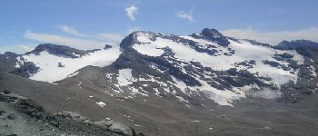
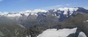
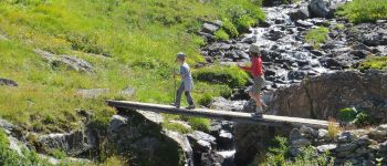
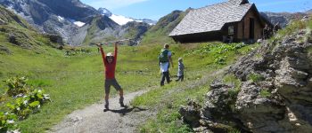
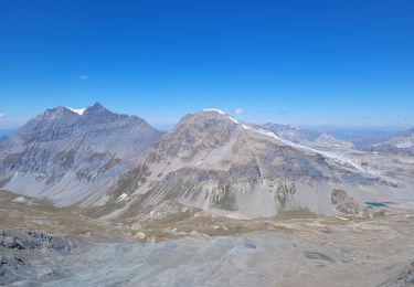
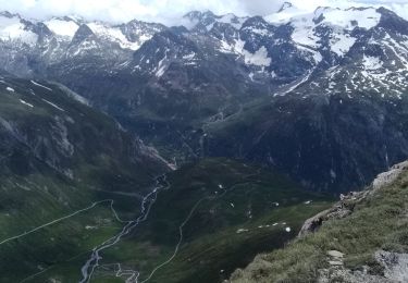
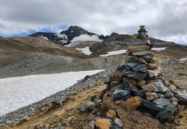
la montée jusqu'au refuge s’effectue sur un bon chemin, avec en fond le dôme de la sache, le mont pourri et la grande sassiere.
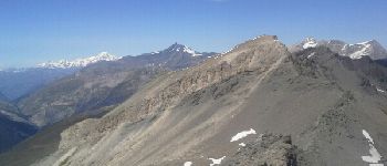
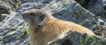
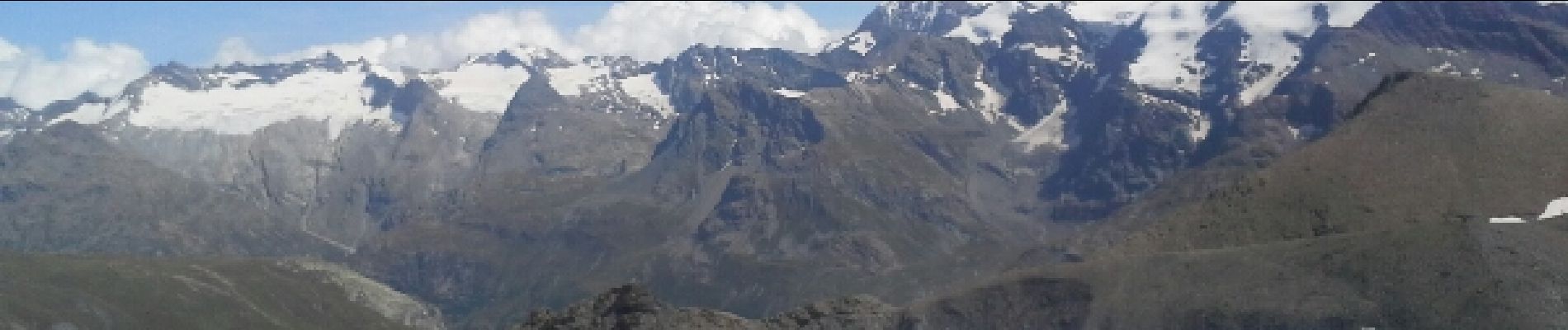
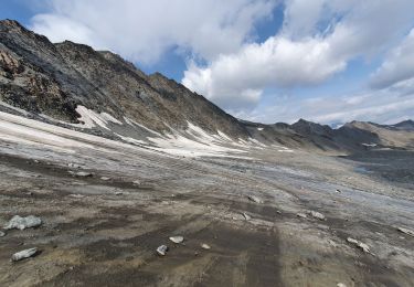
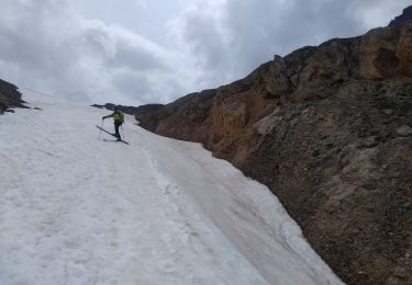
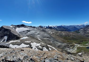
le col s'atteint facilement en suivant un sentier bien tracé. du col une sente assez facile vous guide jusqu'au sommet, ou vous attends un superbe panorama . en début de saison la présence de neige doit rendre beaucoup plus difficile l'itinéraire menant au sommet, alors prudence.
Localización
Comentarios
Excursiones cerca
![Excursión Senderismo Val-d'Isère - rocher du Charvet - Photo](https://media.geolcdn.com/t/375/260/695e5e9f-e8dc-4cf9-b576-ab38f18a42af.jpg&format=jpg&maxdim=2)
![Senderismo Senderismo](https://static1.geolcdn.com/sitytour/trail-icons/101.png)
Senderismo
![](/images/other/stat-length.png)
![](https://static1.geolcdn.com/siteimages/upload/files/16400158638029165_repeat_loop_refresh_sync_direction_icon.png)
![Excursión Senderismo Val-d'Isère - Les cascades des salins au départ de val d’Isère - Photo](https://media.geolcdn.com/t/375/260/c3b76218-f72c-4eeb-8155-41f32eab8f13.jpg&format=jpg&maxdim=2)
![Senderismo Senderismo](https://static1.geolcdn.com/sitytour/trail-icons/101.png)
Senderismo
![](/images/other/stat-length.png)
![](https://static1.geolcdn.com/siteimages/upload/files/16400158638029165_repeat_loop_refresh_sync_direction_icon.png)
![Excursión Senderismo Val-d'Isère - pointe de la Sana - Photo](https://media.geolcdn.com/t/375/260/cf1c2ddd-8e22-4533-8c04-6fcf89140ded.jpg&format=jpg&maxdim=2)
![Senderismo Senderismo](https://static1.geolcdn.com/sitytour/trail-icons/101.png)
Senderismo
![](/images/other/stat-length.png)
![](https://static1.geolcdn.com/siteimages/upload/files/16400158638029165_repeat_loop_refresh_sync_direction_icon.png)
![Excursión Senderismo Val-d'Isère - Lac, col et pointe de la Bailletaz - Photo](https://media.geolcdn.com/t/375/260/9d40bc9e-390f-4a5e-a6f3-053ea09f211b.jpg&format=jpg&maxdim=2)
![Senderismo Senderismo](https://static1.geolcdn.com/sitytour/trail-icons/101.png)
Senderismo
![](/images/other/stat-length.png)
![](https://static1.geolcdn.com/siteimages/upload/files/16400158638029165_repeat_loop_refresh_sync_direction_icon.png)
![Excursión Senderismo Val-d'Isère - pointe de la Sana - Photo](https://media.geolcdn.com/t/375/260/2a13a8e9-1e27-484a-a9e6-39b0a4ff9c6e.jpg&format=jpg&maxdim=2)
![Senderismo Senderismo](https://static1.geolcdn.com/sitytour/trail-icons/101.png)
Senderismo
![](/images/other/stat-length.png)
![](https://static1.geolcdn.com/siteimages/upload/files/16400158638029165_repeat_loop_refresh_sync_direction_icon.png)
![Excursión Esquí de fondo Bonneval-sur-Arc - col de Calabourdane, pointe nord de Bézin, col de Bézin - Photo](https://media.geolcdn.com/t/375/260/82b2df5e-dc5e-48f0-b4d4-d10398fafa9d.jpg&format=jpg&maxdim=2)
![Esquí de fondo Esquí de fondo](https://static1.geolcdn.com/sitytour/trail-icons/503.png)
Esquí de fondo
![](/images/other/stat-length.png)
![](https://static1.geolcdn.com/siteimages/upload/files/16400158638029165_repeat_loop_refresh_sync_direction_icon.png)
![Excursión Esquí de fondo Bonneval-sur-Arc - Tricotage au col de l'iseran - Photo](https://media.geolcdn.com/t/375/260/82300eb0-c716-486e-a37a-4e5efd5b3f81.jpg&format=jpg&maxdim=2)
![Esquí de fondo Esquí de fondo](https://static1.geolcdn.com/sitytour/trail-icons/503.png)
Esquí de fondo
![](/images/other/stat-length.png)
![](https://static1.geolcdn.com/siteimages/upload/files/16400158638029165_repeat_loop_refresh_sync_direction_icon.png)
![Excursión Senderismo Val-d'Isère - pointe de Méan Martin - Photo](https://media.geolcdn.com/t/375/260/e7b21b02-f5f9-4e0b-a59b-b8dbed1fe073.jpg&format=jpg&maxdim=2)
![Senderismo Senderismo](https://static1.geolcdn.com/sitytour/trail-icons/101.png)
Senderismo
![](/images/other/stat-length.png)
![](https://static1.geolcdn.com/siteimages/upload/files/16400158638029165_repeat_loop_refresh_sync_direction_icon.png)
![Excursión Senderismo Bonneval-sur-Arc - signal de l'Iseran - Photo](https://media.geolcdn.com/t/375/260/9c28b77f-4f31-4715-9b89-c8be4cd958bd.jpg&format=jpg&maxdim=2)
![Senderismo Senderismo](https://static1.geolcdn.com/sitytour/trail-icons/101.png)
Senderismo
![](/images/other/stat-length.png)
![](https://static1.geolcdn.com/siteimages/upload/files/16400158638029165_repeat_loop_refresh_sync_direction_icon.png)