![](/images/other/stat-length.png)
![Excursión Senderismo Maasmechelen - Mechelse Heide - Photo](https://media.geolcdn.com/t/1900/400/501f02e9-8086-4be8-98c9-f01120ddee06.jpg&format=pjpeg&maxdim=2)
Mechelse Heide
mumu.larandonneuse
Usuario GUIDE
![Longitud](/images/other/stat-length.png)
![Altitud máxima](https://static1.geolcdn.com/siteimages/upload/files/1508320355ic_sort_altitude_max_24dp.png)
![Desnivel positivo](https://static1.geolcdn.com/siteimages/upload/files/1508320355ic_sort_den_pos_24dp.png)
![Km-Effort](/images/other/stat-length.png)
![Altitud mínima](https://static1.geolcdn.com/siteimages/upload/files/1508320355ic_sort_altitude_min_24dp.png)
![Desnivel negativo](https://static1.geolcdn.com/siteimages/upload/files/1508320355ic_sort_den_neg_24dp.png)
![Boucle](https://static1.geolcdn.com/siteimages/upload/files/16400158638029165_repeat_loop_refresh_sync_direction_icon.png)
![Senderismo](https://static1.geolcdn.com/sitytour/trail-icons/101.png)
3h41
Dificultad : Fácil
![Escanee este código QR para abrir la excursión en la aplicación SityTrail](https://capi.geolives.com/qq0zvz2zws4bq2lad0pu/sitytour/trails/3375210/qr.png?size=200)
Aplicación GPS de excursión GRATIS
A propósito
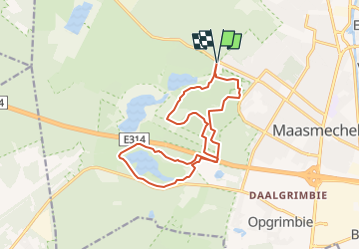
Ruta Senderismo de 14,2 km a descubrir en Flandes, Limburgo, Maasmechelen. Esta ruta ha sido propuesta por mumu.larandonneuse.
Descripción
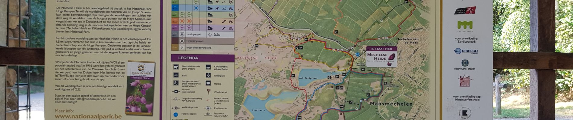
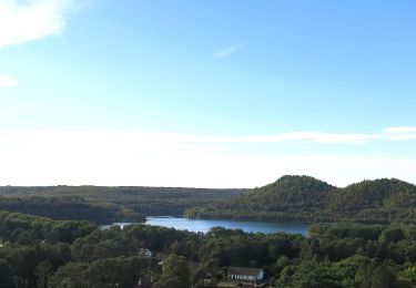
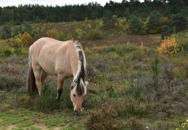
L'itinéraire traverse le Parc National de la Haute Campine (Hoge Kempen). Nous marchons dans le Mechelse Heide et dans la vallée du Kikbeekbron.
➕ La bruyère pourpre fleurit en août-septembre.
➕ De magnifiques vues.
📍& 🅿️ Porte d'entrée du parc : à Maasmechelen, Joseph Smeetslaan 280.
ℹ www.wandelgidszuidlimburg.com n°250 (modifié)
Localización
Comentarios
Excursiones cerca
![Excursión A pie As - Mechelse Heide Noord - Photo](https://media.geolcdn.com/t/375/260/6c3d6be9-86c4-472e-82c2-64c07d2c49aa.jpeg&format=jpg&maxdim=2)
![A pie A pie](https://static1.geolcdn.com/sitytour/trail-icons/100.png)
![Excursión A pie Maasmechelen - Erfgoedwandeling Eisden Tuinwijk - Photo](https://media.geolcdn.com/t/375/260/28db0122-7bbc-4a11-ae3a-faea898e04f5.jpeg&format=jpg&maxdim=2)
![A pie A pie](https://static1.geolcdn.com/sitytour/trail-icons/100.png)
A pie
![](/images/other/stat-length.png)
![](https://static1.geolcdn.com/siteimages/upload/files/16400158638029165_repeat_loop_refresh_sync_direction_icon.png)
![Excursión A pie Dilsen-Stokkem - Connecterra Rode driehoek - Photo](https://media.geolcdn.com/t/375/260/5eb5c103-eb27-4a59-83d3-dfd2672ebb0c.jpeg&format=jpg&maxdim=2)
![A pie A pie](https://static1.geolcdn.com/sitytour/trail-icons/100.png)
A pie
![](/images/other/stat-length.png)
![](https://static1.geolcdn.com/siteimages/upload/files/16400158638029165_repeat_loop_refresh_sync_direction_icon.png)
![Excursión A pie Maasmechelen - Station As Groene rechthoek - Photo](https://media.geolcdn.com/t/375/260/6c3d6be9-86c4-472e-82c2-64c07d2c49aa.jpeg&format=jpg&maxdim=2)
![A pie A pie](https://static1.geolcdn.com/sitytour/trail-icons/100.png)
A pie
![](/images/other/stat-length.png)
![](https://static1.geolcdn.com/siteimages/upload/files/16400158638029165_repeat_loop_refresh_sync_direction_icon.png)
![Excursión A pie Maasmechelen - Leut & Meeswijk Gele zeshoek - Photo](https://media.geolcdn.com/t/375/260/3a349166-7856-4cc9-a007-a2d01b733e80.jpeg&format=jpg&maxdim=2)
![A pie A pie](https://static1.geolcdn.com/sitytour/trail-icons/100.png)
A pie
![](/images/other/stat-length.png)
![](https://static1.geolcdn.com/siteimages/upload/files/16400158638029165_repeat_loop_refresh_sync_direction_icon.png)
![Excursión A pie Maasmechelen - Station As Blauwe ruit - Photo](https://media.geolcdn.com/t/375/260/6c3d6be9-86c4-472e-82c2-64c07d2c49aa.jpeg&format=jpg&maxdim=2)
![A pie A pie](https://static1.geolcdn.com/sitytour/trail-icons/100.png)
A pie
![](/images/other/stat-length.png)
![](https://static1.geolcdn.com/siteimages/upload/files/16400158638029165_repeat_loop_refresh_sync_direction_icon.png)
![Excursión A pie Maasmechelen - Station As Rode driehoek - Photo](https://media.geolcdn.com/t/375/260/6649a029-f07f-4f45-b4d8-2b574463e7fd.jpeg&format=jpg&maxdim=2)
![A pie A pie](https://static1.geolcdn.com/sitytour/trail-icons/100.png)
A pie
![](/images/other/stat-length.png)
![](https://static1.geolcdn.com/siteimages/upload/files/16400158638029165_repeat_loop_refresh_sync_direction_icon.png)
![Excursión A pie Dilsen-Stokkem - Litzberg groene rechthoek - Photo](https://media.geolcdn.com/t/375/260/085d16b1-ffd1-4281-a4d3-38ce31d4ff24.jpeg&format=jpg&maxdim=2)
![A pie A pie](https://static1.geolcdn.com/sitytour/trail-icons/100.png)
A pie
![](/images/other/stat-length.png)
![](https://static1.geolcdn.com/siteimages/upload/files/16400158638029165_repeat_loop_refresh_sync_direction_icon.png)
![Excursión A pie Maasmechelen - Kikbeekbron Blauwe ruit - Photo](https://media.geolcdn.com/t/375/260/521012e3-78f7-4de8-bd02-5fa632ecd33f.jpeg&format=jpg&maxdim=2)
![A pie A pie](https://static1.geolcdn.com/sitytour/trail-icons/100.png)
A pie
![](/images/other/stat-length.png)
![](https://static1.geolcdn.com/siteimages/upload/files/16400158638029165_repeat_loop_refresh_sync_direction_icon.png)
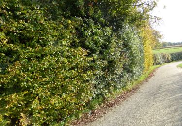
Superbe parcours 100 % nature.