![](/images/other/stat-length.png)
![Excursión Senderismo Val-Cenis - trace_GPX_tour_Ambin_4j - Photo](https://media.geolcdn.com/t/1900/400/ext.pjpeg?maxdim=2&url=https%3A%2F%2Fstatic1.geolcdn.com%2Fsiteimages%2Fupload%2Ffiles%2F1553511878bg_sport_marche.png)
trace_GPX_tour_Ambin_4j
aris
Usuario
![Longitud](/images/other/stat-length.png)
![Altitud máxima](https://static1.geolcdn.com/siteimages/upload/files/1508320355ic_sort_altitude_max_24dp.png)
![Desnivel positivo](https://static1.geolcdn.com/siteimages/upload/files/1508320355ic_sort_den_pos_24dp.png)
![Km-Effort](/images/other/stat-length.png)
![Altitud mínima](https://static1.geolcdn.com/siteimages/upload/files/1508320355ic_sort_altitude_min_24dp.png)
![Desnivel negativo](https://static1.geolcdn.com/siteimages/upload/files/1508320355ic_sort_den_neg_24dp.png)
![Boucle](https://static1.geolcdn.com/siteimages/upload/files/16400158638029165_repeat_loop_refresh_sync_direction_icon.png)
![Senderismo](https://static1.geolcdn.com/sitytour/trail-icons/101.png)
19h08
Dificultad : Difícil
![Escanee este código QR para abrir la excursión en la aplicación SityTrail](https://capi.geolives.com/qq0zvz2zws4bq2lad0pu/sitytour/trails/3364063/qr.png?size=200)
Aplicación GPS de excursión GRATIS
A propósito
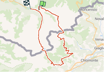
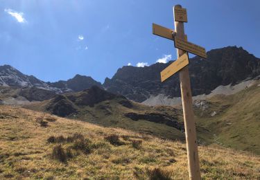
Ruta Senderismo de 46 km a descubrir en Auvergne-Rhône-Alpes, Saboya, Val-Cenis. Esta ruta ha sido propuesta por aris.
Descripción
Inspiré de ce site https://www.altituderando.com/Tour-d-Ambin-en-4-jours-par-les-refuges-d-Ambin-Levi-Molinari-Vaccarone-et-du
Parcours dans le sens horaire (peut-être plus facile pour la montée au col d'Ambin côté italien).
Il manque les premiers 200m entre le refuge du Suffet et le début de la trace.
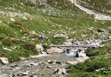
Pour la 1ère étape Suffet->Vaccarone, j'ai rajouté un détour par les lacs Giaset. Vraiment jolis, mais ça fait un dénivellé positif de 1400m...
Le refuge Levi-Molinari est vraiment top. Et au refuge du Suffet, on mange très bien :)
Localización
Comentarios
Excursiones cerca
![Excursión Senderismo Val-Cenis - signal du Petit Mont-Cenis Cenis - Photo](https://media.geolcdn.com/t/375/260/ext.jpg?maxdim=2&url=https%3A%2F%2Fservices.sitytrail.com%2FGeolivesWS%2FDownloadMedia.ashx%3FTrailID%3D615956%26Media%3Dfix__20160817102723.jpg)
![Senderismo Senderismo](https://static1.geolcdn.com/sitytour/trail-icons/101.png)
Senderismo
![](/images/other/stat-length.png)
![](https://static1.geolcdn.com/siteimages/upload/files/16400158638029165_repeat_loop_refresh_sync_direction_icon.png)
![Excursión Senderismo Val-Cenis - Lac de Savinne - Photo](https://media.geolcdn.com/t/375/260/ext.jpg?maxdim=2&url=https%3A%2F%2Fstatic1.geolcdn.com%2Fsiteimages%2Fupload%2Ffiles%2F1553511878bg_sport_marche.png)
![Senderismo Senderismo](https://static1.geolcdn.com/sitytour/trail-icons/101.png)
Senderismo
![](/images/other/stat-length.png)
![](https://static1.geolcdn.com/siteimages/upload/files/16400158638029165_repeat_loop_refresh_sync_direction_icon.png)
![Excursión Senderismo Val-Cenis - Savoie_Bramans-LePlanay=>Alpages_de_Montbas - Photo](https://media.geolcdn.com/t/375/260/e2fc6e3f-d7d3-4a11-84a0-df6a02af42c8.jpg&format=jpg&maxdim=2)
![Senderismo Senderismo](https://static1.geolcdn.com/sitytour/trail-icons/101.png)
Senderismo
![](/images/other/stat-length.png)
![](https://static1.geolcdn.com/siteimages/upload/files/16400158638029165_repeat_loop_refresh_sync_direction_icon.png)
![Excursión Senderismo Val-Cenis - Refuge du petit Mont-Cenis - Col de Bellecombe - Photo](https://media.geolcdn.com/t/375/260/6ef1a6b7-2407-4d68-aa00-60607ba7429d.jpg&format=jpg&maxdim=2)
![Senderismo Senderismo](https://static1.geolcdn.com/sitytour/trail-icons/101.png)
Senderismo
![](/images/other/stat-length.png)
![](https://static1.geolcdn.com/siteimages/upload/files/16400158638029165_repeat_loop_refresh_sync_direction_icon.png)
![Excursión Senderismo Val-Cenis - Col agnel puis Lac d'Ambin Bramans - Photo](https://media.geolcdn.com/t/375/260/1745d82d-7eda-48ff-b6de-c3bab13e3684.jpg&format=jpg&maxdim=2)
![Senderismo Senderismo](https://static1.geolcdn.com/sitytour/trail-icons/101.png)
Senderismo
![](/images/other/stat-length.png)
![](https://static1.geolcdn.com/siteimages/upload/files/16400158638029165_repeat_loop_refresh_sync_direction_icon.png)
![Excursión Senderismo Val-Cenis - Col d'Etache - gros Peyron - Bec d'Etache - Photo](https://media.geolcdn.com/t/375/260/5aeb25f3-8e0d-4d55-9235-334883bccd5e.jpg&format=jpg&maxdim=2)
![Senderismo Senderismo](https://static1.geolcdn.com/sitytour/trail-icons/101.png)
Senderismo
![](/images/other/stat-length.png)
![](https://static1.geolcdn.com/siteimages/upload/files/16400158638029165_repeat_loop_refresh_sync_direction_icon.png)
![Excursión Senderismo Val-Cenis - Parking Etache - Pas de la Coche Bramans - Photo](https://media.geolcdn.com/t/375/260/0946d2b3-7a1a-44f3-90e2-4cbe032d6378.jpg&format=jpg&maxdim=2)
![Senderismo Senderismo](https://static1.geolcdn.com/sitytour/trail-icons/101.png)
Senderismo
![](/images/other/stat-length.png)
![](https://static1.geolcdn.com/siteimages/upload/files/16400158638029165_repeat_loop_refresh_sync_direction_icon.png)
![Excursión Senderismo Val-Cenis - Val Cenis - boucle par les crêtes de Montiolit - Photo](https://media.geolcdn.com/t/375/260/373b5ffc-ed0a-4aeb-b6a6-6c753469bddc.jpg&format=jpg&maxdim=2)
![Senderismo Senderismo](https://static1.geolcdn.com/sitytour/trail-icons/101.png)
Senderismo
![](/images/other/stat-length.png)
![](https://static1.geolcdn.com/siteimages/upload/files/16400158638029165_repeat_loop_refresh_sync_direction_icon.png)
![Excursión Senderismo Val-Cenis - BRAMANS - 73 - Photo](https://media.geolcdn.com/t/375/260/c671f643-1828-4d5b-84a6-28d52fabe947.jpg&format=jpg&maxdim=2)
![Senderismo Senderismo](https://static1.geolcdn.com/sitytour/trail-icons/101.png)
Senderismo
![](/images/other/stat-length.png)
![](https://static1.geolcdn.com/siteimages/upload/files/16400158638029165_repeat_loop_refresh_sync_direction_icon.png)