![](/images/other/stat-length.png)
![Excursión Senderismo Raeren - 2022-08-19_14h00m57_raeren-roetgen - Photo](https://media.geolcdn.com/t/1900/400/ext.pjpeg?maxdim=2&url=https%3A%2F%2Fstatic1.geolcdn.com%2Fsiteimages%2Fupload%2Ffiles%2F1553511878bg_sport_marche.png)
2022-08-19_14h00m57_raeren-roetgen
mumu.larandonneuse
Usuario GUIDE
![Longitud](/images/other/stat-length.png)
![Altitud máxima](https://static1.geolcdn.com/siteimages/upload/files/1508320355ic_sort_altitude_max_24dp.png)
![Desnivel positivo](https://static1.geolcdn.com/siteimages/upload/files/1508320355ic_sort_den_pos_24dp.png)
![Km-Effort](/images/other/stat-length.png)
![Altitud mínima](https://static1.geolcdn.com/siteimages/upload/files/1508320355ic_sort_altitude_min_24dp.png)
![Desnivel negativo](https://static1.geolcdn.com/siteimages/upload/files/1508320355ic_sort_den_neg_24dp.png)
![Boucle](https://static1.geolcdn.com/siteimages/upload/files/16400158638029165_repeat_loop_refresh_sync_direction_icon.png)
![Senderismo](https://static1.geolcdn.com/sitytour/trail-icons/101.png)
3h42
Dificultad : Medio
![Escanee este código QR para abrir la excursión en la aplicación SityTrail](https://capi.geolives.com/qq0zvz2zws4bq2lad0pu/sitytour/trails/3359990/qr.png?size=200)
Aplicación GPS de excursión GRATIS
A propósito
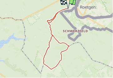
Ruta Senderismo de 13,9 km a descubrir en Valonia, Lieja, Raeren. Esta ruta ha sido propuesta por mumu.larandonneuse.
Descripción
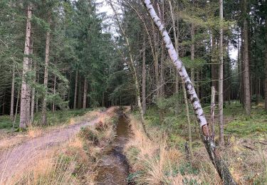
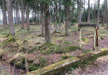
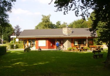
Le Reinartzhof, le Fagne de Kutenhart, l'Eschbach et la vallée de la Vesdre sont les points forts du parcours, bienvenue en terre sauvage !
Suivez les points-nœuds : 32 > 95 > 38 > 21 > 87 > 98 > 92 > 37 > 90 > 93 > 87 > 21 > 95 > 32
ℹ www.ostbelgien.eu ➡️ Balade n° 21
⚠️ 🐕 interdit
Localización
Comentarios
Excursiones cerca
![Excursión Senderismo Raeren - 2021-08-07_23h28m55_raeren - Photo](https://media.geolcdn.com/t/375/260/423c8447-b257-4538-8bf5-b82f7fde1439.jpg&format=jpg&maxdim=2)
![Senderismo Senderismo](https://static1.geolcdn.com/sitytour/trail-icons/101.png)
Senderismo
![](/images/other/stat-length.png)
![](https://static1.geolcdn.com/siteimages/upload/files/16400158638029165_repeat_loop_refresh_sync_direction_icon.png)
![Excursión Senderismo Raeren - Petergensfeld - Natura 2000, des sites qui valent le détour - Lg21 - Photo](https://media.geolcdn.com/t/375/260/ext.jpg?maxdim=2&url=https%3A%2F%2Fservices.sitytrail.com%2FGeolivesWS%2FDownloadMedia.ashx%3FTrailID%3D612568%26Media%3D681f47ef-4b07-41b4-ba43-227c6775122c.JPG)
![Senderismo Senderismo](https://static1.geolcdn.com/sitytour/trail-icons/101.png)
Senderismo
![](/images/other/stat-length.png)
![](https://static1.geolcdn.com/siteimages/upload/files/16400158638029165_repeat_loop_refresh_sync_direction_icon.png)
![Excursión Senderismo Raeren - Raeren Roetgen Eifelsteig 23 km - Photo](https://media.geolcdn.com/t/375/260/b745ae07-9105-45c9-80e8-b03ad5d85aa5.jpg&format=jpg&maxdim=2)
![Senderismo Senderismo](https://static1.geolcdn.com/sitytour/trail-icons/101.png)
Senderismo
![](/images/other/stat-length.png)
![](https://static1.geolcdn.com/siteimages/upload/files/16400158638029165_repeat_loop_refresh_sync_direction_icon.png)
![Excursión A pie Roetgen - Hahner Straße Rundweg A2 - Photo](https://media.geolcdn.com/t/375/260/e319a090-49eb-475c-8cdf-c884ac2bc115.jpeg&format=jpg&maxdim=2)
![A pie A pie](https://static1.geolcdn.com/sitytour/trail-icons/100.png)
A pie
![](/images/other/stat-length.png)
![](https://static1.geolcdn.com/siteimages/upload/files/16400158638029165_repeat_loop_refresh_sync_direction_icon.png)
![Excursión A pie Roetgen - Kall-Rur-Panorama-Route - Photo](https://media.geolcdn.com/t/375/260/79cfdf58-b035-4b32-b417-7c994ebf268e.jpeg&format=jpg&maxdim=2)
![A pie A pie](https://static1.geolcdn.com/sitytour/trail-icons/100.png)
A pie
![](/images/other/stat-length.png)
![](https://static1.geolcdn.com/siteimages/upload/files/16400158638029165_repeat_loop_refresh_sync_direction_icon.png)
![Excursión A pie Roetgen - Rott Rundweg A3 - Photo](https://media.geolcdn.com/t/375/260/68d54c01-37fc-4225-b77f-3c3692b6e11c.jpeg&format=jpg&maxdim=2)
![A pie A pie](https://static1.geolcdn.com/sitytour/trail-icons/100.png)
A pie
![](/images/other/stat-length.png)
![](https://static1.geolcdn.com/siteimages/upload/files/16400158638029165_repeat_loop_refresh_sync_direction_icon.png)
![Excursión A pie Roetgen - Struffelt-Route (Eifel) - Photo](https://media.geolcdn.com/t/375/260/e319a090-49eb-475c-8cdf-c884ac2bc115.jpeg&format=jpg&maxdim=2)
![A pie A pie](https://static1.geolcdn.com/sitytour/trail-icons/100.png)
A pie
![](/images/other/stat-length.png)
![](https://static1.geolcdn.com/siteimages/upload/files/16400158638029165_repeat_loop_refresh_sync_direction_icon.png)
![Excursión A pie Raeren - Raerener Wald - Photo](https://media.geolcdn.com/t/375/260/6b60186b-6371-474b-8728-a21215d838fc.jpeg&format=jpg&maxdim=2)
![A pie A pie](https://static1.geolcdn.com/sitytour/trail-icons/100.png)
![Excursión A pie Roetgen - Dorfrundgang Roetgen - Photo](https://media.geolcdn.com/t/375/260/6f9b91f1-4d12-490b-8774-c1691acc9755.jpeg&format=jpg&maxdim=2)
![A pie A pie](https://static1.geolcdn.com/sitytour/trail-icons/100.png)
A pie
![](/images/other/stat-length.png)
![](https://static1.geolcdn.com/siteimages/upload/files/16400158638029165_repeat_loop_refresh_sync_direction_icon.png)
Magnifique, 100% nature. 💚 Coup de cœur. ‼️Au points-noeud 87, juste après le pont, après 20 m., il manque le balisage de rappel vers 98 pour tourner à droite et emprunter le petit sentier le long du ruisseau.