![](/images/other/stat-length.png)
![Excursión Senderismo Maasmechelen - Terhills à Maasmechelen - Long et petit terril - Photo](https://media.geolcdn.com/t/1900/400/bef8f3f3-7801-4803-b493-9ed2bbdcdcf1.jpeg&format=pjpeg&maxdim=2)
Terhills à Maasmechelen - Long et petit terril
Benjamin27
Usuario GUIDE
![Longitud](/images/other/stat-length.png)
![Altitud máxima](https://static1.geolcdn.com/siteimages/upload/files/1508320355ic_sort_altitude_max_24dp.png)
![Desnivel positivo](https://static1.geolcdn.com/siteimages/upload/files/1508320355ic_sort_den_pos_24dp.png)
![Km-Effort](/images/other/stat-length.png)
![Altitud mínima](https://static1.geolcdn.com/siteimages/upload/files/1508320355ic_sort_altitude_min_24dp.png)
![Desnivel negativo](https://static1.geolcdn.com/siteimages/upload/files/1508320355ic_sort_den_neg_24dp.png)
![Boucle](https://static1.geolcdn.com/siteimages/upload/files/16400158638029165_repeat_loop_refresh_sync_direction_icon.png)
![Senderismo](https://static1.geolcdn.com/sitytour/trail-icons/101.png)
1h27
Dificultad : Medio
![Escanee este código QR para abrir la excursión en la aplicación SityTrail](https://capi.geolives.com/qq0zvz2zws4bq2lad0pu/sitytour/trails/3350271/qr.png?size=200)
Aplicación GPS de excursión GRATIS
A propósito
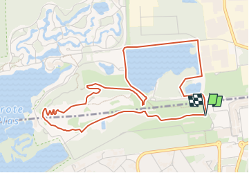
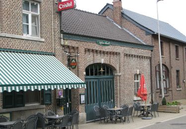
Ruta Senderismo de 5,3 km a descubrir en Flandes, Limburgo, Maasmechelen. Esta ruta ha sido propuesta por Benjamin27.
Descripción
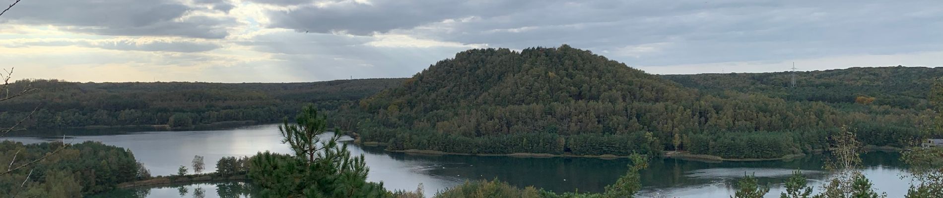
Ancien site d’exploitation minière qui vous emmènera en haut des collines artificielles créées par les miniers. A ne pas manquer!
👣 Distance : 5,4km - balisage losange bleu.
📍Départ : au rond-point de croisement entre Zetellaan et Kolenmijn Limburg-Maaslaan à Maasmechelen, prendre à droite et se garer dans le parking prévu à gauche. Marcher ensuite jusqu’au départ des promenades en s’aidant des indications sur place.
🚂🚍 Aller à la gare de Hasselt et prendre le bus DE LIJN 45 jusqu’à l’arrêt « Eisden - Maasmechelen Village ».
Localización
Comentarios
Excursiones cerca
![Excursión Senderismo Maasmechelen - Mechelse Heide - Photo](https://media.geolcdn.com/t/375/260/501f02e9-8086-4be8-98c9-f01120ddee06.jpg&format=jpg&maxdim=2)
![Senderismo Senderismo](https://static1.geolcdn.com/sitytour/trail-icons/101.png)
Senderismo
![](/images/other/stat-length.png)
![](https://static1.geolcdn.com/siteimages/upload/files/16400158638029165_repeat_loop_refresh_sync_direction_icon.png)
![Excursión A pie Maasmechelen - Erfgoedwandeling Eisden Tuinwijk - Photo](https://media.geolcdn.com/t/375/260/28db0122-7bbc-4a11-ae3a-faea898e04f5.jpeg&format=jpg&maxdim=2)
![A pie A pie](https://static1.geolcdn.com/sitytour/trail-icons/100.png)
A pie
![](/images/other/stat-length.png)
![](https://static1.geolcdn.com/siteimages/upload/files/16400158638029165_repeat_loop_refresh_sync_direction_icon.png)
![Excursión A pie Dilsen-Stokkem - Connecterra Rode driehoek - Photo](https://media.geolcdn.com/t/375/260/5eb5c103-eb27-4a59-83d3-dfd2672ebb0c.jpeg&format=jpg&maxdim=2)
![A pie A pie](https://static1.geolcdn.com/sitytour/trail-icons/100.png)
A pie
![](/images/other/stat-length.png)
![](https://static1.geolcdn.com/siteimages/upload/files/16400158638029165_repeat_loop_refresh_sync_direction_icon.png)
![Excursión A pie Dilsen-Stokkem - Stokkem & Oud-Dilsen Blauwe ruit - Photo](https://media.geolcdn.com/t/375/260/da26fab3-9e40-4ac6-a054-30a79ea1636f.jpeg&format=jpg&maxdim=2)
![A pie A pie](https://static1.geolcdn.com/sitytour/trail-icons/100.png)
A pie
![](/images/other/stat-length.png)
![](https://static1.geolcdn.com/siteimages/upload/files/16400158638029165_repeat_loop_refresh_sync_direction_icon.png)
![Excursión A pie Maaseik - Bergerven Blauwe ruit - Photo](https://media.geolcdn.com/t/375/260/050a923b-2af9-40e2-aacc-99779fc4e3d7.jpeg&format=jpg&maxdim=2)
![A pie A pie](https://static1.geolcdn.com/sitytour/trail-icons/100.png)
A pie
![](/images/other/stat-length.png)
![](https://static1.geolcdn.com/siteimages/upload/files/16400158638029165_repeat_loop_refresh_sync_direction_icon.png)
![Excursión A pie Maasmechelen - Leut & Meeswijk Oranje bol - Photo](https://media.geolcdn.com/t/375/260/7b6d2e92-3c0b-4eee-8e68-d0c378b09212.jpeg&format=jpg&maxdim=2)
![A pie A pie](https://static1.geolcdn.com/sitytour/trail-icons/100.png)
A pie
![](/images/other/stat-length.png)
![](https://static1.geolcdn.com/siteimages/upload/files/16400158638029165_repeat_loop_refresh_sync_direction_icon.png)
![Excursión A pie Maasmechelen - Leut & Meeswijk Rode driehoek - Photo](https://media.geolcdn.com/t/375/260/7b6d2e92-3c0b-4eee-8e68-d0c378b09212.jpeg&format=jpg&maxdim=2)
![A pie A pie](https://static1.geolcdn.com/sitytour/trail-icons/100.png)
A pie
![](/images/other/stat-length.png)
![](https://static1.geolcdn.com/siteimages/upload/files/16400158638029165_repeat_loop_refresh_sync_direction_icon.png)
![Excursión A pie Maasmechelen - Leut & Meeswijk Gele zeshoek - Photo](https://media.geolcdn.com/t/375/260/3a349166-7856-4cc9-a007-a2d01b733e80.jpeg&format=jpg&maxdim=2)
![A pie A pie](https://static1.geolcdn.com/sitytour/trail-icons/100.png)
A pie
![](/images/other/stat-length.png)
![](https://static1.geolcdn.com/siteimages/upload/files/16400158638029165_repeat_loop_refresh_sync_direction_icon.png)
![Excursión A pie Maasmechelen - Leut & Meeswijk Groene rechthoek - Photo](https://media.geolcdn.com/t/375/260/7b6d2e92-3c0b-4eee-8e68-d0c378b09212.jpeg&format=jpg&maxdim=2)
![A pie A pie](https://static1.geolcdn.com/sitytour/trail-icons/100.png)
A pie
![](/images/other/stat-length.png)
![](https://static1.geolcdn.com/siteimages/upload/files/16400158638029165_repeat_loop_refresh_sync_direction_icon.png)