![](/images/other/stat-length.png)
![Excursión Senderismo Maasmechelen - Mechelse Heide à Maasmechelen - Les bruyères - Photo](https://media.geolcdn.com/t/1900/400/e08fe853-34e2-4b60-bdd4-b436aae5fcc1.jpeg&format=pjpeg&maxdim=2)
Mechelse Heide à Maasmechelen - Les bruyères
Benjamin27
Usuario GUIDE
![Longitud](/images/other/stat-length.png)
![Altitud máxima](https://static1.geolcdn.com/siteimages/upload/files/1508320355ic_sort_altitude_max_24dp.png)
![Desnivel positivo](https://static1.geolcdn.com/siteimages/upload/files/1508320355ic_sort_den_pos_24dp.png)
![Km-Effort](/images/other/stat-length.png)
![Altitud mínima](https://static1.geolcdn.com/siteimages/upload/files/1508320355ic_sort_altitude_min_24dp.png)
![Desnivel negativo](https://static1.geolcdn.com/siteimages/upload/files/1508320355ic_sort_den_neg_24dp.png)
![Boucle](https://static1.geolcdn.com/siteimages/upload/files/16400158638029165_repeat_loop_refresh_sync_direction_icon.png)
![Senderismo](https://static1.geolcdn.com/sitytour/trail-icons/101.png)
1h27
Dificultad : Medio
![Escanee este código QR para abrir la excursión en la aplicación SityTrail](https://capi.geolives.com/qq0zvz2zws4bq2lad0pu/sitytour/trails/3350270/qr.png?size=200)
Aplicación GPS de excursión GRATIS
A propósito
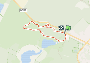
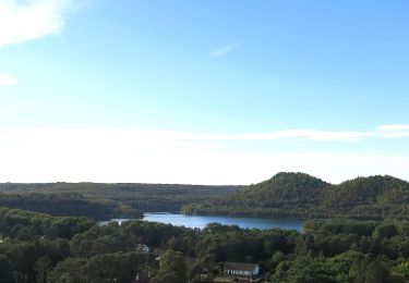
Ruta Senderismo de 5,5 km a descubrir en Flandes, Limburgo, Maasmechelen. Esta ruta ha sido propuesta por Benjamin27.
Descripción
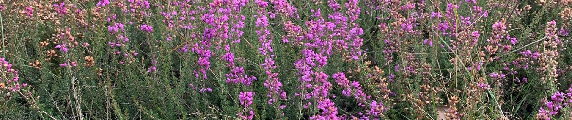
Champs infinis de bruyères dans un paysage désertique et typique de la Haute Campine.
👣 Distance : 5,6km - balisage hexagone jaune.
📍Départ : Toegangspoort Mechelse Heide, Joseph Smeetslaan 280 - 3630 Maasmechelen.
🚂🚍 Aller à la gare de Genk et prendre le bus DE LIJN 9 jusqu’à l’arrêt « Maasmechelen - Mechelse Heide ».
Localización
Comentarios
Excursiones cerca
![Excursión Senderismo Maasmechelen - Mechelse Heide - Photo](https://media.geolcdn.com/t/375/260/501f02e9-8086-4be8-98c9-f01120ddee06.jpg&format=jpg&maxdim=2)
![Senderismo Senderismo](https://static1.geolcdn.com/sitytour/trail-icons/101.png)
Senderismo
![](/images/other/stat-length.png)
![](https://static1.geolcdn.com/siteimages/upload/files/16400158638029165_repeat_loop_refresh_sync_direction_icon.png)
![Excursión A pie As - Mechelse Heide Noord - Photo](https://media.geolcdn.com/t/375/260/6c3d6be9-86c4-472e-82c2-64c07d2c49aa.jpeg&format=jpg&maxdim=2)
![A pie A pie](https://static1.geolcdn.com/sitytour/trail-icons/100.png)
![Excursión A pie Maasmechelen - Erfgoedwandeling Eisden Tuinwijk - Photo](https://media.geolcdn.com/t/375/260/28db0122-7bbc-4a11-ae3a-faea898e04f5.jpeg&format=jpg&maxdim=2)
![A pie A pie](https://static1.geolcdn.com/sitytour/trail-icons/100.png)
A pie
![](/images/other/stat-length.png)
![](https://static1.geolcdn.com/siteimages/upload/files/16400158638029165_repeat_loop_refresh_sync_direction_icon.png)
![Excursión A pie Dilsen-Stokkem - Connecterra Rode driehoek - Photo](https://media.geolcdn.com/t/375/260/5eb5c103-eb27-4a59-83d3-dfd2672ebb0c.jpeg&format=jpg&maxdim=2)
![A pie A pie](https://static1.geolcdn.com/sitytour/trail-icons/100.png)
A pie
![](/images/other/stat-length.png)
![](https://static1.geolcdn.com/siteimages/upload/files/16400158638029165_repeat_loop_refresh_sync_direction_icon.png)
![Excursión A pie Maasmechelen - Station As Groene rechthoek - Photo](https://media.geolcdn.com/t/375/260/6c3d6be9-86c4-472e-82c2-64c07d2c49aa.jpeg&format=jpg&maxdim=2)
![A pie A pie](https://static1.geolcdn.com/sitytour/trail-icons/100.png)
A pie
![](/images/other/stat-length.png)
![](https://static1.geolcdn.com/siteimages/upload/files/16400158638029165_repeat_loop_refresh_sync_direction_icon.png)
![Excursión A pie Maasmechelen - Leut & Meeswijk Gele zeshoek - Photo](https://media.geolcdn.com/t/375/260/3a349166-7856-4cc9-a007-a2d01b733e80.jpeg&format=jpg&maxdim=2)
![A pie A pie](https://static1.geolcdn.com/sitytour/trail-icons/100.png)
A pie
![](/images/other/stat-length.png)
![](https://static1.geolcdn.com/siteimages/upload/files/16400158638029165_repeat_loop_refresh_sync_direction_icon.png)
![Excursión A pie Maasmechelen - Station As Blauwe ruit - Photo](https://media.geolcdn.com/t/375/260/6c3d6be9-86c4-472e-82c2-64c07d2c49aa.jpeg&format=jpg&maxdim=2)
![A pie A pie](https://static1.geolcdn.com/sitytour/trail-icons/100.png)
A pie
![](/images/other/stat-length.png)
![](https://static1.geolcdn.com/siteimages/upload/files/16400158638029165_repeat_loop_refresh_sync_direction_icon.png)
![Excursión A pie Maasmechelen - Station As Rode driehoek - Photo](https://media.geolcdn.com/t/375/260/6649a029-f07f-4f45-b4d8-2b574463e7fd.jpeg&format=jpg&maxdim=2)
![A pie A pie](https://static1.geolcdn.com/sitytour/trail-icons/100.png)
A pie
![](/images/other/stat-length.png)
![](https://static1.geolcdn.com/siteimages/upload/files/16400158638029165_repeat_loop_refresh_sync_direction_icon.png)
![Excursión A pie Dilsen-Stokkem - Litzberg groene rechthoek - Photo](https://media.geolcdn.com/t/375/260/085d16b1-ffd1-4281-a4d3-38ce31d4ff24.jpeg&format=jpg&maxdim=2)
![A pie A pie](https://static1.geolcdn.com/sitytour/trail-icons/100.png)
A pie
![](/images/other/stat-length.png)
![](https://static1.geolcdn.com/siteimages/upload/files/16400158638029165_repeat_loop_refresh_sync_direction_icon.png)