![](/images/other/stat-length.png)
![Excursión Senderismo Portbou - Sentier du Littoral : Cerbère à Port-Vendres - Photo](https://media.geolcdn.com/t/1900/400/ext.pjpeg?maxdim=2&url=https%3A%2F%2Fmedia.geolcdn.com%2Ff%2Fa5cd91fe-c1c7-440b-b389-381c70fd5be6.jpg)
Sentier du Littoral : Cerbère à Port-Vendres
toutankhcarton
Usuario
![Longitud](/images/other/stat-length.png)
Longitud
24 km
![Altitud máxima](https://static1.geolcdn.com/siteimages/upload/files/1508320355ic_sort_altitude_max_24dp.png)
Altitud máxima
146 m
![Desnivel positivo](https://static1.geolcdn.com/siteimages/upload/files/1508320355ic_sort_den_pos_24dp.png)
Desnivel positivo
644 m
![Km-Effort](/images/other/stat-length.png)
Km-Effort
33 km
![Altitud mínima](https://static1.geolcdn.com/siteimages/upload/files/1508320355ic_sort_altitude_min_24dp.png)
Altitud mínima
-2 m
![Desnivel negativo](https://static1.geolcdn.com/siteimages/upload/files/1508320355ic_sort_den_neg_24dp.png)
Desnivel negativo
760 m
![Boucle](https://static1.geolcdn.com/siteimages/upload/files/16400158638029165_repeat_loop_refresh_sync_direction_icon.png)
Boucle
No
Fecha de creación :
2022-08-10 04:46:32.91
Última modificación :
2022-08-11 08:00:07.276
![Senderismo](https://static1.geolcdn.com/sitytour/trail-icons/101.png)
6h24
Dificultad : Difícil
![Escanee este código QR para abrir la excursión en la aplicación SityTrail](https://capi.geolives.com/qq0zvz2zws4bq2lad0pu/sitytour/trails/3349615/qr.png?size=200)
Aplicación GPS de excursión GRATIS
A propósito
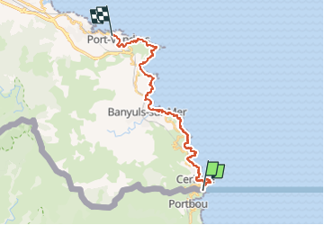
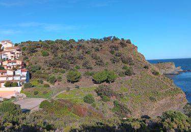
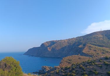
Ruta Senderismo de 24 km a descubrir en Cataluña, Gerona, Portbou. Esta ruta ha sido propuesta por toutankhcarton.
Descripción
Départ de la casemate du col des Belitres.
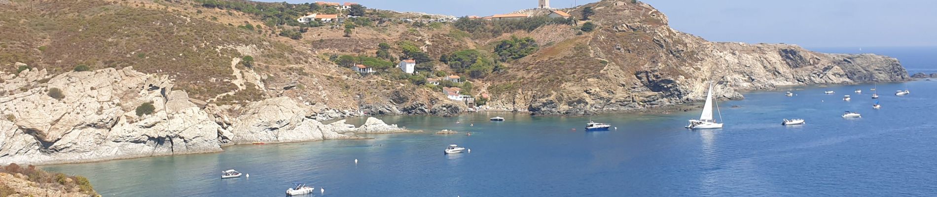
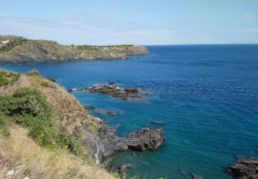
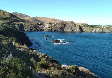
Passage par Cerbère, Banyuls, Port-Vendres
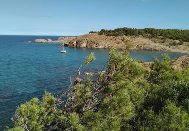
Cap Cerbère - Cap Canadell - Cap de Peyrefite - Cap Réderis
Cap de l'Abeille - Cap d'Ullastrell - Cap Béar
Localización
País:
Spain
Región :
Cataluña
Departamento/provincia :
Gerona
Municipio :
Portbou
Localidad:
Unknown
Salida:(Dec)
Salida:(UTM)
514045 ; 4698113 (31T) N.
Comentarios
Excursiones cerca
![Excursión A pie Portbou - Portbou-Querroig - Photo](https://media.geolcdn.com/t/375/260/ext.jpg?maxdim=2&url=https%3A%2F%2Fmedia.geolcdn.com%2Ff%2F5e9eee19-3ccd-4d07-87b9-976ee82f4b87.jpeg)
![A pie A pie](https://static1.geolcdn.com/sitytour/trail-icons/100.png)
![Excursión Senderismo Banyuls-sur-Mer - RP 66 BANYULS SUR MER - PUIG del Mas - PUIG JOAN - le 10.03.2017 - Photo](https://media.geolcdn.com/t/375/260/ext.jpg?maxdim=2&url=https%3A%2F%2Fstatic1.geolcdn.com%2Fsiteimages%2Fupload%2Ffiles%2F1553511878bg_sport_marche.png)
![Senderismo Senderismo](https://static1.geolcdn.com/sitytour/trail-icons/101.png)
RP 66 BANYULS SUR MER - PUIG del Mas - PUIG JOAN - le 10.03.2017
Senderismo
Medio
(1)
Banyuls-sur-Mer,
Occitania,
Pirineos Orientales,
France
![](/images/other/stat-length.png)
9,7 km | 16 km-effort
2h 21min
![](https://static1.geolcdn.com/siteimages/upload/files/16400158638029165_repeat_loop_refresh_sync_direction_icon.png)
Sí
![Excursión Senderismo Banyuls-sur-Mer - Banyuls sur Mer, chapelle notre Dame de la Salette - Photo](https://media.geolcdn.com/t/375/260/ext.jpg?maxdim=2&url=https%3A%2F%2Fmedia.geolcdn.com%2Ff%2F447f940c-5471-41f8-b025-f2e81d16eb68.jpg)
![Senderismo Senderismo](https://static1.geolcdn.com/sitytour/trail-icons/101.png)
Banyuls sur Mer, chapelle notre Dame de la Salette
Senderismo
Banyuls-sur-Mer,
Occitania,
Pirineos Orientales,
France
![](/images/other/stat-length.png)
6,7 km | 10,5 km-effort
2h 47min
![](https://static1.geolcdn.com/siteimages/upload/files/16400158638029165_repeat_loop_refresh_sync_direction_icon.png)
Sí
![Excursión Senderismo Cerbère - Cerbère cerbère - Photo](https://media.geolcdn.com/t/375/260/ext.jpg?maxdim=2&url=https%3A%2F%2Fmedia.geolcdn.com%2Ff%2F75d5f2f7-d7c5-48ac-95e9-ee7419da947f.jpg)
![Senderismo Senderismo](https://static1.geolcdn.com/sitytour/trail-icons/101.png)
Cerbère cerbère
Senderismo
Fácil
Cerbère,
Occitania,
Pirineos Orientales,
France
![](/images/other/stat-length.png)
23 km | 30 km-effort
3h 46min
![](https://static1.geolcdn.com/siteimages/upload/files/16400158638029165_repeat_loop_refresh_sync_direction_icon.png)
No
![Excursión Senderismo Banyuls-sur-Mer - Banyuls-sur-Mer Madaloc par col des gascons - Photo](https://media.geolcdn.com/t/375/260/ext.jpg?maxdim=2&url=https%3A%2F%2Fmedia.geolcdn.com%2Ff%2F0189ad64-ac8a-4ade-8752-9f3f2696fb6e.jpg)
![Senderismo Senderismo](https://static1.geolcdn.com/sitytour/trail-icons/101.png)
Banyuls-sur-Mer Madaloc par col des gascons
Senderismo
Medio
Banyuls-sur-Mer,
Occitania,
Pirineos Orientales,
France
![](/images/other/stat-length.png)
17,4 km | 27 km-effort
6h 0min
![](https://static1.geolcdn.com/siteimages/upload/files/16400158638029165_repeat_loop_refresh_sync_direction_icon.png)
No
![Excursión Senderismo Cerbère - Cerbère chemin de la frigio lette - Photo](https://media.geolcdn.com/t/375/260/ext.jpg?maxdim=2&url=https%3A%2F%2Fmedia.geolcdn.com%2Ff%2F25e72dc4-34c5-4c60-8a3c-ac2a5c2303db.jpg)
![Senderismo Senderismo](https://static1.geolcdn.com/sitytour/trail-icons/101.png)
Cerbère chemin de la frigio lette
Senderismo
Medio
Cerbère,
Occitania,
Pirineos Orientales,
France
![](/images/other/stat-length.png)
15,1 km | 22 km-effort
4h 6min
![](https://static1.geolcdn.com/siteimages/upload/files/16400158638029165_repeat_loop_refresh_sync_direction_icon.png)
Sí
![Excursión Senderismo Banyuls-sur-Mer - Découverte de Banyuls - Photo](https://media.geolcdn.com/t/375/260/ext.jpg?maxdim=2&url=https%3A%2F%2Fmedia.geolcdn.com%2Ff%2F1917a912-01f2-4934-914d-2f2cc24d1f1c.jpg)
![Senderismo Senderismo](https://static1.geolcdn.com/sitytour/trail-icons/101.png)
Découverte de Banyuls
Senderismo
Fácil
Banyuls-sur-Mer,
Occitania,
Pirineos Orientales,
France
![](/images/other/stat-length.png)
3,6 km | 4,7 km-effort
1h 15min
![](https://static1.geolcdn.com/siteimages/upload/files/16400158638029165_repeat_loop_refresh_sync_direction_icon.png)
Sí
![Excursión Senderismo Cerbère - QUERROIGT FÀIT DIMANCHE - Photo](https://media.geolcdn.com/t/375/260/ext.jpg?maxdim=2&url=https%3A%2F%2Fmedia.geolcdn.com%2Ff%2F7265ac67-6172-4f97-ac1b-5624ba881220.jpg)
![Senderismo Senderismo](https://static1.geolcdn.com/sitytour/trail-icons/101.png)
QUERROIGT FÀIT DIMANCHE
Senderismo
Difícil
(1)
Cerbère,
Occitania,
Pirineos Orientales,
France
![](/images/other/stat-length.png)
13,5 km | 23 km-effort
4h 8min
![](https://static1.geolcdn.com/siteimages/upload/files/16400158638029165_repeat_loop_refresh_sync_direction_icon.png)
Sí
![Excursión A pie Portbou - Walter Benjamin Route - Photo](https://media.geolcdn.com/t/375/260/ext.jpg?maxdim=2&url=https%3A%2F%2Fmedia.geolcdn.com%2Ff%2Ffd9e777d-f9d7-461a-a418-88689b4999e2.jpeg)
![A pie A pie](https://static1.geolcdn.com/sitytour/trail-icons/100.png)
Walter Benjamin Route
A pie
Medio
Portbou,
Cataluña,
Gerona,
Spain
![](/images/other/stat-length.png)
12,5 km | 20 km-effort
4h 36min
![](https://static1.geolcdn.com/siteimages/upload/files/16400158638029165_repeat_loop_refresh_sync_direction_icon.png)
No