![](/images/other/stat-length.png)
![Excursión Senderismo Saint-François-Longchamp - SFL Montaimont réel 05 08 2022 - Photo](https://media.geolcdn.com/t/1900/400/5441f07f-9208-486b-be84-ca5e7e44df1a.jpg&format=pjpeg&maxdim=2)
SFL Montaimont réel 05 08 2022
Delahalle
Usuario
![Longitud](/images/other/stat-length.png)
![Altitud máxima](https://static1.geolcdn.com/siteimages/upload/files/1508320355ic_sort_altitude_max_24dp.png)
![Desnivel positivo](https://static1.geolcdn.com/siteimages/upload/files/1508320355ic_sort_den_pos_24dp.png)
![Km-Effort](/images/other/stat-length.png)
![Altitud mínima](https://static1.geolcdn.com/siteimages/upload/files/1508320355ic_sort_altitude_min_24dp.png)
![Desnivel negativo](https://static1.geolcdn.com/siteimages/upload/files/1508320355ic_sort_den_neg_24dp.png)
![Boucle](https://static1.geolcdn.com/siteimages/upload/files/16400158638029165_repeat_loop_refresh_sync_direction_icon.png)
![Senderismo](https://static1.geolcdn.com/sitytour/trail-icons/101.png)
3h11
Dificultad : Medio
![Escanee este código QR para abrir la excursión en la aplicación SityTrail](https://capi.geolives.com/qq0zvz2zws4bq2lad0pu/sitytour/trails/3343260/qr.png?size=200)
Aplicación GPS de excursión GRATIS
A propósito
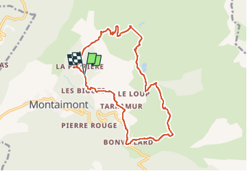
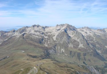
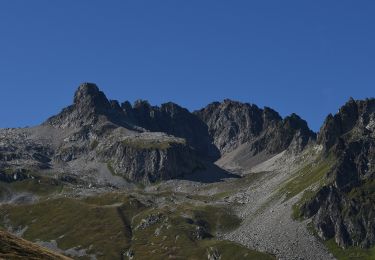
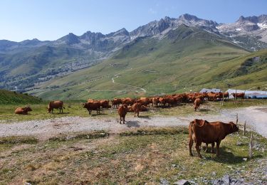
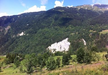
Ruta Senderismo de 8,9 km a descubrir en Auvergne-Rhône-Alpes, Saboya, Saint-François-Longchamp. Esta ruta ha sido propuesta por Delahalle.
Descripción
Belle randonnée au départ de La Perrière avec passage par la chapelle Ste marguerite et le lac du Loup. Par la suite, très beau sentier balcon permettant de voir le col de Chaussy et les nombreux hameaux de Montaimont dont certains vont être traversés. Attention, le sentier sur la route à gauche après le lac du Loup, avec un panneau indiquant Le Closet est peu marqué au début et nécessite de traverser le torrent un peu plus haut. par la suite, il est sans problème.
Localización
Comentarios
Excursiones cerca
![Excursión A pie Saint-François-Longchamp - Itinéraire de trail vert Le Sapin - Photo](https://media.geolcdn.com/t/375/260/75d11713-5eaa-4347-a63a-24768045895b.jpeg&format=jpg&maxdim=2)
![A pie A pie](https://static1.geolcdn.com/sitytour/trail-icons/100.png)
A pie
![](/images/other/stat-length.png)
![](https://static1.geolcdn.com/siteimages/upload/files/16400158638029165_repeat_loop_refresh_sync_direction_icon.png)
![Excursión A pie Saint-François-Longchamp - Itinéraire de trail bleu Le Taimonain - Photo](https://media.geolcdn.com/t/375/260/426c19c5-a85d-490e-9892-908e58951b2e.jpeg&format=jpg&maxdim=2)
![A pie A pie](https://static1.geolcdn.com/sitytour/trail-icons/100.png)
A pie
![](/images/other/stat-length.png)
![](https://static1.geolcdn.com/siteimages/upload/files/16400158638029165_repeat_loop_refresh_sync_direction_icon.png)
![Excursión A pie Saint-François-Longchamp - Itinéraire de trail noir Kilomètre vertical du Cheval Noir - Photo](https://media.geolcdn.com/t/375/260/e402ee96-fef3-4cbe-889a-479ec7063a83.jpeg&format=jpg&maxdim=2)
![A pie A pie](https://static1.geolcdn.com/sitytour/trail-icons/100.png)
A pie
![](/images/other/stat-length.png)
![](https://static1.geolcdn.com/siteimages/upload/files/16400158638029165_repeat_loop_refresh_sync_direction_icon.png)
![Excursión A pie Saint-François-Longchamp - Itinéraire de trail rouge Le Colombin - Photo](https://media.geolcdn.com/t/375/260/7765f6d2-c209-44a9-976d-d89f41e09634.jpeg&format=jpg&maxdim=2)
![A pie A pie](https://static1.geolcdn.com/sitytour/trail-icons/100.png)
A pie
![](/images/other/stat-length.png)
![](https://static1.geolcdn.com/siteimages/upload/files/16400158638029165_repeat_loop_refresh_sync_direction_icon.png)
![Excursión Senderismo Saint-François-Longchamp - rando 4 - Photo](https://media.geolcdn.com/t/375/260/ext.jpg?maxdim=2&url=https%3A%2F%2Fstatic1.geolcdn.com%2Fsiteimages%2Fupload%2Ffiles%2F1553511878bg_sport_marche.png)
![Senderismo Senderismo](https://static1.geolcdn.com/sitytour/trail-icons/101.png)
Senderismo
![](/images/other/stat-length.png)
![](https://static1.geolcdn.com/siteimages/upload/files/16400158638029165_repeat_loop_refresh_sync_direction_icon.png)
![Excursión Senderismo Saint-François-Longchamp - Saint François Longchamp-Lac Blanc et lac Bleu - Photo](https://media.geolcdn.com/t/375/260/3d85a8dd-b900-4bd5-88f6-7c0a2b5af230.jpg&format=jpg&maxdim=2)
![Senderismo Senderismo](https://static1.geolcdn.com/sitytour/trail-icons/101.png)
Senderismo
![](/images/other/stat-length.png)
![](https://static1.geolcdn.com/siteimages/upload/files/16400158638029165_repeat_loop_refresh_sync_direction_icon.png)
![Excursión Senderismo Saint-François-Longchamp - col montjoie 2258 m - Photo](https://media.geolcdn.com/t/375/260/456da3f4-244e-4578-91e6-d99d3412f893.jpg&format=jpg&maxdim=2)
![Senderismo Senderismo](https://static1.geolcdn.com/sitytour/trail-icons/101.png)
Senderismo
![](/images/other/stat-length.png)
![](https://static1.geolcdn.com/siteimages/upload/files/16400158638029165_repeat_loop_refresh_sync_direction_icon.png)
![Excursión Senderismo Saint-François-Longchamp - sentier des Pâquiers - Photo](https://media.geolcdn.com/t/375/260/ext.jpg?maxdim=2&url=https%3A%2F%2Fservices.sitytrail.com%2FGeolivesWS%2FDownloadMedia.ashx%3FTrailID%3D142610%26Media%3D20120729122510.jpg)
![Senderismo Senderismo](https://static1.geolcdn.com/sitytour/trail-icons/101.png)
Senderismo
![](/images/other/stat-length.png)
![](https://static1.geolcdn.com/siteimages/upload/files/16400158638029165_repeat_loop_refresh_sync_direction_icon.png)
![Excursión Bici eléctrica Sainte-Marie-de-Cuines - Glandon-19475609 - Photo](https://media.geolcdn.com/t/375/260/ext.jpg?maxdim=2&url=https%3A%2F%2Fstatic1.geolcdn.com%2Fsiteimages%2Fupload%2Ffiles%2F1524743154velo.jpg)
![Bici eléctrica Bici eléctrica](https://static1.geolcdn.com/sitytour/trail-icons/205.png)
Bici eléctrica
![](/images/other/stat-length.png)
![](https://static1.geolcdn.com/siteimages/upload/files/16400158638029165_repeat_loop_refresh_sync_direction_icon.png)