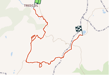
![](/images/other/stat-length.png)
![Excursión Senderismo Beaufort - BEAUFORTIN: DE TREICOL AU REFUGE DE PRESSET - Photo](https://media.geolcdn.com/t/1900/400/b55af32d-175e-4c65-8b45-e395808907f4.jpg&format=pjpeg&maxdim=2)
BEAUFORTIN: DE TREICOL AU REFUGE DE PRESSET
djeepee74
Usuario
![Longitud](/images/other/stat-length.png)
Longitud
9,1 km
![Altitud máxima](https://static1.geolcdn.com/siteimages/upload/files/1508320355ic_sort_altitude_max_24dp.png)
Altitud máxima
2559 m
![Desnivel positivo](https://static1.geolcdn.com/siteimages/upload/files/1508320355ic_sort_den_pos_24dp.png)
Desnivel positivo
946 m
![Km-Effort](/images/other/stat-length.png)
Km-Effort
19,1 km
![Altitud mínima](https://static1.geolcdn.com/siteimages/upload/files/1508320355ic_sort_altitude_min_24dp.png)
Altitud mínima
1706 m
![Desnivel negativo](https://static1.geolcdn.com/siteimages/upload/files/1508320355ic_sort_den_neg_24dp.png)
Desnivel negativo
162 m
![Boucle](https://static1.geolcdn.com/siteimages/upload/files/16400158638029165_repeat_loop_refresh_sync_direction_icon.png)
Boucle
No
Fecha de creación :
2022-07-30 08:59:01.234
Última modificación :
2022-08-02 09:59:11.407
![Senderismo](https://static1.geolcdn.com/sitytour/trail-icons/101.png)
3h10
Dificultad : Medio
![Escanee este código QR para abrir la excursión en la aplicación SityTrail](https://capi.geolives.com/qq0zvz2zws4bq2lad0pu/sitytour/trails/3335418/qr.png?size=200)
Aplicación GPS de excursión GRATIS
A propósito
Ruta Senderismo de 9,1 km a descubrir en Auvergne-Rhône-Alpes, Saboya, Beaufort. Esta ruta ha sido propuesta por djeepee74.
Descripción
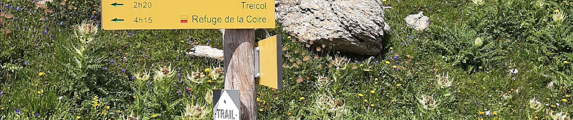
ALLER... live de Cris & Karine du 20220730
très belle randonnée dans un environnement splendide... encore 😁🤗
Localización
País:
France
Región :
Auvergne-Rhône-Alpes
Departamento/provincia :
Saboya
Municipio :
Beaufort
Localidad:
Unknown
Salida:(Dec)
Salida:(UTM)
315826 ; 5058938 (32T) N.
Comentarios
Excursiones cerca
![Excursión Senderismo Beaufort - Du refuge du Plan de la laie au refuge de la Croix du Bonhomme - Photo](https://media.geolcdn.com/t/375/260/ext.jpg?maxdim=2&url=https%3A%2F%2Fservices.sitytrail.com%2FGeolivesWS%2FDownloadMedia.ashx%3FTrailID%3D605207%26Media%3D510e5eef-7385-455b-8e69-ea984ac16f39.jpg)
![Senderismo Senderismo](https://static1.geolcdn.com/sitytour/trail-icons/101.png)
Du refuge du Plan de la laie au refuge de la Croix du Bonhomme
Senderismo
Medio
(1)
Beaufort,
Auvergne-Rhône-Alpes,
Saboya,
France
![](/images/other/stat-length.png)
8 km | 16 km-effort
4h 27min
![](https://static1.geolcdn.com/siteimages/upload/files/16400158638029165_repeat_loop_refresh_sync_direction_icon.png)
No
![Excursión Senderismo Aime-la-Plagne - 2024-09-08 Marche Tour Beaufortain Refuge Coire vers Refuge Presset - Photo](https://media.geolcdn.com/t/375/260/b0c8e42e-e06a-4d0e-aaaf-41f5a8616494.jpg&format=jpg&maxdim=2)
![Senderismo Senderismo](https://static1.geolcdn.com/sitytour/trail-icons/101.png)
2024-09-08 Marche Tour Beaufortain Refuge Coire vers Refuge Presset
Senderismo
Muy difícil
Aime-la-Plagne,
Auvergne-Rhône-Alpes,
Saboya,
France
![](/images/other/stat-length.png)
13,6 km | 26 km-effort
5h 48min
![](https://static1.geolcdn.com/siteimages/upload/files/16400158638029165_repeat_loop_refresh_sync_direction_icon.png)
No
![Excursión Senderismo La Plagne-Tarentaise - suuntoapp-Hiking-2024-09-09T06-09-09Z - Photo](https://media.geolcdn.com/t/375/260/b6087b8c-1dc3-46a1-846c-8446c87c1444.jpg&format=jpg&maxdim=2)
![Senderismo Senderismo](https://static1.geolcdn.com/sitytour/trail-icons/101.png)
suuntoapp-Hiking-2024-09-09T06-09-09Z
Senderismo
Muy difícil
La Plagne-Tarentaise,
Auvergne-Rhône-Alpes,
Saboya,
France
![](/images/other/stat-length.png)
13,6 km | 25 km-effort
5h 44min
![](https://static1.geolcdn.com/siteimages/upload/files/16400158638029165_repeat_loop_refresh_sync_direction_icon.png)
No
![Excursión Esquí de fondo Beaufort - Passage d'Arpire, col Bresson, brèche de Parozan - Photo](https://media.geolcdn.com/t/375/260/cef576dc-81b5-4e18-a375-2d133cd76090.jpg&format=jpg&maxdim=2)
![Esquí de fondo Esquí de fondo](https://static1.geolcdn.com/sitytour/trail-icons/503.png)
Passage d'Arpire, col Bresson, brèche de Parozan
Esquí de fondo
Difícil
Beaufort,
Auvergne-Rhône-Alpes,
Saboya,
France
![](/images/other/stat-length.png)
17,6 km | 39 km-effort
9h 4min
![](https://static1.geolcdn.com/siteimages/upload/files/16400158638029165_repeat_loop_refresh_sync_direction_icon.png)
Sí
![Excursión Senderismo Beaufort - lac de Presset et passeur de la Mintaz (belvédère de la Pierra Menta) - Photo](https://media.geolcdn.com/t/375/260/0e1a7432-483a-440c-958e-0a3e3d697f7b.jpg&format=jpg&maxdim=2)
![Senderismo Senderismo](https://static1.geolcdn.com/sitytour/trail-icons/101.png)
lac de Presset et passeur de la Mintaz (belvédère de la Pierra Menta)
Senderismo
Difícil
Beaufort,
Auvergne-Rhône-Alpes,
Saboya,
France
![](/images/other/stat-length.png)
11,6 km | 24 km-effort
2h 57min
![](https://static1.geolcdn.com/siteimages/upload/files/16400158638029165_repeat_loop_refresh_sync_direction_icon.png)
Sí
![Excursión Senderismo La Plagne-Tarentaise - Du refuge de Presset au refuge de la Coire - Photo](https://media.geolcdn.com/t/375/260/ext.jpg?maxdim=2&url=https%3A%2F%2Fservices.sitytrail.com%2FGeolivesWS%2FDownloadMedia.ashx%3FTrailID%3D612521%26Media%3D65c78503-17c1-4137-a504-eeeac73dd9ba.jpg)
![Senderismo Senderismo](https://static1.geolcdn.com/sitytour/trail-icons/101.png)
Du refuge de Presset au refuge de la Coire
Senderismo
Medio
La Plagne-Tarentaise,
Auvergne-Rhône-Alpes,
Saboya,
France
![](/images/other/stat-length.png)
9 km | 15,6 km-effort
5h 0min
![](https://static1.geolcdn.com/siteimages/upload/files/16400158638029165_repeat_loop_refresh_sync_direction_icon.png)
No
![Excursión Senderismo Beaufort - Ref de la Laie vers refuge du Presset - Photo](https://media.geolcdn.com/t/375/260/ext.jpg?maxdim=2&url=https%3A%2F%2Fstatic1.geolcdn.com%2Fsiteimages%2Fupload%2Ffiles%2F1553511878bg_sport_marche.png)
![Senderismo Senderismo](https://static1.geolcdn.com/sitytour/trail-icons/101.png)
Ref de la Laie vers refuge du Presset
Senderismo
Medio
(1)
Beaufort,
Auvergne-Rhône-Alpes,
Saboya,
France
![](/images/other/stat-length.png)
10,6 km | 19,8 km-effort
5h 17min
![](https://static1.geolcdn.com/siteimages/upload/files/16400158638029165_repeat_loop_refresh_sync_direction_icon.png)
No
![Excursión Senderismo Beaufort - Rocher du Vent 7,8 km -570 m + - Photo](https://media.geolcdn.com/t/375/260/9d77b27d-0052-43ba-aa7f-4b36e35a1567.jpg&format=jpg&maxdim=2)
![Senderismo Senderismo](https://static1.geolcdn.com/sitytour/trail-icons/101.png)
Rocher du Vent 7,8 km -570 m +
Senderismo
Difícil
Beaufort,
Auvergne-Rhône-Alpes,
Saboya,
France
![](/images/other/stat-length.png)
7,8 km | 15,3 km-effort
5h 40min
![](https://static1.geolcdn.com/siteimages/upload/files/16400158638029165_repeat_loop_refresh_sync_direction_icon.png)
Sí
![Excursión Senderismo Beaufort - Lac d’Amour - col du Coin 10 km -680 m dénivelé + - Photo](https://media.geolcdn.com/t/375/260/3b47f1f6-ac20-42ea-91ad-660067538617.jpg&format=jpg&maxdim=2)
![Senderismo Senderismo](https://static1.geolcdn.com/sitytour/trail-icons/101.png)
Lac d’Amour - col du Coin 10 km -680 m dénivelé +
Senderismo
Medio
Beaufort,
Auvergne-Rhône-Alpes,
Saboya,
France
![](/images/other/stat-length.png)
10,4 km | 19,6 km-effort
7h 5min
![](https://static1.geolcdn.com/siteimages/upload/files/16400158638029165_repeat_loop_refresh_sync_direction_icon.png)
Sí