![](/images/other/stat-length.png)
![Excursión Senderismo Le Haut-Bréda - Refuge de l'Oule - Croix et Lac du Léat - Photo](https://media.geolcdn.com/t/1900/400/078c0fe6-5867-4c5f-8f9e-655ab5779903.jpg&format=pjpeg&maxdim=2)
Refuge de l'Oule - Croix et Lac du Léat
GuyVachet
Usuario
![Longitud](/images/other/stat-length.png)
![Altitud máxima](https://static1.geolcdn.com/siteimages/upload/files/1508320355ic_sort_altitude_max_24dp.png)
![Desnivel positivo](https://static1.geolcdn.com/siteimages/upload/files/1508320355ic_sort_den_pos_24dp.png)
![Km-Effort](/images/other/stat-length.png)
![Altitud mínima](https://static1.geolcdn.com/siteimages/upload/files/1508320355ic_sort_altitude_min_24dp.png)
![Desnivel negativo](https://static1.geolcdn.com/siteimages/upload/files/1508320355ic_sort_den_neg_24dp.png)
![Boucle](https://static1.geolcdn.com/siteimages/upload/files/16400158638029165_repeat_loop_refresh_sync_direction_icon.png)
![Senderismo](https://static1.geolcdn.com/sitytour/trail-icons/101.png)
6h32
Dificultad : Muy difícil
![Escanee este código QR para abrir la excursión en la aplicación SityTrail](https://capi.geolives.com/qq0zvz2zws4bq2lad0pu/sitytour/trails/3333289/qr.png?size=200)
Aplicación GPS de excursión GRATIS
A propósito
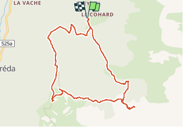
Ruta Senderismo de 11,5 km a descubrir en Auvergne-Rhône-Alpes, Isère, Le Haut-Bréda. Esta ruta ha sido propuesta por GuyVachet.
Descripción
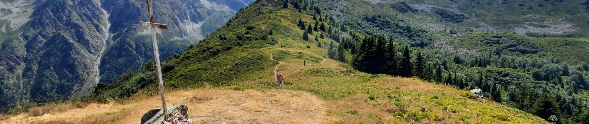
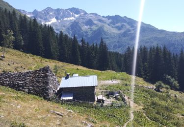
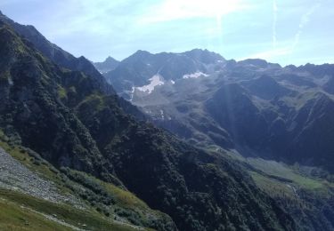
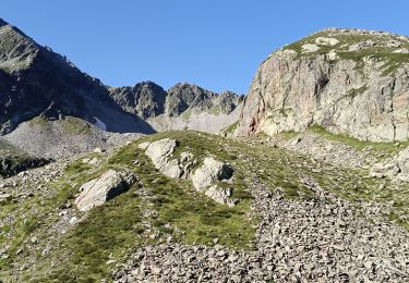
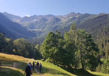
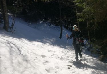
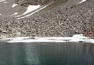
Boucle pour le refuge de l'Oule, la Pierre du Pin puis la Croix et Lac du Léat. La montée à partir du Gleyzin se fait bien en bénéficiant la fraîcheur du vallon pour déboucher au pied du refuge. Après un court-aller retour à celui-ci, la montée à la Pierre du Pin est plus exigeante mais là-aussi relativement abritée de la chaleur. A la Pierre du Pin, belle vue panoramique sur Belledonne et aussi la Chartreuse. La descente commence par la Croix du Léat et le Lac avant de repasser en forêt puis au Chalet du Bout, on trouve la descente sur le parking de départ.
Localización
Comentarios
Excursiones cerca
![Excursión Senderismo Le Haut-Bréda - Lac Blanc Lac de la Folle - Photo](https://media.geolcdn.com/t/375/260/f4e38b80-48fc-49d4-b675-d255436e858e.jpg&format=jpg&maxdim=2)
![Senderismo Senderismo](https://static1.geolcdn.com/sitytour/trail-icons/101.png)
Senderismo
![](/images/other/stat-length.png)
![](https://static1.geolcdn.com/siteimages/upload/files/16400158638029165_repeat_loop_refresh_sync_direction_icon.png)
![Excursión Senderismo Le Haut-Bréda - Lac de Moretan avec bivouac - Photo](https://media.geolcdn.com/t/375/260/3f6f6c9a-9eda-4898-9aca-c8a8ce663caf.jpg&format=jpg&maxdim=2)
![Senderismo Senderismo](https://static1.geolcdn.com/sitytour/trail-icons/101.png)
Senderismo
![](/images/other/stat-length.png)
![](https://static1.geolcdn.com/siteimages/upload/files/16400158638029165_repeat_loop_refresh_sync_direction_icon.png)
![Excursión Esquí de fondo Le Haut-Bréda - Col de Morétan - Photo](https://media.geolcdn.com/t/375/260/873ab7f9-f7ca-4112-a0d8-deee5e8e09db.jpg&format=jpg&maxdim=2)
![Esquí de fondo Esquí de fondo](https://static1.geolcdn.com/sitytour/trail-icons/503.png)
Esquí de fondo
![](/images/other/stat-length.png)
![](https://static1.geolcdn.com/siteimages/upload/files/16400158638029165_repeat_loop_refresh_sync_direction_icon.png)
![Excursión Senderismo Le Haut-Bréda - Montagne de Périoule - Photo](https://media.geolcdn.com/t/375/260/2f5383cd-a0ab-4c06-9cbc-7601a3f9dca7.jpg&format=jpg&maxdim=2)
![Senderismo Senderismo](https://static1.geolcdn.com/sitytour/trail-icons/101.png)
Senderismo
![](/images/other/stat-length.png)
![](https://static1.geolcdn.com/siteimages/upload/files/16400158638029165_repeat_loop_refresh_sync_direction_icon.png)
![Excursión Senderismo Le Haut-Bréda - 2jours dans la vallée de la Valloire - Photo](https://media.geolcdn.com/t/375/260/9e9cf3b1-838d-469b-96fa-b30ad43a1a59.jpg&format=jpg&maxdim=2)
![Senderismo Senderismo](https://static1.geolcdn.com/sitytour/trail-icons/101.png)
Senderismo
![](/images/other/stat-length.png)
![](https://static1.geolcdn.com/siteimages/upload/files/16400158638029165_repeat_loop_refresh_sync_direction_icon.png)
![Excursión Senderismo Le Haut-Bréda - Lac et Croix du Léat - Photo](https://media.geolcdn.com/t/375/260/baf05127-eb6f-4a23-a9cc-3889b7723c4a.jpg&format=jpg&maxdim=2)
![Senderismo Senderismo](https://static1.geolcdn.com/sitytour/trail-icons/101.png)
Senderismo
![](/images/other/stat-length.png)
![](https://static1.geolcdn.com/siteimages/upload/files/16400158638029165_repeat_loop_refresh_sync_direction_icon.png)
![Excursión Raquetas de nieve Le Haut-Bréda - lac blanc de la grande valloire - Photo](https://media.geolcdn.com/t/375/260/2557f174-3a45-4bf5-8fe0-a92f7b11b384.jpg&format=jpg&maxdim=2)
![Raquetas de nieve Raquetas de nieve](https://static1.geolcdn.com/sitytour/trail-icons/504.png)
Raquetas de nieve
![](/images/other/stat-length.png)
![](https://static1.geolcdn.com/siteimages/upload/files/16400158638029165_repeat_loop_refresh_sync_direction_icon.png)
![Excursión A pie Le Haut-Bréda - Tour Pays Allevard - Photo](https://media.geolcdn.com/t/375/260/0a5c4a99-9cde-4ae9-a3b1-f2c7b44e7d78.jpeg&format=jpg&maxdim=2)
![A pie A pie](https://static1.geolcdn.com/sitytour/trail-icons/100.png)
A pie
![](/images/other/stat-length.png)
![](https://static1.geolcdn.com/siteimages/upload/files/16400158638029165_repeat_loop_refresh_sync_direction_icon.png)
![Excursión Senderismo Le Haut-Bréda - Lacs de la Valloire - Photo](https://media.geolcdn.com/t/375/260/ext.jpg?maxdim=2&url=https%3A%2F%2Fservices.sitytrail.com%2FGeolivesWS%2FDownloadMedia.ashx%3FTrailID%3D444560%26Media%3Dfix__20150712135131.jpg)
![Senderismo Senderismo](https://static1.geolcdn.com/sitytour/trail-icons/101.png)
Senderismo
![](/images/other/stat-length.png)
![](https://static1.geolcdn.com/siteimages/upload/files/16400158638029165_repeat_loop_refresh_sync_direction_icon.png)