![](/images/other/stat-length.png)
![Excursión Senderismo Francheleins - D'un chateau à l'autre autour de Francheleins - Photo](https://media.geolcdn.com/t/1900/400/ext.pjpeg?maxdim=2&url=https%3A%2F%2Fstatic1.geolcdn.com%2Fsiteimages%2Fupload%2Ffiles%2F1553511878bg_sport_marche.png)
D'un chateau à l'autre autour de Francheleins
galain
Usuario
![Longitud](/images/other/stat-length.png)
Longitud
13,1 km
![Altitud máxima](https://static1.geolcdn.com/siteimages/upload/files/1508320355ic_sort_altitude_max_24dp.png)
Altitud máxima
274 m
![Desnivel positivo](https://static1.geolcdn.com/siteimages/upload/files/1508320355ic_sort_den_pos_24dp.png)
Desnivel positivo
126 m
![Km-Effort](/images/other/stat-length.png)
Km-Effort
14,8 km
![Altitud mínima](https://static1.geolcdn.com/siteimages/upload/files/1508320355ic_sort_altitude_min_24dp.png)
Altitud mínima
180 m
![Desnivel negativo](https://static1.geolcdn.com/siteimages/upload/files/1508320355ic_sort_den_neg_24dp.png)
Desnivel negativo
126 m
![Boucle](https://static1.geolcdn.com/siteimages/upload/files/16400158638029165_repeat_loop_refresh_sync_direction_icon.png)
Boucle
Sí
Fecha de creación :
2015-10-25 00:00:00.0
Última modificación :
2015-10-25 00:00:00.0
![Senderismo](https://static1.geolcdn.com/sitytour/trail-icons/101.png)
3h15
Dificultad : Medio
![Escanee este código QR para abrir la excursión en la aplicación SityTrail](https://capi.geolives.com/qq0zvz2zws4bq2lad0pu/sitytour/trails/332228/qr.png?size=200)
Aplicación GPS de excursión GRATIS
A propósito
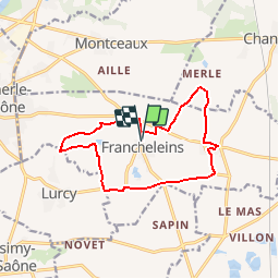
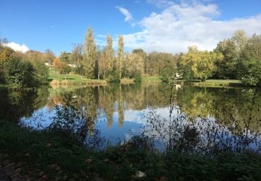
Ruta Senderismo de 13,1 km a descubrir en Auvergne-Rhône-Alpes, Ain, Francheleins. Esta ruta ha sido propuesta por galain.
Descripción
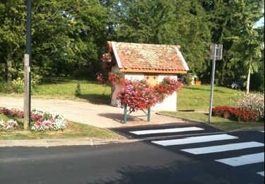
vu dans le progrès du 07/03/2013...rando faite le 11/10/15 avec Totof...ballade sympa mais souvent sur la route.
Localización
País:
France
Región :
Auvergne-Rhône-Alpes
Departamento/provincia :
Ain
Municipio :
Francheleins
Localidad:
Francheleins
Salida:(Dec)
Salida:(UTM)
639862 ; 5103920 (31T) N.
Comentarios
Excursiones cerca
![Excursión Senderismo Lurcy - Lurcy (16 km - D. 134 m) - Photo](https://media.geolcdn.com/t/375/260/e2042645-0d0c-4f8d-a036-e57dec048f59.jpg&format=jpg&maxdim=2)
![Senderismo Senderismo](https://static1.geolcdn.com/sitytour/trail-icons/101.png)
Lurcy (16 km - D. 134 m)
Senderismo
Difícil
Lurcy,
Auvergne-Rhône-Alpes,
Ain,
France
![](/images/other/stat-length.png)
16,2 km | 18 km-effort
4h 57min
![](https://static1.geolcdn.com/siteimages/upload/files/16400158638029165_repeat_loop_refresh_sync_direction_icon.png)
Sí
![Excursión Senderismo Chaleins - chaneins - Photo](https://media.geolcdn.com/t/375/260/ext.jpg?maxdim=2&url=https%3A%2F%2Fservices.sitytrail.com%2FGeolivesWS%2FDownloadMedia.ashx%3FTrailID%3D266784%26Media%3Dfix__20140405115211.jpg)
![Senderismo Senderismo](https://static1.geolcdn.com/sitytour/trail-icons/101.png)
chaneins
Senderismo
Fácil
Chaleins,
Auvergne-Rhône-Alpes,
Ain,
France
![](/images/other/stat-length.png)
12,8 km | 14,3 km-effort
4h 2min
![](https://static1.geolcdn.com/siteimages/upload/files/16400158638029165_repeat_loop_refresh_sync_direction_icon.png)
Sí
![Excursión Senderismo Chaleins - chaneins - Photo](https://media.geolcdn.com/t/375/260/ext.jpg?maxdim=2&url=https%3A%2F%2Fservices.sitytrail.com%2FGeolivesWS%2FDownloadMedia.ashx%3FTrailID%3D263439%26Media%3Dfix__20140405150716.jpg)
![Senderismo Senderismo](https://static1.geolcdn.com/sitytour/trail-icons/101.png)
chaneins
Senderismo
Fácil
Chaleins,
Auvergne-Rhône-Alpes,
Ain,
France
![](/images/other/stat-length.png)
12,8 km | 14,3 km-effort
4h 2min
![](https://static1.geolcdn.com/siteimages/upload/files/16400158638029165_repeat_loop_refresh_sync_direction_icon.png)
Sí
![Excursión Bicicleta Montmerle-sur-Saône - la tousse - Photo](https://media.geolcdn.com/t/375/260/ext.jpg?maxdim=2&url=https%3A%2F%2Fservices.sitytrail.com%2FGeolivesWS%2FDownloadMedia.ashx%3FTrailID%3D44597%26Media%3Dimage2.jpg)
![Bicicleta Bicicleta](https://static1.geolcdn.com/sitytour/trail-icons/200.png)
la tousse
Bicicleta
Muy fácil
Montmerle-sur-Saône,
Auvergne-Rhône-Alpes,
Ain,
France
![](/images/other/stat-length.png)
49 km | 55 km-effort
Desconocido
![](https://static1.geolcdn.com/siteimages/upload/files/16400158638029165_repeat_loop_refresh_sync_direction_icon.png)
No
![Excursión Caballo Montmerle-sur-Saône - Beau Dimanche à Montmerle sur Saône - Photo](https://media.geolcdn.com/t/375/260/602201c6-346f-409e-a295-10aa730b2c46.png&format=jpg&maxdim=2)
![Caballo Caballo](https://static1.geolcdn.com/sitytour/trail-icons/300.png)
Beau Dimanche à Montmerle sur Saône
Caballo
Medio
Montmerle-sur-Saône,
Auvergne-Rhône-Alpes,
Ain,
France
![](/images/other/stat-length.png)
33 km | 38 km-effort
Desconocido
![](https://static1.geolcdn.com/siteimages/upload/files/16400158638029165_repeat_loop_refresh_sync_direction_icon.png)
Sí
![Senderismo Senderismo](https://static1.geolcdn.com/sitytour/trail-icons/101.png)
rando tarot
Senderismo
Medio
Messimy-sur-Saône,
Auvergne-Rhône-Alpes,
Ain,
France
![](/images/other/stat-length.png)
11,3 km | 12,6 km-effort
1h 54min
![](https://static1.geolcdn.com/siteimages/upload/files/16400158638029165_repeat_loop_refresh_sync_direction_icon.png)
Sí
![Senderismo Senderismo](https://static1.geolcdn.com/sitytour/trail-icons/101.png)
Messimy - Messimy (Ain)
Senderismo
Medio
Messimy-sur-Saône,
Auvergne-Rhône-Alpes,
Ain,
France
![](/images/other/stat-length.png)
26 km | 30 km-effort
7h 0min
![](https://static1.geolcdn.com/siteimages/upload/files/16400158638029165_repeat_loop_refresh_sync_direction_icon.png)
Sí
![Excursión Paseo ecuestre Montmerle-sur-Saône - Beau Dimanche Cheval en Chalaronne Dombes Saône Vallée - Photo](https://media.geolcdn.com/t/375/260/ca14b500-3b6b-4c59-a19d-5a8458f22ac1.jpg&format=jpg&maxdim=2)
![Paseo ecuestre Paseo ecuestre](https://static1.geolcdn.com/sitytour/trail-icons/301.png)
Beau Dimanche Cheval en Chalaronne Dombes Saône Vallée
Paseo ecuestre
Medio
Montmerle-sur-Saône,
Auvergne-Rhône-Alpes,
Ain,
France
![](/images/other/stat-length.png)
33 km | 37 km-effort
3h 43min
![](https://static1.geolcdn.com/siteimages/upload/files/16400158638029165_repeat_loop_refresh_sync_direction_icon.png)
Sí
![Excursión Bicicleta Montmerle-sur-Saône - 2010-08-08 - 20h02m23 - Photo](https://media.geolcdn.com/t/375/260/ext.jpg?maxdim=2&url=https%3A%2F%2Fservices.sitytrail.com%2FGeolivesWS%2FDownloadMedia.ashx%3FTrailID%3D43606%26Media%3Dimage0.jpg)
![Bicicleta Bicicleta](https://static1.geolcdn.com/sitytour/trail-icons/200.png)
2010-08-08 - 20h02m23
Bicicleta
Muy fácil
Montmerle-sur-Saône,
Auvergne-Rhône-Alpes,
Ain,
France
![](/images/other/stat-length.png)
40 km | 45 km-effort
Desconocido
![](https://static1.geolcdn.com/siteimages/upload/files/16400158638029165_repeat_loop_refresh_sync_direction_icon.png)
Sí