![](/images/other/stat-length.png)
![Excursión Senderismo Sexten - Sesto - Helm - Monte Helmo 2434m - Photo](https://media.geolcdn.com/t/1900/400/0d14100c-cb7e-406a-8a75-137040be2699.jpg&format=pjpeg&maxdim=2)
Helm - Monte Helmo 2434m
VacheKiri67
Usuario
![Longitud](/images/other/stat-length.png)
![Altitud máxima](https://static1.geolcdn.com/siteimages/upload/files/1508320355ic_sort_altitude_max_24dp.png)
![Desnivel positivo](https://static1.geolcdn.com/siteimages/upload/files/1508320355ic_sort_den_pos_24dp.png)
![Km-Effort](/images/other/stat-length.png)
![Altitud mínima](https://static1.geolcdn.com/siteimages/upload/files/1508320355ic_sort_altitude_min_24dp.png)
![Desnivel negativo](https://static1.geolcdn.com/siteimages/upload/files/1508320355ic_sort_den_neg_24dp.png)
![Boucle](https://static1.geolcdn.com/siteimages/upload/files/16400158638029165_repeat_loop_refresh_sync_direction_icon.png)
![Senderismo](https://static1.geolcdn.com/sitytour/trail-icons/101.png)
4h39
Dificultad : Medio
![Escanee este código QR para abrir la excursión en la aplicación SityTrail](https://capi.geolives.com/qq0zvz2zws4bq2lad0pu/sitytour/trails/3319854/qr.png?size=200)
Aplicación GPS de excursión GRATIS
A propósito
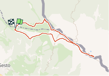
Ruta Senderismo de 9,8 km a descubrir en Trentino-Alto Adigio, Bolzano - Bozen, Sexten - Sesto. Esta ruta ha sido propuesta por VacheKiri67.
Descripción
Faite le 17/07/2022.
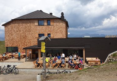
Montée au sommet par télécabine depuis Obervierschach-Versciaco di Sopra. Autre possibilité depuis Sexten-Sesto.
Parcours : HelmRestaurant 2041m, Hahnspielhütte 2150m, Sillianer Hütte 2447m, retour par le sommet du Helm 2434m et ensuite le balisage 20.
Le passage par le 20 est assez délicat : en descente raide, fermé par la végétation car peu parcouru. Nous conseillons donc de prendre le balisage 4 vers la Hahnspielhütte.
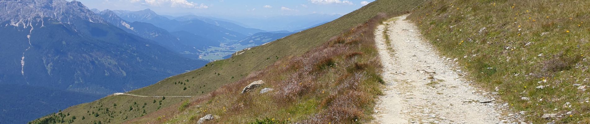
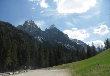
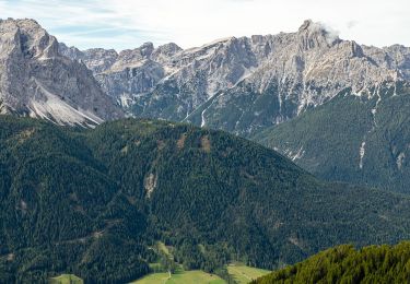
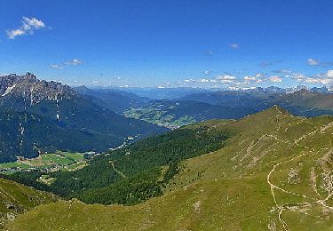
Magnifique panorama depuis le Helm.
Localización
Comentarios
Excursiones cerca
![Excursión Senderismo Innichen - San Candido - J1 Refuge Dreischusterhütte - Photo](https://media.geolcdn.com/t/375/260/ca8636b3-63c3-4f18-b60d-193a3baacd98.jpg&format=jpg&maxdim=2)
![Senderismo Senderismo](https://static1.geolcdn.com/sitytour/trail-icons/101.png)
Senderismo
![](/images/other/stat-length.png)
![](https://static1.geolcdn.com/siteimages/upload/files/16400158638029165_repeat_loop_refresh_sync_direction_icon.png)
![Excursión A pie Innichen - San Candido - IT-2 - Photo](https://media.geolcdn.com/t/375/260/5ead99e5-db73-4f0e-960c-094c5ea0231d.jpeg&format=jpg&maxdim=2)
![A pie A pie](https://static1.geolcdn.com/sitytour/trail-icons/100.png)
A pie
![](/images/other/stat-length.png)
![](https://static1.geolcdn.com/siteimages/upload/files/16400158638029165_repeat_loop_refresh_sync_direction_icon.png)
![Excursión A pie Sexten - Sesto - IT-3 - Photo](https://media.geolcdn.com/t/375/260/8f49cf67-8f0a-440e-bd20-facd4d2c50b5.jpeg&format=jpg&maxdim=2)
![A pie A pie](https://static1.geolcdn.com/sitytour/trail-icons/100.png)
A pie
![](/images/other/stat-length.png)
![](https://static1.geolcdn.com/siteimages/upload/files/16400158638029165_repeat_loop_refresh_sync_direction_icon.png)
![Excursión A pie Sexten - Sesto - IT-12A - Photo](https://media.geolcdn.com/t/375/260/a7312989-015a-4a30-999e-6fe83356a1b6.jpeg&format=jpg&maxdim=2)
![A pie A pie](https://static1.geolcdn.com/sitytour/trail-icons/100.png)
A pie
![](/images/other/stat-length.png)
![](https://static1.geolcdn.com/siteimages/upload/files/16400158638029165_repeat_loop_refresh_sync_direction_icon.png)
![Excursión A pie Sexten - Sesto - IT-12 - Photo](https://media.geolcdn.com/t/375/260/f66ad25d-5715-4d84-ae0c-55700da05aed.jpeg&format=jpg&maxdim=2)
![A pie A pie](https://static1.geolcdn.com/sitytour/trail-icons/100.png)
A pie
![](/images/other/stat-length.png)
![](https://static1.geolcdn.com/siteimages/upload/files/16400158638029165_repeat_loop_refresh_sync_direction_icon.png)
![Excursión A pie Sexten - Sesto - AT-20 - Photo](https://media.geolcdn.com/t/375/260/4afdf6d8-bf3a-4430-b8c7-7c9c89e4683e.jpeg&format=jpg&maxdim=2)
![A pie A pie](https://static1.geolcdn.com/sitytour/trail-icons/100.png)
A pie
![](/images/other/stat-length.png)
![](https://static1.geolcdn.com/siteimages/upload/files/16400158638029165_repeat_loop_refresh_sync_direction_icon.png)
![Excursión A pie Innichen - San Candido - IT-8 - Photo](https://media.geolcdn.com/t/375/260/cb4fcf2c-b2f0-4290-b4fc-30fc5d4131e0.jpeg&format=jpg&maxdim=2)
![A pie A pie](https://static1.geolcdn.com/sitytour/trail-icons/100.png)
A pie
![](/images/other/stat-length.png)
![](https://static1.geolcdn.com/siteimages/upload/files/16400158638029165_repeat_loop_refresh_sync_direction_icon.png)
![Excursión A pie Sexten - Sesto - IT-1 - Photo](https://media.geolcdn.com/t/375/260/6ec320c2-92d6-4406-8c8c-658128b76d77.jpeg&format=jpg&maxdim=2)
![A pie A pie](https://static1.geolcdn.com/sitytour/trail-icons/100.png)
A pie
![](/images/other/stat-length.png)
![](https://static1.geolcdn.com/siteimages/upload/files/16400158638029165_repeat_loop_refresh_sync_direction_icon.png)
![Excursión A pie Sexten - Sesto - IT-105A - Photo](https://media.geolcdn.com/t/375/260/c23e61e3-e050-4106-8813-1e095bdd574f.jpeg&format=jpg&maxdim=2)
![A pie A pie](https://static1.geolcdn.com/sitytour/trail-icons/100.png)
A pie
![](/images/other/stat-length.png)
![](https://static1.geolcdn.com/siteimages/upload/files/16400158638029165_repeat_loop_refresh_sync_direction_icon.png)