![](/images/other/stat-length.png)
![Excursión Senderismo Val-Cenis - Savoie_Barrage-du-Mont-Cenis=>Fort-de-Variselle - Photo](https://media.geolcdn.com/t/1900/400/36826a87-c81d-464b-bf46-c61bb879976c.jpg&format=pjpeg&maxdim=2)
Savoie_Barrage-du-Mont-Cenis=>Fort-de-Variselle
BMorin91470
Usuario
![Longitud](/images/other/stat-length.png)
![Altitud máxima](https://static1.geolcdn.com/siteimages/upload/files/1508320355ic_sort_altitude_max_24dp.png)
![Desnivel positivo](https://static1.geolcdn.com/siteimages/upload/files/1508320355ic_sort_den_pos_24dp.png)
![Km-Effort](/images/other/stat-length.png)
![Altitud mínima](https://static1.geolcdn.com/siteimages/upload/files/1508320355ic_sort_altitude_min_24dp.png)
![Desnivel negativo](https://static1.geolcdn.com/siteimages/upload/files/1508320355ic_sort_den_neg_24dp.png)
![Boucle](https://static1.geolcdn.com/siteimages/upload/files/16400158638029165_repeat_loop_refresh_sync_direction_icon.png)
![Senderismo](https://static1.geolcdn.com/sitytour/trail-icons/101.png)
2h44
Dificultad : Fácil
![Escanee este código QR para abrir la excursión en la aplicación SityTrail](https://capi.geolives.com/qq0zvz2zws4bq2lad0pu/sitytour/trails/3317405/qr.png?size=200)
Aplicación GPS de excursión GRATIS
A propósito
Ruta Senderismo de 5,7 km a descubrir en Auvergne-Rhône-Alpes, Saboya, Val-Cenis. Esta ruta ha sido propuesta por BMorin91470.
Descripción
Randonnée effectuée le 15/07/2022
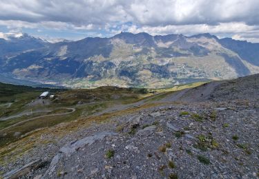
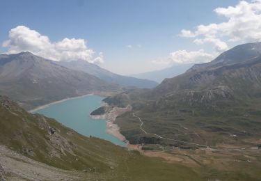
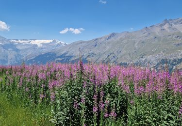
Petite randonnée courte et facile avec un superbe point de vue sur le lac du Mont-Cenis et ses alentours.
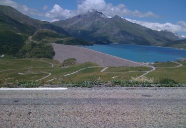
Départ depuis le parking au bout du barrage (côté Est).
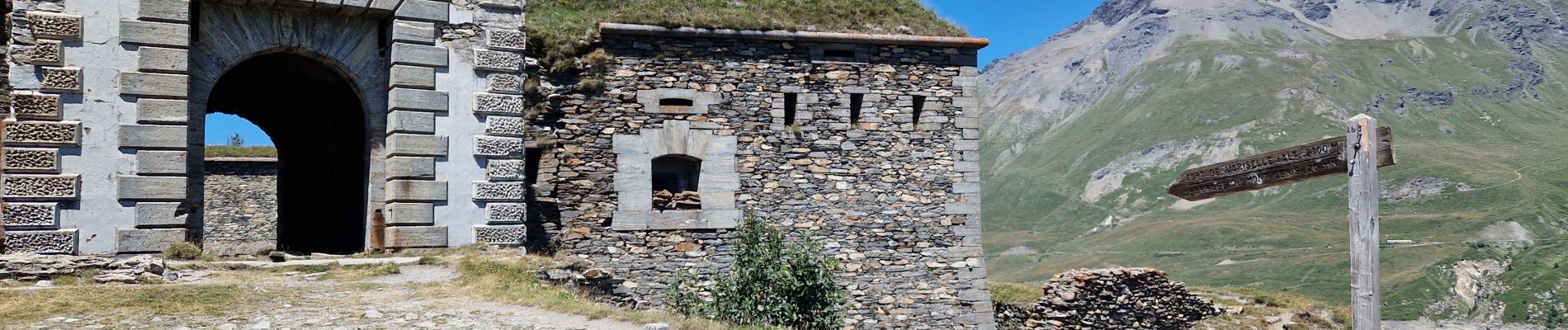
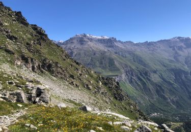
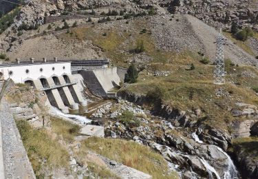
Traversée du barrage (à pied) et montée au Fort de Variselle.
Descente et retour par le même itinéraire (légère variante raccourcie à la descente du fort).
Localización
Comentarios
Excursiones cerca
![Excursión sport Val-Cenis - L’ancien fort de la Turra - Photo](https://media.geolcdn.com/t/375/260/2f372af5-3d13-4f3d-be22-d2d73efaca61.jpg&format=jpg&maxdim=2)
sport
![](/images/other/stat-length.png)
![](https://static1.geolcdn.com/siteimages/upload/files/16400158638029165_repeat_loop_refresh_sync_direction_icon.png)
![Excursión Senderismo Val-Cenis - Montcenis lac fort de la Tura - Photo](https://media.geolcdn.com/t/375/260/03903eba-f11b-41f0-bc93-d99cacc6c53d.jpg&format=jpg&maxdim=2)
![Senderismo Senderismo](https://static1.geolcdn.com/sitytour/trail-icons/101.png)
Senderismo
![](/images/other/stat-length.png)
![](https://static1.geolcdn.com/siteimages/upload/files/16400158638029165_repeat_loop_refresh_sync_direction_icon.png)
![Excursión Senderismo Val-Cenis - Col de la Met et Lac de l'Arcelle au départ du télésiège de Solert - Photo](https://media.geolcdn.com/t/375/260/fc51f4c9-cabd-4b7a-83d2-604413b6e3fa.jpg&format=jpg&maxdim=2)
![Senderismo Senderismo](https://static1.geolcdn.com/sitytour/trail-icons/101.png)
Senderismo
![](/images/other/stat-length.png)
![](https://static1.geolcdn.com/siteimages/upload/files/16400158638029165_repeat_loop_refresh_sync_direction_icon.png)
![Excursión Senderismo Val-Cenis - Le Fort de la Turra - Photo](https://media.geolcdn.com/t/375/260/fb7e4b15-499e-46a6-93e3-9848cd5c0804.jpg&format=jpg&maxdim=2)
![Senderismo Senderismo](https://static1.geolcdn.com/sitytour/trail-icons/101.png)
Senderismo
![](/images/other/stat-length.png)
![](https://static1.geolcdn.com/siteimages/upload/files/16400158638029165_repeat_loop_refresh_sync_direction_icon.png)
![Excursión Senderismo Val-Cenis - fort de la Turra - col de la Beccia - Photo](https://media.geolcdn.com/t/375/260/519bc2cf-9575-4c95-8b89-a32fb03a43b6.jpg&format=jpg&maxdim=2)
![Senderismo Senderismo](https://static1.geolcdn.com/sitytour/trail-icons/101.png)
Senderismo
![](/images/other/stat-length.png)
![](https://static1.geolcdn.com/siteimages/upload/files/16400158638029165_repeat_loop_refresh_sync_direction_icon.png)
![Excursión Senderismo Val-Cenis - Savoie_Val-Cenis_Lac de l'Arcelle - Photo](https://media.geolcdn.com/t/375/260/94347fc6-b8c5-42c0-a18f-2fed8afa226d.jpg&format=jpg&maxdim=2)
![Senderismo Senderismo](https://static1.geolcdn.com/sitytour/trail-icons/101.png)
Senderismo
![](/images/other/stat-length.png)
![](https://static1.geolcdn.com/siteimages/upload/files/16400158638029165_repeat_loop_refresh_sync_direction_icon.png)
![Excursión Senderismo Val-Cenis - Mont Giusalet - Photo](https://media.geolcdn.com/t/375/260/b8d02cf7-fe95-4e1a-a346-e2b3a0da8597.jpg&format=jpg&maxdim=2)
![Senderismo Senderismo](https://static1.geolcdn.com/sitytour/trail-icons/101.png)
Senderismo
![](/images/other/stat-length.png)
![](https://static1.geolcdn.com/siteimages/upload/files/16400158638029165_repeat_loop_refresh_sync_direction_icon.png)
![Excursión A pie Val-Cenis - Sentier des 2000 - Photo](https://media.geolcdn.com/t/375/260/c55d6407-6f9a-4af4-9066-39f4ffb813b9.jpeg&format=jpg&maxdim=2)
![A pie A pie](https://static1.geolcdn.com/sitytour/trail-icons/100.png)
A pie
![](/images/other/stat-length.png)
![](https://static1.geolcdn.com/siteimages/upload/files/16400158638029165_repeat_loop_refresh_sync_direction_icon.png)
![Excursión A pie Val-Cenis - IT-581 - Photo](https://media.geolcdn.com/t/375/260/73c89b54-e860-4060-8f37-d1fcf8ab2554.jpeg&format=jpg&maxdim=2)
![A pie A pie](https://static1.geolcdn.com/sitytour/trail-icons/100.png)
A pie
![](/images/other/stat-length.png)
![](https://static1.geolcdn.com/siteimages/upload/files/16400158638029165_repeat_loop_refresh_sync_direction_icon.png)