![](/images/other/stat-length.png)
![Excursión Senderismo Rochesson - ROCHESSON ... sur les hateurs. - Photo](https://media.geolcdn.com/t/1900/400/ext.pjpeg?maxdim=2&url=https%3A%2F%2Fmedia.geolcdn.com%2Ff%2Ff6b91085-2bc2-40cf-b38e-3cbcb1e0ce83.jpg)
ROCHESSON ... sur les hateurs.
GerardBouche
Usuario
![Longitud](/images/other/stat-length.png)
Longitud
15,6 km
![Altitud máxima](https://static1.geolcdn.com/siteimages/upload/files/1508320355ic_sort_altitude_max_24dp.png)
Altitud máxima
1017 m
![Desnivel positivo](https://static1.geolcdn.com/siteimages/upload/files/1508320355ic_sort_den_pos_24dp.png)
Desnivel positivo
609 m
![Km-Effort](/images/other/stat-length.png)
Km-Effort
24 km
![Altitud mínima](https://static1.geolcdn.com/siteimages/upload/files/1508320355ic_sort_altitude_min_24dp.png)
Altitud mínima
515 m
![Desnivel negativo](https://static1.geolcdn.com/siteimages/upload/files/1508320355ic_sort_den_neg_24dp.png)
Desnivel negativo
606 m
![Boucle](https://static1.geolcdn.com/siteimages/upload/files/16400158638029165_repeat_loop_refresh_sync_direction_icon.png)
Boucle
Sí
Fecha de creación :
2022-07-10 12:56:43.032
Última modificación :
2022-07-10 15:18:29.546
![Senderismo](https://static1.geolcdn.com/sitytour/trail-icons/101.png)
1h56
Dificultad : Difícil
![Escanee este código QR para abrir la excursión en la aplicación SityTrail](https://capi.geolives.com/qq0zvz2zws4bq2lad0pu/sitytour/trails/3311358/qr.png?size=200)
Aplicación GPS de excursión GRATIS
A propósito
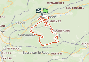
Ruta Senderismo de 15,6 km a descubrir en Gran Este, Vosgos, Rochesson. Esta ruta ha sido propuesta por GerardBouche.
Descripción
Un parcours vtt plutôt technique ... montée dans la grosse caillasse et la descente par de petits sentiers avec tronc d'arbres, portail et barbelés pour protection bétail !
Localización
País:
France
Región :
Gran Este
Departamento/provincia :
Vosgos
Municipio :
Rochesson
Localidad:
Unknown
Salida:(Dec)
Salida:(UTM)
334253 ; 5321237 (32U) N.
Comentarios
Excursiones cerca
![Excursión Senderismo Sapois - La Cascade de la Pissoire - Photo](https://media.geolcdn.com/t/375/260/ext.jpg?maxdim=2&url=https%3A%2F%2Fservices.sitytrail.com%2FGeolivesWS%2FDownloadMedia.ashx%3FTrailID%3D110286%26Media%3D5680_3.jpg)
![Senderismo Senderismo](https://static1.geolcdn.com/sitytour/trail-icons/101.png)
La Cascade de la Pissoire
Senderismo
Medio
(2)
Sapois,
Gran Este,
Vosgos,
France
![](/images/other/stat-length.png)
6,3 km | 8,9 km-effort
2h 0min
![](https://static1.geolcdn.com/siteimages/upload/files/16400158638029165_repeat_loop_refresh_sync_direction_icon.png)
Sí
![Excursión Senderismo Sapois - La Cascade de la Pissoire - Photo](https://media.geolcdn.com/t/375/260/ext.jpg?maxdim=2&url=https%3A%2F%2Fstatic1.geolcdn.com%2Fsiteimages%2Fupload%2Ffiles%2F1553511878bg_sport_marche.png)
![Senderismo Senderismo](https://static1.geolcdn.com/sitytour/trail-icons/101.png)
La Cascade de la Pissoire
Senderismo
Fácil
(3)
Sapois,
Gran Este,
Vosgos,
France
![](/images/other/stat-length.png)
6,3 km | 8,9 km-effort
1h 40min
![](https://static1.geolcdn.com/siteimages/upload/files/16400158638029165_repeat_loop_refresh_sync_direction_icon.png)
Sí
![Excursión Paseo ecuestre Gerbamont - 2022-06-05 Rando CVA Gerbamont Dommartin les Remiremont - Photo](https://media.geolcdn.com/t/375/260/ext.jpg?maxdim=2&url=https%3A%2F%2Fmedia.geolcdn.com%2Ff%2Ffd6e9bbc-68c7-4aa5-ac35-74c2c082f858.jpg)
![Paseo ecuestre Paseo ecuestre](https://static1.geolcdn.com/sitytour/trail-icons/301.png)
2022-06-05 Rando CVA Gerbamont Dommartin les Remiremont
Paseo ecuestre
Difícil
Gerbamont,
Gran Este,
Vosgos,
France
![](/images/other/stat-length.png)
24 km | 34 km-effort
5h 10min
![](https://static1.geolcdn.com/siteimages/upload/files/16400158638029165_repeat_loop_refresh_sync_direction_icon.png)
No
![Excursión Paseo ecuestre Gerbamont - 2022-06-04 Rando CVA Gerbamont Boucle Foret de Noire Goutte - Photo](https://media.geolcdn.com/t/375/260/ext.jpg?maxdim=2&url=https%3A%2F%2Fmedia.geolcdn.com%2Ff%2F44bce39b-ceb9-4dae-b553-730e48ff9ece.jpg)
![Paseo ecuestre Paseo ecuestre](https://static1.geolcdn.com/sitytour/trail-icons/301.png)
2022-06-04 Rando CVA Gerbamont Boucle Foret de Noire Goutte
Paseo ecuestre
Muy difícil
Gerbamont,
Gran Este,
Vosgos,
France
![](/images/other/stat-length.png)
31 km | 43 km-effort
6h 2min
![](https://static1.geolcdn.com/siteimages/upload/files/16400158638029165_repeat_loop_refresh_sync_direction_icon.png)
Sí
![Excursión Senderismo Cornimont - Croix des Moinats - Photo](https://media.geolcdn.com/t/375/260/ext.jpg?maxdim=2&url=https%3A%2F%2Fmedia.geolcdn.com%2Ff%2Fca2e91a2-4aa7-4b64-a421-a0f91eabaf46.jpg)
![Senderismo Senderismo](https://static1.geolcdn.com/sitytour/trail-icons/101.png)
Croix des Moinats
Senderismo
Fácil
Cornimont,
Gran Este,
Vosgos,
France
![](/images/other/stat-length.png)
5,7 km | 7,6 km-effort
1h 15min
![](https://static1.geolcdn.com/siteimages/upload/files/16400158638029165_repeat_loop_refresh_sync_direction_icon.png)
Sí
![Excursión Senderismo Saulxures-sur-Moselotte - circuit depuis col des Hayes - Photo](https://media.geolcdn.com/t/375/260/ext.jpg?maxdim=2&url=https%3A%2F%2Fmedia.geolcdn.com%2Ff%2Fcd39dddf-0c17-4c42-b853-306b20ab1bd1.jpg)
![Senderismo Senderismo](https://static1.geolcdn.com/sitytour/trail-icons/101.png)
circuit depuis col des Hayes
Senderismo
Medio
(1)
Saulxures-sur-Moselotte,
Gran Este,
Vosgos,
France
![](/images/other/stat-length.png)
5,2 km | 7,3 km-effort
1h 41min
![](https://static1.geolcdn.com/siteimages/upload/files/16400158638029165_repeat_loop_refresh_sync_direction_icon.png)
Sí
![Excursión Senderismo Basse-sur-le-Rupt - Col de menufosse-chalet des charmes-pierre 4 communes - Photo](https://media.geolcdn.com/t/375/260/ext.jpg?maxdim=2&url=https%3A%2F%2Fstatic1.geolcdn.com%2Fsiteimages%2Fupload%2Ffiles%2F1553511878bg_sport_marche.png)
![Senderismo Senderismo](https://static1.geolcdn.com/sitytour/trail-icons/101.png)
Col de menufosse-chalet des charmes-pierre 4 communes
Senderismo
Medio
(1)
Basse-sur-le-Rupt,
Gran Este,
Vosgos,
France
![](/images/other/stat-length.png)
5 km | 6,6 km-effort
1h 29min
![](https://static1.geolcdn.com/siteimages/upload/files/16400158638029165_repeat_loop_refresh_sync_direction_icon.png)
Sí
![Excursión Senderismo Gerbamont - cascadu bouchot vosges - Photo](https://media.geolcdn.com/t/375/260/ext.jpg?maxdim=2&url=https%3A%2F%2Fmedia.geolcdn.com%2Ff%2F16db8c38-6264-4f38-bfb6-26a747207489.jpg)
![Senderismo Senderismo](https://static1.geolcdn.com/sitytour/trail-icons/101.png)
cascadu bouchot vosges
Senderismo
Medio
(1)
Gerbamont,
Gran Este,
Vosgos,
France
![](/images/other/stat-length.png)
7,9 km | 10,5 km-effort
2h 23min
![](https://static1.geolcdn.com/siteimages/upload/files/16400158638029165_repeat_loop_refresh_sync_direction_icon.png)
Sí
![Excursión Senderismo Rochesson - Les Roches Saint-Jacques et la Cascade du Bouchot - Photo](https://media.geolcdn.com/t/375/260/ext.jpg?maxdim=2&url=https%3A%2F%2Fmedia.geolcdn.com%2Ff%2F23c5d313-a891-43e8-a564-2cb32555273c.jpg)
![Senderismo Senderismo](https://static1.geolcdn.com/sitytour/trail-icons/101.png)
Les Roches Saint-Jacques et la Cascade du Bouchot
Senderismo
Difícil
Rochesson,
Gran Este,
Vosgos,
France
![](/images/other/stat-length.png)
15,6 km | 24 km-effort
6h 29min
![](https://static1.geolcdn.com/siteimages/upload/files/16400158638029165_repeat_loop_refresh_sync_direction_icon.png)
Sí