![](/images/other/stat-length.png)
![Excursión Senderismo Mayres-Savel - Randonnée des passerelles - Photo](https://media.geolcdn.com/t/1900/400/f81885ad-9d99-466e-990d-175fbd3a925e.jpg&format=pjpeg&maxdim=2)
Randonnée des passerelles
choubaka77
Usuario
![Longitud](/images/other/stat-length.png)
Longitud
11,9 km
![Altitud máxima](https://static1.geolcdn.com/siteimages/upload/files/1508320355ic_sort_altitude_max_24dp.png)
Altitud máxima
693 m
![Desnivel positivo](https://static1.geolcdn.com/siteimages/upload/files/1508320355ic_sort_den_pos_24dp.png)
Desnivel positivo
448 m
![Km-Effort](/images/other/stat-length.png)
Km-Effort
17,9 km
![Altitud mínima](https://static1.geolcdn.com/siteimages/upload/files/1508320355ic_sort_altitude_min_24dp.png)
Altitud mínima
470 m
![Desnivel negativo](https://static1.geolcdn.com/siteimages/upload/files/1508320355ic_sort_den_neg_24dp.png)
Desnivel negativo
460 m
![Boucle](https://static1.geolcdn.com/siteimages/upload/files/16400158638029165_repeat_loop_refresh_sync_direction_icon.png)
Boucle
No
Fecha de creación :
2022-07-08 08:47:04.0
Última modificación :
2022-07-08 14:16:46.228
![Senderismo](https://static1.geolcdn.com/sitytour/trail-icons/101.png)
4h51
Dificultad : Fácil
![Escanee este código QR para abrir la excursión en la aplicación SityTrail](https://capi.geolives.com/qq0zvz2zws4bq2lad0pu/sitytour/trails/3308967/qr.png?size=200)
Aplicación GPS de excursión GRATIS
A propósito
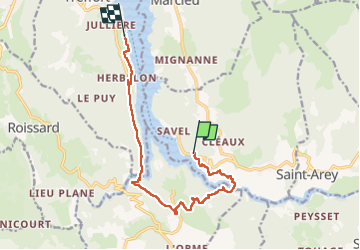
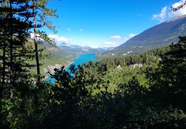
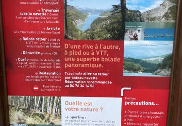
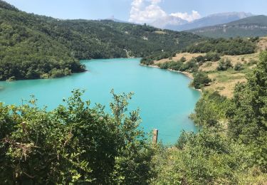
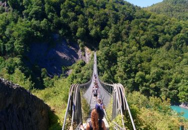
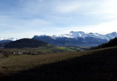
Ruta Senderismo de 11,9 km a descubrir en Auvergne-Rhône-Alpes, Isère, Mayres-Savel. Esta ruta ha sido propuesta por choubaka77.
Descripción
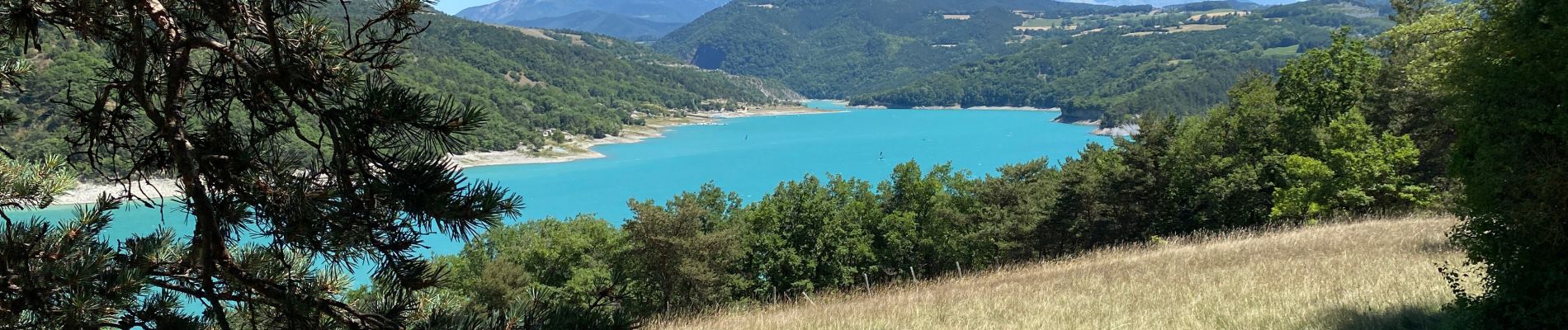
Circuit très agréable avec deux passages en mode frissons !!!! Circuit plus facile en sens inverse 😉
Retour via une traversée en bateau pour finir en mode très relax
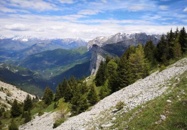
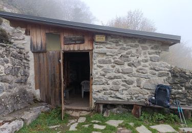
Localización
País:
France
Región :
Auvergne-Rhône-Alpes
Departamento/provincia :
Isère
Municipio :
Mayres-Savel
Localidad:
Unknown
Salida:(Dec)
Salida:(UTM)
712853 ; 4972860 (31T) N.
Comentarios
Excursiones cerca
![Excursión Senderismo Mayres-Savel - Passerelles Du Drac Et de L'Ebron - Photo](https://media.geolcdn.com/t/375/260/f4846bf3-414e-4c51-a6cb-c2da9b823649.jpg&format=jpg&maxdim=2)
![Senderismo Senderismo](https://static1.geolcdn.com/sitytour/trail-icons/101.png)
Passerelles Du Drac Et de L'Ebron
Senderismo
Fácil
Mayres-Savel,
Auvergne-Rhône-Alpes,
Isère,
France
![](/images/other/stat-length.png)
12,2 km | 18,4 km-effort
3h 13min
![](https://static1.geolcdn.com/siteimages/upload/files/16400158638029165_repeat_loop_refresh_sync_direction_icon.png)
No
![Excursión Caballo Roissard - Trieves - Devoluy - Photo](https://media.geolcdn.com/t/375/260/532091fd-ff63-40b6-9790-4b260fef3e51.jpg&format=jpg&maxdim=2)
![Caballo Caballo](https://static1.geolcdn.com/sitytour/trail-icons/300.png)
Trieves - Devoluy
Caballo
Difícil
Roissard,
Auvergne-Rhône-Alpes,
Isère,
France
![](/images/other/stat-length.png)
131 km | 200 km-effort
Desconocido
![](https://static1.geolcdn.com/siteimages/upload/files/16400158638029165_repeat_loop_refresh_sync_direction_icon.png)
Sí
![Excursión Senderismo Mayres-Savel - Passerelles Hymalayene Mayres + 250 - Photo](https://media.geolcdn.com/t/375/260/e79ec6b2-c62a-43e0-95ca-91baa034bf5d.jpg&format=jpg&maxdim=2)
![Senderismo Senderismo](https://static1.geolcdn.com/sitytour/trail-icons/101.png)
Passerelles Hymalayene Mayres + 250
Senderismo
Medio
Mayres-Savel,
Auvergne-Rhône-Alpes,
Isère,
France
![](/images/other/stat-length.png)
4,9 km | 8,2 km-effort
1h 59min
![](https://static1.geolcdn.com/siteimages/upload/files/16400158638029165_repeat_loop_refresh_sync_direction_icon.png)
Sí
![Excursión Senderismo Susville - Susville les Merlins boucle par le col du Sénépiy - Photo](https://media.geolcdn.com/t/375/260/e34bcbf0-51cf-49b5-a532-234a88d268fc.jpg&format=jpg&maxdim=2)
![Senderismo Senderismo](https://static1.geolcdn.com/sitytour/trail-icons/101.png)
Susville les Merlins boucle par le col du Sénépiy
Senderismo
Medio
Susville,
Auvergne-Rhône-Alpes,
Isère,
France
![](/images/other/stat-length.png)
10,1 km | 16,3 km-effort
3h 30min
![](https://static1.geolcdn.com/siteimages/upload/files/16400158638029165_repeat_loop_refresh_sync_direction_icon.png)
Sí
![Excursión Senderismo Treffort - ISERE: MONTEYNARD PASSERELLES HIMALAYENNES - Photo](https://media.geolcdn.com/t/375/260/76721c9b-6b33-4db9-86bf-ba7e9a8d140f.jpg&format=jpg&maxdim=2)
![Senderismo Senderismo](https://static1.geolcdn.com/sitytour/trail-icons/101.png)
ISERE: MONTEYNARD PASSERELLES HIMALAYENNES
Senderismo
Medio
Treffort,
Auvergne-Rhône-Alpes,
Isère,
France
![](/images/other/stat-length.png)
16,1 km | 22 km-effort
3h 52min
![](https://static1.geolcdn.com/siteimages/upload/files/16400158638029165_repeat_loop_refresh_sync_direction_icon.png)
Sí
![Excursión Senderismo Treffort - Valgo2 - J3. : les passerelles de Monteynard - Photo](https://media.geolcdn.com/t/375/260/80ded9ce-faa3-4fe9-b5ad-3607bd08278e.jpg&format=jpg&maxdim=2)
![Senderismo Senderismo](https://static1.geolcdn.com/sitytour/trail-icons/101.png)
Valgo2 - J3. : les passerelles de Monteynard
Senderismo
Fácil
Treffort,
Auvergne-Rhône-Alpes,
Isère,
France
![](/images/other/stat-length.png)
12,4 km | 18,6 km-effort
2h 42min
![](https://static1.geolcdn.com/siteimages/upload/files/16400158638029165_repeat_loop_refresh_sync_direction_icon.png)
No
![Excursión Senderismo Treffort - Passerelle Drac - Photo](https://media.geolcdn.com/t/375/260/feb433be-0155-46e7-819a-3b1bb0447bc5.jpg&format=jpg&maxdim=2)
![Senderismo Senderismo](https://static1.geolcdn.com/sitytour/trail-icons/101.png)
Passerelle Drac
Senderismo
Muy difícil
Treffort,
Auvergne-Rhône-Alpes,
Isère,
France
![](/images/other/stat-length.png)
11,9 km | 18,2 km-effort
4h 3min
![](https://static1.geolcdn.com/siteimages/upload/files/16400158638029165_repeat_loop_refresh_sync_direction_icon.png)
No
![Excursión Senderismo Treffort - Les deux passerelles Drac et Ebron - Photo](https://media.geolcdn.com/t/375/260/3778f66d-36c2-41c5-9e06-64b09fbd2374.jpg&format=jpg&maxdim=2)
![Senderismo Senderismo](https://static1.geolcdn.com/sitytour/trail-icons/101.png)
Les deux passerelles Drac et Ebron
Senderismo
Medio
Treffort,
Auvergne-Rhône-Alpes,
Isère,
France
![](/images/other/stat-length.png)
15,8 km | 25 km-effort
3h 23min
![](https://static1.geolcdn.com/siteimages/upload/files/16400158638029165_repeat_loop_refresh_sync_direction_icon.png)
Sí
![Excursión Senderismo Lavars - Serre de la Fayolle - Photo](https://media.geolcdn.com/t/375/260/95bdaed1-9210-48db-8488-a02aafbf5b89.jpg&format=jpg&maxdim=2)
![Senderismo Senderismo](https://static1.geolcdn.com/sitytour/trail-icons/101.png)
Serre de la Fayolle
Senderismo
Medio
Lavars,
Auvergne-Rhône-Alpes,
Isère,
France
![](/images/other/stat-length.png)
13,3 km | 19,9 km-effort
5h 53min
![](https://static1.geolcdn.com/siteimages/upload/files/16400158638029165_repeat_loop_refresh_sync_direction_icon.png)
Sí