![](/images/other/stat-length.png)
![Excursión Senderismo Erquy - LE CAP D'ERQUY DEPUIS LE CAMPING LA VALLEE - Photo](https://media.geolcdn.com/t/1900/400/844bcf38-4939-4501-9740-44824bba3a6f.jpg&format=pjpeg&maxdim=2)
LE CAP D'ERQUY DEPUIS LE CAMPING LA VALLEE
walrou63
Usuario
![Longitud](/images/other/stat-length.png)
Longitud
15,8 km
![Altitud máxima](https://static1.geolcdn.com/siteimages/upload/files/1508320355ic_sort_altitude_max_24dp.png)
Altitud máxima
66 m
![Desnivel positivo](https://static1.geolcdn.com/siteimages/upload/files/1508320355ic_sort_den_pos_24dp.png)
Desnivel positivo
303 m
![Km-Effort](/images/other/stat-length.png)
Km-Effort
19,9 km
![Altitud mínima](https://static1.geolcdn.com/siteimages/upload/files/1508320355ic_sort_altitude_min_24dp.png)
Altitud mínima
0 m
![Desnivel negativo](https://static1.geolcdn.com/siteimages/upload/files/1508320355ic_sort_den_neg_24dp.png)
Desnivel negativo
302 m
![Boucle](https://static1.geolcdn.com/siteimages/upload/files/16400158638029165_repeat_loop_refresh_sync_direction_icon.png)
Boucle
Sí
Fecha de creación :
2022-07-07 11:31:47.928
Última modificación :
2022-07-07 16:36:10.872
![Senderismo](https://static1.geolcdn.com/sitytour/trail-icons/101.png)
3h43
Dificultad : Muy difícil
![Escanee este código QR para abrir la excursión en la aplicación SityTrail](https://capi.geolives.com/qq0zvz2zws4bq2lad0pu/sitytour/trails/3308014/qr.png?size=200)
Aplicación GPS de excursión GRATIS
A propósito
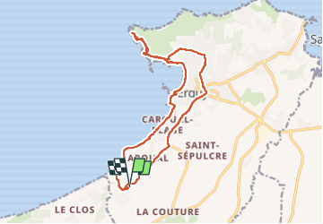
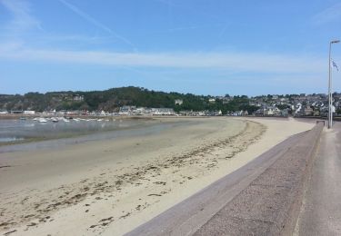
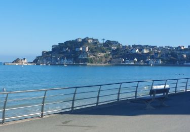
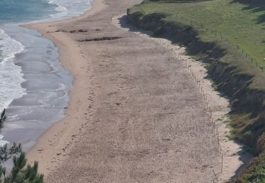
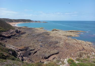
Ruta Senderismo de 15,8 km a descubrir en Bretaña, Côtes-d'Armor, Erquy. Esta ruta ha sido propuesta por walrou63.
Descripción
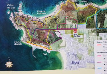
Aller jusqu'au Cap par le sentier côtier et retour par les lacs bleus, le sentier des carries puis le viaduc de Caroual
Localización
País:
France
Región :
Bretaña
Departamento/provincia :
Côtes-d'Armor
Municipio :
Erquy
Localidad:
Unknown
Salida:(Dec)
Salida:(UTM)
537722 ; 5383656 (30U) N.
Comentarios
Excursiones cerca
![Excursión Senderismo Erquy - Tour du Cap d''Erquy - Photo](https://media.geolcdn.com/t/375/260/6485fa67-2fed-4d4f-8749-6eb0f328b98b.jpg&format=jpg&maxdim=2)
![Senderismo Senderismo](https://static1.geolcdn.com/sitytour/trail-icons/101.png)
Tour du Cap d''Erquy
Senderismo
Medio
(1)
Erquy,
Bretaña,
Côtes-d'Armor,
France
![](/images/other/stat-length.png)
19,4 km | 24 km-effort
5h 24min
![](https://static1.geolcdn.com/siteimages/upload/files/16400158638029165_repeat_loop_refresh_sync_direction_icon.png)
Sí
![Excursión Senderismo Pléneuf-Val-André - SityTrail - GR 34 Pléneuf Val andré -- Hillion - Photo](https://media.geolcdn.com/t/375/260/a7664a50-bf36-435d-8dd9-5d811f168a14.jpg&format=jpg&maxdim=2)
![Senderismo Senderismo](https://static1.geolcdn.com/sitytour/trail-icons/101.png)
SityTrail - GR 34 Pléneuf Val andré -- Hillion
Senderismo
Muy difícil
Pléneuf-Val-André,
Bretaña,
Côtes-d'Armor,
France
![](/images/other/stat-length.png)
24 km | 30 km-effort
6h 54min
![](https://static1.geolcdn.com/siteimages/upload/files/16400158638029165_repeat_loop_refresh_sync_direction_icon.png)
No
![Excursión Senderismo Erquy - Erquy - 3.1km 50m 1h00 - 2017 06 22 - Photo](https://media.geolcdn.com/t/375/260/f1762648-9675-40fc-8b6f-f9ba25589aab.jpg&format=jpg&maxdim=2)
![Senderismo Senderismo](https://static1.geolcdn.com/sitytour/trail-icons/101.png)
Erquy - 3.1km 50m 1h00 - 2017 06 22
Senderismo
Muy fácil
Erquy,
Bretaña,
Côtes-d'Armor,
France
![](/images/other/stat-length.png)
3,1 km | 3,6 km-effort
45min
![](https://static1.geolcdn.com/siteimages/upload/files/16400158638029165_repeat_loop_refresh_sync_direction_icon.png)
Sí
![Excursión Senderismo Pléneuf-Val-André - GR_34_CA_14_Pleneuf-Val-Andre_Lamballe_20230820 - Photo](https://media.geolcdn.com/t/375/260/dc9169ae-5d20-486b-b60a-ec7c033f0c7b.jpg&format=jpg&maxdim=2)
![Senderismo Senderismo](https://static1.geolcdn.com/sitytour/trail-icons/101.png)
GR_34_CA_14_Pleneuf-Val-Andre_Lamballe_20230820
Senderismo
Medio
Pléneuf-Val-André,
Bretaña,
Côtes-d'Armor,
France
![](/images/other/stat-length.png)
14 km | 17,9 km-effort
3h 33min
![](https://static1.geolcdn.com/siteimages/upload/files/16400158638029165_repeat_loop_refresh_sync_direction_icon.png)
No
![Excursión Senderismo Erquy - GR_34_BG_13_Erquy_Pleneuf-Val-Andre_20230819 - Photo](https://media.geolcdn.com/t/375/260/89ae597d-a66d-43f8-b940-7aa601d4c3de.jpg&format=jpg&maxdim=2)
![Senderismo Senderismo](https://static1.geolcdn.com/sitytour/trail-icons/101.png)
GR_34_BG_13_Erquy_Pleneuf-Val-Andre_20230819
Senderismo
Medio
Erquy,
Bretaña,
Côtes-d'Armor,
France
![](/images/other/stat-length.png)
17,2 km | 22 km-effort
4h 36min
![](https://static1.geolcdn.com/siteimages/upload/files/16400158638029165_repeat_loop_refresh_sync_direction_icon.png)
No
![Excursión Senderismo Erquy - Cap d'Erquy 3.7.23 - Photo](https://media.geolcdn.com/t/375/260/16ce8f05-b6ce-4867-9ff5-66cfc2a896f6.jpg&format=jpg&maxdim=2)
![Senderismo Senderismo](https://static1.geolcdn.com/sitytour/trail-icons/101.png)
Cap d'Erquy 3.7.23
Senderismo
Fácil
Erquy,
Bretaña,
Côtes-d'Armor,
France
![](/images/other/stat-length.png)
7,3 km | 9,2 km-effort
2h 20min
![](https://static1.geolcdn.com/siteimages/upload/files/16400158638029165_repeat_loop_refresh_sync_direction_icon.png)
Sí
![Excursión Senderismo Erquy - CAP D'ERQUY - Photo](https://media.geolcdn.com/t/375/260/447534fd-609d-4795-8f40-8260c0c6a6be.jpg&format=jpg&maxdim=2)
![Senderismo Senderismo](https://static1.geolcdn.com/sitytour/trail-icons/101.png)
CAP D'ERQUY
Senderismo
Medio
Erquy,
Bretaña,
Côtes-d'Armor,
France
![](/images/other/stat-length.png)
4,5 km | 5,2 km-effort
2h 0min
![](https://static1.geolcdn.com/siteimages/upload/files/16400158638029165_repeat_loop_refresh_sync_direction_icon.png)
Sí
![Excursión Senderismo Erquy - Erquil - Photo](https://media.geolcdn.com/t/375/260/3500ee67-cf40-48aa-824a-8cc36a0b4ccc.jpg&format=jpg&maxdim=2)
![Senderismo Senderismo](https://static1.geolcdn.com/sitytour/trail-icons/101.png)
Erquil
Senderismo
Muy fácil
Erquy,
Bretaña,
Côtes-d'Armor,
France
![](/images/other/stat-length.png)
9,2 km | 11,6 km-effort
2h 40min
![](https://static1.geolcdn.com/siteimages/upload/files/16400158638029165_repeat_loop_refresh_sync_direction_icon.png)
Sí
![Excursión Senderismo Erquy - 201908 promenade Erquy - Photo](https://media.geolcdn.com/t/375/260/7c3acd72-1f5c-4646-969c-4dac89fe4c23.jpg&format=jpg&maxdim=2)
![Senderismo Senderismo](https://static1.geolcdn.com/sitytour/trail-icons/101.png)
201908 promenade Erquy
Senderismo
Muy fácil
Erquy,
Bretaña,
Côtes-d'Armor,
France
![](/images/other/stat-length.png)
6,3 km | 8,2 km-effort
3h 39min
![](https://static1.geolcdn.com/siteimages/upload/files/16400158638029165_repeat_loop_refresh_sync_direction_icon.png)
No