![](/images/other/stat-length.png)
![Excursión Senderismo Névache - balcon de nevache - Photo](https://media.geolcdn.com/t/1900/400/ext.pjpeg?maxdim=2&url=https%3A%2F%2Fmedia.geolcdn.com%2Ff%2F7248486e-6fcf-4dfa-a2dc-0a9a56ffc069.jpg)
balcon de nevache
RayFab
Usuario
![Longitud](/images/other/stat-length.png)
Longitud
8,9 km
![Altitud máxima](https://static1.geolcdn.com/siteimages/upload/files/1508320355ic_sort_altitude_max_24dp.png)
Altitud máxima
1855 m
![Desnivel positivo](https://static1.geolcdn.com/siteimages/upload/files/1508320355ic_sort_den_pos_24dp.png)
Desnivel positivo
317 m
![Km-Effort](/images/other/stat-length.png)
Km-Effort
13,1 km
![Altitud mínima](https://static1.geolcdn.com/siteimages/upload/files/1508320355ic_sort_altitude_min_24dp.png)
Altitud mínima
1585 m
![Desnivel negativo](https://static1.geolcdn.com/siteimages/upload/files/1508320355ic_sort_den_neg_24dp.png)
Desnivel negativo
318 m
![Boucle](https://static1.geolcdn.com/siteimages/upload/files/16400158638029165_repeat_loop_refresh_sync_direction_icon.png)
Boucle
Sí
Fecha de creación :
2022-06-21 06:33:43.612
Última modificación :
2022-06-22 05:08:48.336
![Senderismo](https://static1.geolcdn.com/sitytour/trail-icons/101.png)
3h02
Dificultad : Fácil
![Escanee este código QR para abrir la excursión en la aplicación SityTrail](https://capi.geolives.com/qq0zvz2zws4bq2lad0pu/sitytour/trails/3289791/qr.png?size=200)
Aplicación GPS de excursión GRATIS
A propósito
Ruta Senderismo de 8,9 km a descubrir en Provenza-Alpes-Costa Azul, Altos Alpes, Névache. Esta ruta ha sido propuesta por RayFab.
Descripción
Magnifique randonnée sur les hauteurs de Névache pour finir par une descente au milieu des bois. Balade facile
Localización
País:
France
Región :
Provenza-Alpes-Costa Azul
Departamento/provincia :
Altos Alpes
Municipio :
Névache
Localidad:
Unknown
Salida:(Dec)
Salida:(UTM)
311782 ; 4987774 (32T) N.
Comentarios
Excursiones cerca
![Excursión Senderismo Névache - Via Alpina - R127: Névache > Le Monêtier-les-Bains - Photo](https://media.geolcdn.com/t/375/260/ext.jpg?maxdim=2&url=https%3A%2F%2Fservices.sitytrail.com%2FGeolivesWS%2FDownloadMedia.ashx%3FTrailID%3D109685%26Media%3D4354_1.jpg)
![Senderismo Senderismo](https://static1.geolcdn.com/sitytour/trail-icons/101.png)
Via Alpina - R127: Névache > Le Monêtier-les-Bains
Senderismo
Difícil
(1)
Névache,
Provenza-Alpes-Costa Azul,
Altos Alpes,
France
![](/images/other/stat-length.png)
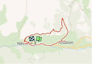
15,5 km | 28 km-effort
5h 0min
![](https://static1.geolcdn.com/siteimages/upload/files/16400158638029165_repeat_loop_refresh_sync_direction_icon.png)
No
![Excursión Senderismo Névache - LA CLAREE: balcon de la claree - Photo](https://media.geolcdn.com/t/375/260/ext.jpg?maxdim=2&url=https%3A%2F%2Fmedia.geolcdn.com%2Ff%2Fd371ed49-40d8-478d-9508-5cf2ffc79f21.jpg)
![Senderismo Senderismo](https://static1.geolcdn.com/sitytour/trail-icons/101.png)
LA CLAREE: balcon de la claree
Senderismo
Medio
Névache,
Provenza-Alpes-Costa Azul,
Altos Alpes,
France
![](/images/other/stat-length.png)
14,2 km | 23 km-effort
4h 7min
![](https://static1.geolcdn.com/siteimages/upload/files/16400158638029165_repeat_loop_refresh_sync_direction_icon.png)
Sí
![Excursión Senderismo Névache - Col des Thures - Lac Chavillon - Photo](https://media.geolcdn.com/t/375/260/ext.jpg?maxdim=2&url=https%3A%2F%2Fmedia.geolcdn.com%2Ff%2Fda16f78b-b53f-4954-8942-a2c84ed5c24c.JPG)
![Senderismo Senderismo](https://static1.geolcdn.com/sitytour/trail-icons/101.png)
Col des Thures - Lac Chavillon
Senderismo
Medio
Névache,
Provenza-Alpes-Costa Azul,
Altos Alpes,
France
![](/images/other/stat-length.png)
5,3 km | 11,1 km-effort
2h 31min
![](https://static1.geolcdn.com/siteimages/upload/files/16400158638029165_repeat_loop_refresh_sync_direction_icon.png)
No
![Excursión Senderismo Névache - Les lacs de Chavillon et Beletty par le col des Thures - Photo](https://media.geolcdn.com/t/375/260/ext.jpg?maxdim=2&url=https%3A%2F%2Fmedia.geolcdn.com%2Ff%2Fa2e93ca1-aa49-4d24-b686-66f2fbfdfde2.jpg)
![Senderismo Senderismo](https://static1.geolcdn.com/sitytour/trail-icons/101.png)
Les lacs de Chavillon et Beletty par le col des Thures
Senderismo
Medio
Névache,
Provenza-Alpes-Costa Azul,
Altos Alpes,
France
![](/images/other/stat-length.png)
12,1 km | 21 km-effort
6h 5min
![](https://static1.geolcdn.com/siteimages/upload/files/16400158638029165_repeat_loop_refresh_sync_direction_icon.png)
No
![Excursión Senderismo Névache - J2 2023 - Névache : Le Grand Area - Photo](https://media.geolcdn.com/t/375/260/ext.jpg?maxdim=2&url=https%3A%2F%2Fmedia.geolcdn.com%2Ff%2F14fedbdb-5e43-4b19-bd88-57cedae1e8a0.jpg)
![Senderismo Senderismo](https://static1.geolcdn.com/sitytour/trail-icons/101.png)
J2 2023 - Névache : Le Grand Area
Senderismo
Muy difícil
Névache,
Provenza-Alpes-Costa Azul,
Altos Alpes,
France
![](/images/other/stat-length.png)
23 km | 43 km-effort
6h 58min
![](https://static1.geolcdn.com/siteimages/upload/files/16400158638029165_repeat_loop_refresh_sync_direction_icon.png)
Sí
![Excursión Bici de montaña Névache - nevache VTT 47 échelle vallée étroite - Photo](https://media.geolcdn.com/t/375/260/ext.jpg?maxdim=2&url=https%3A%2F%2Fmedia.geolcdn.com%2Ff%2F00fa735a-f125-4109-874a-4f2705dfc752.jpg)
![Bici de montaña Bici de montaña](https://static1.geolcdn.com/sitytour/trail-icons/202.png)
nevache VTT 47 échelle vallée étroite
Bici de montaña
Difícil
Névache,
Provenza-Alpes-Costa Azul,
Altos Alpes,
France
![](/images/other/stat-length.png)
25 km | 38 km-effort
2h 58min
![](https://static1.geolcdn.com/siteimages/upload/files/16400158638029165_repeat_loop_refresh_sync_direction_icon.png)
Sí
![Excursión Senderismo Névache - Nevache2 - Photo](https://media.geolcdn.com/t/375/260/ext.jpg?maxdim=2&url=https%3A%2F%2Fmedia.geolcdn.com%2Ff%2F881ade8c-516a-4b31-aa80-760ac5c06afd.jpg)
![Senderismo Senderismo](https://static1.geolcdn.com/sitytour/trail-icons/101.png)
Nevache2
Senderismo
Medio
Névache,
Provenza-Alpes-Costa Azul,
Altos Alpes,
France
![](/images/other/stat-length.png)
13,1 km | 25 km-effort
8h 53min
![](https://static1.geolcdn.com/siteimages/upload/files/16400158638029165_repeat_loop_refresh_sync_direction_icon.png)
Sí
![Excursión Senderismo Névache - Nevache 1 - Photo](https://media.geolcdn.com/t/375/260/ext.jpg?maxdim=2&url=https%3A%2F%2Fmedia.geolcdn.com%2Ff%2F05a3447e-5e70-465b-815b-21b9527d32e4.jpg)
![Senderismo Senderismo](https://static1.geolcdn.com/sitytour/trail-icons/101.png)
Nevache 1
Senderismo
Medio
Névache,
Provenza-Alpes-Costa Azul,
Altos Alpes,
France
![](/images/other/stat-length.png)
13,5 km | 23 km-effort
6h 49min
![](https://static1.geolcdn.com/siteimages/upload/files/16400158638029165_repeat_loop_refresh_sync_direction_icon.png)
Sí
![Excursión Esquí de fondo Névache - roche gauthier couloir nord - Photo](https://media.geolcdn.com/t/375/260/ext.jpg?maxdim=2&url=https%3A%2F%2Fmedia.geolcdn.com%2Ff%2F4a39c1aa-0043-49c4-bb96-0f890209a6cd.jpg)
![Esquí de fondo Esquí de fondo](https://static1.geolcdn.com/sitytour/trail-icons/503.png)
roche gauthier couloir nord
Esquí de fondo
Difícil
Névache,
Provenza-Alpes-Costa Azul,
Altos Alpes,
France
![](/images/other/stat-length.png)
12,5 km | 27 km-effort
3h 6min
![](https://static1.geolcdn.com/siteimages/upload/files/16400158638029165_repeat_loop_refresh_sync_direction_icon.png)
Sí
jolie balade