![](/images/other/stat-length.png)
![Excursión Senderismo Modane - les chalets d'Arplane depuis val fréjus - Photo](https://media.geolcdn.com/t/1900/400/ext.pjpeg?maxdim=2&url=https%3A%2F%2Fstatic1.geolcdn.com%2Fsiteimages%2Fupload%2Ffiles%2F1553511878bg_sport_marche.png)
les chalets d'Arplane depuis val fréjus
hugo26
Usuario
![Longitud](/images/other/stat-length.png)
Longitud
11,1 km
![Altitud máxima](https://static1.geolcdn.com/siteimages/upload/files/1508320355ic_sort_altitude_max_24dp.png)
Altitud máxima
2318 m
![Desnivel positivo](https://static1.geolcdn.com/siteimages/upload/files/1508320355ic_sort_den_pos_24dp.png)
Desnivel positivo
827 m
![Km-Effort](/images/other/stat-length.png)
Km-Effort
22 km
![Altitud mínima](https://static1.geolcdn.com/siteimages/upload/files/1508320355ic_sort_altitude_min_24dp.png)
Altitud mínima
1532 m
![Desnivel negativo](https://static1.geolcdn.com/siteimages/upload/files/1508320355ic_sort_den_neg_24dp.png)
Desnivel negativo
828 m
![Boucle](https://static1.geolcdn.com/siteimages/upload/files/16400158638029165_repeat_loop_refresh_sync_direction_icon.png)
Boucle
Sí
Fecha de creación :
2022-06-21 08:12:52.379
Última modificación :
2022-06-21 08:15:39.685
![Senderismo](https://static1.geolcdn.com/sitytour/trail-icons/101.png)
5h02
Dificultad : Muy difícil
![Escanee este código QR para abrir la excursión en la aplicación SityTrail](https://capi.geolives.com/qq0zvz2zws4bq2lad0pu/sitytour/trails/3289639/qr.png?size=200)
Aplicación GPS de excursión GRATIS
A propósito
Ruta Senderismo de 11,1 km a descubrir en Auvergne-Rhône-Alpes, Saboya, Modane. Esta ruta ha sido propuesta por hugo26.
Descripción
Belle rando au départ de val Fréjus pour les chalets d'arplane et retour par la tura.
Localización
País:
France
Región :
Auvergne-Rhône-Alpes
Departamento/provincia :
Saboya
Municipio :
Modane
Localidad:
Unknown
Salida:(Dec)
Salida:(UTM)
315403 ; 5004708 (32T) N.
Comentarios
Excursiones cerca
![Excursión Senderismo Modane - Valfrejus refuge du Mont Thabor - Photo](https://media.geolcdn.com/t/375/260/2ea31b81-693a-4382-810b-6d006cdc47b1.jpg&format=jpg&maxdim=2)
![Senderismo Senderismo](https://static1.geolcdn.com/sitytour/trail-icons/101.png)
Valfrejus refuge du Mont Thabor
Senderismo
Medio
(1)
Modane,
Auvergne-Rhône-Alpes,
Saboya,
France
![](/images/other/stat-length.png)
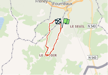
19,4 km | 33 km-effort
6h 32min
![](https://static1.geolcdn.com/siteimages/upload/files/16400158638029165_repeat_loop_refresh_sync_direction_icon.png)
Sí
![Excursión Esquí de fondo Modane - Le Grand Argentier - Photo](https://media.geolcdn.com/t/375/260/e21d4ca1-38c7-443d-8026-c36fbc8a0292.jpg&format=jpg&maxdim=2)
![Esquí de fondo Esquí de fondo](https://static1.geolcdn.com/sitytour/trail-icons/503.png)
Le Grand Argentier
Esquí de fondo
Medio
Modane,
Auvergne-Rhône-Alpes,
Saboya,
France
![](/images/other/stat-length.png)
18,6 km | 37 km-effort
5h 45min
![](https://static1.geolcdn.com/siteimages/upload/files/16400158638029165_repeat_loop_refresh_sync_direction_icon.png)
Sí
![Excursión Esquí de fondo Modane - pointe des sarrasins - Photo](https://media.geolcdn.com/t/375/260/11a876bf-96a7-4155-9789-408cc9cbafaf.jpg&format=jpg&maxdim=2)
![Esquí de fondo Esquí de fondo](https://static1.geolcdn.com/sitytour/trail-icons/503.png)
pointe des sarrasins
Esquí de fondo
Medio
Modane,
Auvergne-Rhône-Alpes,
Saboya,
France
![](/images/other/stat-length.png)
17 km | 35 km-effort
5h 17min
![](https://static1.geolcdn.com/siteimages/upload/files/16400158638029165_repeat_loop_refresh_sync_direction_icon.png)
Sí
![Excursión Esquí de fondo Villarodin-Bourget - passage de la belle Plinier Nord - Photo](https://media.geolcdn.com/t/375/260/24fce6f9-d37e-4224-8f2c-4b95f0071df0.jpg&format=jpg&maxdim=2)
![Esquí de fondo Esquí de fondo](https://static1.geolcdn.com/sitytour/trail-icons/503.png)
passage de la belle Plinier Nord
Esquí de fondo
Medio
Villarodin-Bourget,
Auvergne-Rhône-Alpes,
Saboya,
France
![](/images/other/stat-length.png)
16 km | 37 km-effort
6h 1min
![](https://static1.geolcdn.com/siteimages/upload/files/16400158638029165_repeat_loop_refresh_sync_direction_icon.png)
Sí
![Excursión Esquí de fondo Saint-André - Tête noire en boucle - Photo](https://media.geolcdn.com/t/375/260/0bb3542f-e5da-45e0-a1b0-86c9b0c52fb3.jpg&format=jpg&maxdim=2)
![Esquí de fondo Esquí de fondo](https://static1.geolcdn.com/sitytour/trail-icons/503.png)
Tête noire en boucle
Esquí de fondo
Medio
Saint-André,
Auvergne-Rhône-Alpes,
Saboya,
France
![](/images/other/stat-length.png)
26 km | 51 km-effort
8h 8min
![](https://static1.geolcdn.com/siteimages/upload/files/16400158638029165_repeat_loop_refresh_sync_direction_icon.png)
Sí
![Excursión Raquetas de nieve Saint-André - l Orgere - Photo](https://media.geolcdn.com/t/375/260/68f383ec-1a93-4bdd-ac56-2814b85cf93a.jpg&format=jpg&maxdim=2)
![Raquetas de nieve Raquetas de nieve](https://static1.geolcdn.com/sitytour/trail-icons/504.png)
l Orgere
Raquetas de nieve
Fácil
Saint-André,
Auvergne-Rhône-Alpes,
Saboya,
France
![](/images/other/stat-length.png)
11,7 km | 18,8 km-effort
5h 14min
![](https://static1.geolcdn.com/siteimages/upload/files/16400158638029165_repeat_loop_refresh_sync_direction_icon.png)
Sí
![Excursión Senderismo Modane - mont Thabor - Photo](https://media.geolcdn.com/t/375/260/ext.jpg?maxdim=2&url=https%3A%2F%2Fstatic1.geolcdn.com%2Fsiteimages%2Fupload%2Ffiles%2F1553511878bg_sport_marche.png)
![Senderismo Senderismo](https://static1.geolcdn.com/sitytour/trail-icons/101.png)
mont Thabor
Senderismo
Difícil
(1)
Modane,
Auvergne-Rhône-Alpes,
Saboya,
France
![](/images/other/stat-length.png)
14,3 km | 29 km-effort
6h 24min
![](https://static1.geolcdn.com/siteimages/upload/files/16400158638029165_repeat_loop_refresh_sync_direction_icon.png)
No
![Excursión Senderismo Villarodin-Bourget - La Norma / Télécabine Melezet / Valfréjus - Photo](https://media.geolcdn.com/t/375/260/588a4be4-ac90-41f5-b3fb-9c859be949e5.jpg&format=jpg&maxdim=2)
![Senderismo Senderismo](https://static1.geolcdn.com/sitytour/trail-icons/101.png)
La Norma / Télécabine Melezet / Valfréjus
Senderismo
Difícil
Villarodin-Bourget,
Auvergne-Rhône-Alpes,
Saboya,
France
![](/images/other/stat-length.png)
9,8 km | 22 km-effort
3h 56min
![](https://static1.geolcdn.com/siteimages/upload/files/16400158638029165_repeat_loop_refresh_sync_direction_icon.png)
No
![Excursión Senderismo Modane - Télécabine Arrondaz Punta Bagna Lavoir Valfréjus - Photo](https://media.geolcdn.com/t/375/260/357497bc-6554-4d63-bbed-5431d02fde83.jpg&format=jpg&maxdim=2)
![Senderismo Senderismo](https://static1.geolcdn.com/sitytour/trail-icons/101.png)
Télécabine Arrondaz Punta Bagna Lavoir Valfréjus
Senderismo
Medio
Modane,
Auvergne-Rhône-Alpes,
Saboya,
France
![](/images/other/stat-length.png)
17,5 km | 27 km-effort
3h 47min
![](https://static1.geolcdn.com/siteimages/upload/files/16400158638029165_repeat_loop_refresh_sync_direction_icon.png)
No