![](/images/other/stat-length.png)
![Excursión Bici de montaña Sainte-Marie-de-Ré - 17-vtt-ste-marie-rivedoux-la-flotte-st-martin-39km - Photo](https://media.geolcdn.com/t/1900/400/ext.pjpeg?maxdim=2&url=https%3A%2F%2Fmedia.geolcdn.com%2Ff%2F69622bb9-f3d5-4af1-b588-98519501a98e.jpg)
17-vtt-ste-marie-rivedoux-la-flotte-st-martin-39km
SyMA
Usuario
![Longitud](/images/other/stat-length.png)
Longitud
39 km
![Altitud máxima](https://static1.geolcdn.com/siteimages/upload/files/1508320355ic_sort_altitude_max_24dp.png)
Altitud máxima
17 m
![Desnivel positivo](https://static1.geolcdn.com/siteimages/upload/files/1508320355ic_sort_den_pos_24dp.png)
Desnivel positivo
209 m
![Km-Effort](/images/other/stat-length.png)
Km-Effort
42 km
![Altitud mínima](https://static1.geolcdn.com/siteimages/upload/files/1508320355ic_sort_altitude_min_24dp.png)
Altitud mínima
-1 m
![Desnivel negativo](https://static1.geolcdn.com/siteimages/upload/files/1508320355ic_sort_den_neg_24dp.png)
Desnivel negativo
210 m
![Boucle](https://static1.geolcdn.com/siteimages/upload/files/16400158638029165_repeat_loop_refresh_sync_direction_icon.png)
Boucle
Sí
Fecha de creación :
2022-06-19 08:33:54.608
Última modificación :
2022-06-27 06:33:43.298
![Bici de montaña](https://static1.geolcdn.com/sitytour/trail-icons/202.png)
4h50
Dificultad : Medio
![Escanee este código QR para abrir la excursión en la aplicación SityTrail](https://capi.geolives.com/qq0zvz2zws4bq2lad0pu/sitytour/trails/3287835/qr.png?size=200)
Aplicación GPS de excursión GRATIS
A propósito
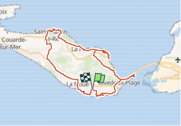
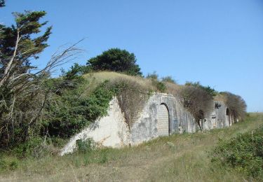
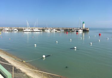
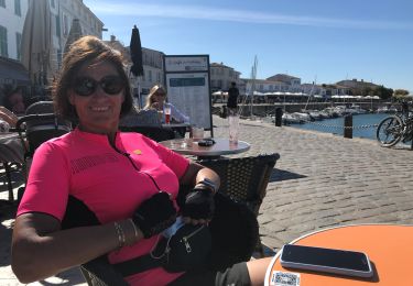
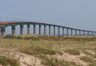
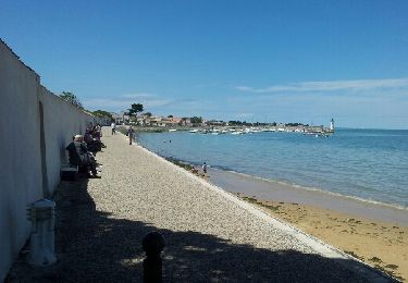
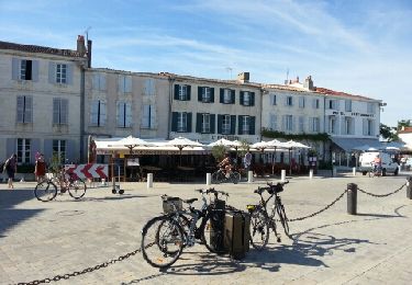
Ruta Bici de montaña de 39 km a descubrir en Nueva Aquitania, Charente-Maritime, Sainte-Marie-de-Ré. Esta ruta ha sido propuesta por SyMA.
Descripción
Départ et arrivée Parking Mairie de Ste Marie de Ré
passage par Rivedoux / La Flotte/ St Martin /La Noue
Aucune difficulté et peu de dénivelé.
Localización
País:
France
Región :
Nueva Aquitania
Departamento/provincia :
Charente-Maritime
Municipio :
Sainte-Marie-de-Ré
Localidad:
Unknown
Salida:(Dec)
Salida:(UTM)
630357 ; 5112172 (30T) N.
Comentarios
Excursiones cerca
![Excursión Senderismo Le Bois-Plage-en-Ré - Promenons-nous dans le bois - Le Bois Plage en Ré - Photo](https://media.geolcdn.com/t/375/260/ext.jpg?maxdim=2&url=https%3A%2F%2Fservices.sitytrail.com%2FGeolivesWS%2FDownloadMedia.ashx%3FTrailID%3D191605%26Media%3D15244_6.jpg)
![Senderismo Senderismo](https://static1.geolcdn.com/sitytour/trail-icons/101.png)
Promenons-nous dans le bois - Le Bois Plage en Ré
Senderismo
Medio
(3)
Le Bois-Plage-en-Ré,
Nueva Aquitania,
Charente-Maritime,
France
![](/images/other/stat-length.png)
10,3 km | 11,3 km-effort
2h 40min
![](https://static1.geolcdn.com/siteimages/upload/files/16400158638029165_repeat_loop_refresh_sync_direction_icon.png)
Sí
![Excursión Senderismo Rivedoux-Plage - Sentier du littoral - Rivedoux-Plage - Photo](https://media.geolcdn.com/t/375/260/ext.jpg?maxdim=2&url=https%3A%2F%2Fservices.sitytrail.com%2FGeolivesWS%2FDownloadMedia.ashx%3FTrailID%3D191591%26Media%3D15221_6.jpg)
![Senderismo Senderismo](https://static1.geolcdn.com/sitytour/trail-icons/101.png)
Sentier du littoral - Rivedoux-Plage
Senderismo
Medio
(1)
Rivedoux-Plage,
Nueva Aquitania,
Charente-Maritime,
France
![](/images/other/stat-length.png)
10,8 km | 11,6 km-effort
2h 30min
![](https://static1.geolcdn.com/siteimages/upload/files/16400158638029165_repeat_loop_refresh_sync_direction_icon.png)
Sí
![Excursión Senderismo Rivedoux-Plage - Les Gros Peux - Rivedoux - Photo](https://media.geolcdn.com/t/375/260/ext.jpg?maxdim=2&url=https%3A%2F%2Fservices.sitytrail.com%2FGeolivesWS%2FDownloadMedia.ashx%3FTrailID%3D191590%26Media%3D15220_6.jpg)
![Senderismo Senderismo](https://static1.geolcdn.com/sitytour/trail-icons/101.png)
Les Gros Peux - Rivedoux
Senderismo
Fácil
(5)
Rivedoux-Plage,
Nueva Aquitania,
Charente-Maritime,
France
![](/images/other/stat-length.png)
6,4 km | 6,8 km-effort
1h 30min
![](https://static1.geolcdn.com/siteimages/upload/files/16400158638029165_repeat_loop_refresh_sync_direction_icon.png)
Sí
![Excursión Senderismo Rivedoux-Plage - Rivedoux plage - Photo](https://media.geolcdn.com/t/375/260/ext.jpg?maxdim=2&url=https%3A%2F%2Fmedia.geolcdn.com%2Ff%2F55b24b39-5c26-4df0-b6d4-863e4a24fee7.jpg)
![Senderismo Senderismo](https://static1.geolcdn.com/sitytour/trail-icons/101.png)
Rivedoux plage
Senderismo
Difícil
Rivedoux-Plage,
Nueva Aquitania,
Charente-Maritime,
France
![](/images/other/stat-length.png)
11,6 km | 12,3 km-effort
2h 51min
![](https://static1.geolcdn.com/siteimages/upload/files/16400158638029165_repeat_loop_refresh_sync_direction_icon.png)
Sí
![Excursión A pie Rivedoux-Plage - Sentier du littoral - Photo](https://media.geolcdn.com/t/375/260/ext.jpg?maxdim=2&url=https%3A%2F%2Fmedia.geolcdn.com%2Ff%2Ff34a5b01-8068-4aba-b707-54b730f52756.jpeg)
![A pie A pie](https://static1.geolcdn.com/sitytour/trail-icons/100.png)
Sentier du littoral
A pie
Fácil
Rivedoux-Plage,
Nueva Aquitania,
Charente-Maritime,
France
![](/images/other/stat-length.png)
10,6 km | 11,5 km-effort
2h 36min
![](https://static1.geolcdn.com/siteimages/upload/files/16400158638029165_repeat_loop_refresh_sync_direction_icon.png)
No
![Excursión Bicicleta híbrida Sainte-Marie-de-Ré - 20200908 île de Ré sud - Photo](https://media.geolcdn.com/t/375/260/ext.jpg?maxdim=2&url=https%3A%2F%2Fmedia.geolcdn.com%2Ff%2Fc54dac49-3d39-44df-b926-1978b5ff3a54.jpg)
![Bicicleta híbrida Bicicleta híbrida](https://static1.geolcdn.com/sitytour/trail-icons/203.png)
20200908 île de Ré sud
Bicicleta híbrida
Muy fácil
Sainte-Marie-de-Ré,
Nueva Aquitania,
Charente-Maritime,
France
![](/images/other/stat-length.png)
42 km | 44 km-effort
7h 20min
![](https://static1.geolcdn.com/siteimages/upload/files/16400158638029165_repeat_loop_refresh_sync_direction_icon.png)
Sí
![Excursión Bici de montaña Le Bois-Plage-en-Ré - Village océanique (Bois plage) - La Flotte - Rivedoux - Le Pont - St Marie en boucle - Photo](https://media.geolcdn.com/t/375/260/ext.jpg?maxdim=2&url=https%3A%2F%2Fservices.sitytrail.com%2FGeolivesWS%2FDownloadMedia.ashx%3FTrailID%3D819680%26Media%3Dfix__20170829141143.jpg)
![Bici de montaña Bici de montaña](https://static1.geolcdn.com/sitytour/trail-icons/202.png)
Village océanique (Bois plage) - La Flotte - Rivedoux - Le Pont - St Marie en...
Bici de montaña
Fácil
Le Bois-Plage-en-Ré,
Nueva Aquitania,
Charente-Maritime,
France
![](/images/other/stat-length.png)
32 km | 34 km-effort
4h 44min
![](https://static1.geolcdn.com/siteimages/upload/files/16400158638029165_repeat_loop_refresh_sync_direction_icon.png)
Sí
![Excursión Senderismo Rivedoux-Plage - Ile de Ré-La Flotte Rivedoux - Photo](https://media.geolcdn.com/t/375/260/ext.jpg?maxdim=2&url=https%3A%2F%2Fservices.sitytrail.com%2FGeolivesWS%2FDownloadMedia.ashx%3FTrailID%3D310151%26Media%3Dfix__20140607134515.jpg)
![Senderismo Senderismo](https://static1.geolcdn.com/sitytour/trail-icons/101.png)
Ile de Ré-La Flotte Rivedoux
Senderismo
Fácil
Rivedoux-Plage,
Nueva Aquitania,
Charente-Maritime,
France
![](/images/other/stat-length.png)
21 km | 23 km-effort
4h 24min
![](https://static1.geolcdn.com/siteimages/upload/files/16400158638029165_repeat_loop_refresh_sync_direction_icon.png)
No
![Excursión Bici de montaña Sainte-Marie-de-Ré - IDR002-Île de Ré-Pont-Anse Aiguillon - Photo](https://media.geolcdn.com/t/375/260/ext.jpg?maxdim=2&url=https%3A%2F%2Fservices.sitytrail.com%2FGeolivesWS%2FDownloadMedia.ashx%3FTrailID%3D218315%26Media%3Dfix__20130901173120.jpg)
![Bici de montaña Bici de montaña](https://static1.geolcdn.com/sitytour/trail-icons/202.png)
IDR002-Île de Ré-Pont-Anse Aiguillon
Bici de montaña
Muy fácil
Sainte-Marie-de-Ré,
Nueva Aquitania,
Charente-Maritime,
France
![](/images/other/stat-length.png)
49 km | 52 km-effort
3h 29min
![](https://static1.geolcdn.com/siteimages/upload/files/16400158638029165_repeat_loop_refresh_sync_direction_icon.png)
No