![](/images/other/stat-length.png)
![Excursión Senderismo Ornon - Lac Fourchu coté Ornon - Photo](https://media.geolcdn.com/t/1900/400/ext.pjpeg?maxdim=2&url=https%3A%2F%2Fstatic1.geolcdn.com%2Fsiteimages%2Fupload%2Ffiles%2F1553511878bg_sport_marche.png)
Lac Fourchu coté Ornon
rapako
Usuario
![Longitud](/images/other/stat-length.png)
![Altitud máxima](https://static1.geolcdn.com/siteimages/upload/files/1508320355ic_sort_altitude_max_24dp.png)
![Desnivel positivo](https://static1.geolcdn.com/siteimages/upload/files/1508320355ic_sort_den_pos_24dp.png)
![Km-Effort](/images/other/stat-length.png)
![Altitud mínima](https://static1.geolcdn.com/siteimages/upload/files/1508320355ic_sort_altitude_min_24dp.png)
![Desnivel negativo](https://static1.geolcdn.com/siteimages/upload/files/1508320355ic_sort_den_neg_24dp.png)
![Boucle](https://static1.geolcdn.com/siteimages/upload/files/16400158638029165_repeat_loop_refresh_sync_direction_icon.png)
![Senderismo](https://static1.geolcdn.com/sitytour/trail-icons/101.png)
5h33
Dificultad : Difícil
![Escanee este código QR para abrir la excursión en la aplicación SityTrail](https://capi.geolives.com/qq0zvz2zws4bq2lad0pu/sitytour/trails/3285618/qr.png?size=200)
Aplicación GPS de excursión GRATIS
A propósito
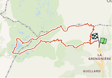
Ruta Senderismo de 12,9 km a descubrir en Auvergne-Rhône-Alpes, Isère, Ornon. Esta ruta ha sido propuesta por rapako.
Descripción
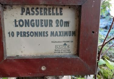
Penser à se garer sur la parking au dessus de la Grenonière pour éviter d'envahir ce paisible hameau.
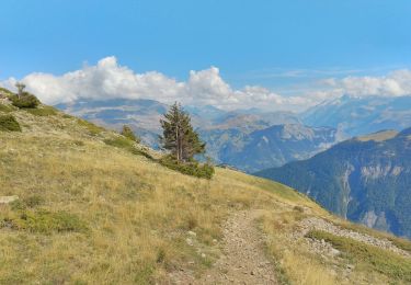
Montée par la Basse Montagne pour profiter au maximum de l'ombre de la forêt.
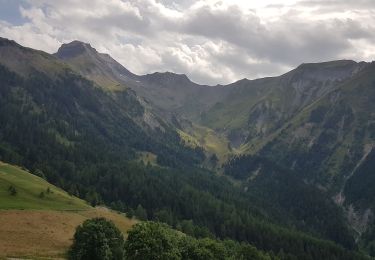
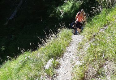
Montée raide (600m de dénivelé en 4km en gros) puis balade sympathique en petites montées-descente sur les 2 plateaux des lacs.
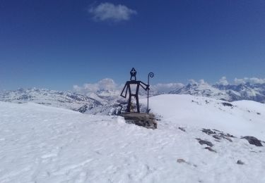
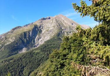
A la descente après le Refuge du Taillefer, vers la Buffe, la vue est splendide sur Belledonne, les Grandes Rousses la Meije et les Ecrins...
Localización
Comentarios
Excursiones cerca
![Excursión Senderismo Le Bourg-d'Oisans - 38 BG d Oisans cascade pisse - Photo](https://media.geolcdn.com/t/375/260/2e81579a-11c0-4302-b399-8bc55cc0dd5f.jpg&format=jpg&maxdim=2)
![Senderismo Senderismo](https://static1.geolcdn.com/sitytour/trail-icons/101.png)
Senderismo
![](/images/other/stat-length.png)
![](https://static1.geolcdn.com/siteimages/upload/files/16400158638029165_repeat_loop_refresh_sync_direction_icon.png)
![Excursión Esquí de fondo Ornon - Le Taillefer - Photo](https://media.geolcdn.com/t/375/260/c574ba01-aae9-4665-88a5-f41d16e34e2a.jpg&format=jpg&maxdim=2)
![Esquí de fondo Esquí de fondo](https://static1.geolcdn.com/sitytour/trail-icons/503.png)
Esquí de fondo
![](/images/other/stat-length.png)
![](https://static1.geolcdn.com/siteimages/upload/files/16400158638029165_repeat_loop_refresh_sync_direction_icon.png)
![Excursión Esquí de fondo Oulles - Le Grand Galbert - Photo](https://media.geolcdn.com/t/375/260/deb5abfe-9d12-4610-a034-8cf37e109247.jpg&format=jpg&maxdim=2)
![Esquí de fondo Esquí de fondo](https://static1.geolcdn.com/sitytour/trail-icons/503.png)
Esquí de fondo
![](/images/other/stat-length.png)
![](https://static1.geolcdn.com/siteimages/upload/files/16400158638029165_repeat_loop_refresh_sync_direction_icon.png)
![Excursión Senderismo Ornon - Plateau des lacs - Photo](https://media.geolcdn.com/t/375/260/95c91083-32aa-44d3-b116-e3d30f3c6317.jpg&format=jpg&maxdim=2)
![Senderismo Senderismo](https://static1.geolcdn.com/sitytour/trail-icons/101.png)
Senderismo
![](/images/other/stat-length.png)
![](https://static1.geolcdn.com/siteimages/upload/files/16400158638029165_repeat_loop_refresh_sync_direction_icon.png)
![Excursión Senderismo Villard-Reymond - La Croix du Carrelet et la crête de Croix de La Garde - Photo](https://media.geolcdn.com/t/375/260/719f71c8-5764-4d7d-9547-f0e72ea0e1f5.jpg&format=jpg&maxdim=2)
![Senderismo Senderismo](https://static1.geolcdn.com/sitytour/trail-icons/101.png)
Senderismo
![](/images/other/stat-length.png)
![](https://static1.geolcdn.com/siteimages/upload/files/16400158638029165_repeat_loop_refresh_sync_direction_icon.png)
![Excursión Senderismo Le Bourg-d'Oisans - Bourg d'Oisans les cascades - Photo](https://media.geolcdn.com/t/375/260/f162be93-5b19-484b-970f-69f2c59af7f2.jpg&format=jpg&maxdim=2)
![Senderismo Senderismo](https://static1.geolcdn.com/sitytour/trail-icons/101.png)
Senderismo
![](/images/other/stat-length.png)
![](https://static1.geolcdn.com/siteimages/upload/files/16400158638029165_repeat_loop_refresh_sync_direction_icon.png)
![Excursión Senderismo Ornon - Plateau des lacs, lac Fourchu. par bergerie - Photo](https://media.geolcdn.com/t/375/260/96726bb9-ed4e-493b-a6c3-1add5f355935.jpg&format=jpg&maxdim=2)
![Senderismo Senderismo](https://static1.geolcdn.com/sitytour/trail-icons/101.png)
Senderismo
![](/images/other/stat-length.png)
![](https://static1.geolcdn.com/siteimages/upload/files/16400158638029165_repeat_loop_refresh_sync_direction_icon.png)
![Excursión Senderismo Villard-Notre-Dame - villard Redmond - Photo](https://media.geolcdn.com/t/375/260/06639bd3-b0d9-4d0a-b2aa-40bb1a3232fe.jpg&format=jpg&maxdim=2)
![Senderismo Senderismo](https://static1.geolcdn.com/sitytour/trail-icons/101.png)
Senderismo
![](/images/other/stat-length.png)
![](https://static1.geolcdn.com/siteimages/upload/files/16400158638029165_repeat_loop_refresh_sync_direction_icon.png)
![Excursión Senderismo Villard-Reymond - Malraux Croix du Carrelet - Photo](https://media.geolcdn.com/t/375/260/ext.jpg?maxdim=2&url=https%3A%2F%2Fservices.sitytrail.com%2FGeolivesWS%2FDownloadMedia.ashx%3FTrailID%3D1042568%26Media%3D20180918145240.jpg)
![Senderismo Senderismo](https://static1.geolcdn.com/sitytour/trail-icons/101.png)
Senderismo
![](/images/other/stat-length.png)
![](https://static1.geolcdn.com/siteimages/upload/files/16400158638029165_repeat_loop_refresh_sync_direction_icon.png)