![](/images/other/stat-length.png)
![Excursión Senderismo Guerlédan - TSM - Le barrage de Guerlédan - Photo](https://media.geolcdn.com/t/1900/400/ext.pjpeg?maxdim=2&url=https%3A%2F%2Fstatic1.geolcdn.com%2Fsiteimages%2Fupload%2Ffiles%2F1553511878bg_sport_marche.png)
TSM - Le barrage de Guerlédan
zanogueb
Usuario
![Longitud](/images/other/stat-length.png)
![Altitud máxima](https://static1.geolcdn.com/siteimages/upload/files/1508320355ic_sort_altitude_max_24dp.png)
![Desnivel positivo](https://static1.geolcdn.com/siteimages/upload/files/1508320355ic_sort_den_pos_24dp.png)
![Km-Effort](/images/other/stat-length.png)
![Altitud mínima](https://static1.geolcdn.com/siteimages/upload/files/1508320355ic_sort_altitude_min_24dp.png)
![Desnivel negativo](https://static1.geolcdn.com/siteimages/upload/files/1508320355ic_sort_den_neg_24dp.png)
![Boucle](https://static1.geolcdn.com/siteimages/upload/files/16400158638029165_repeat_loop_refresh_sync_direction_icon.png)
![Senderismo](https://static1.geolcdn.com/sitytour/trail-icons/101.png)
2h01
Dificultad : Medio
![Escanee este código QR para abrir la excursión en la aplicación SityTrail](https://capi.geolives.com/qq0zvz2zws4bq2lad0pu/sitytour/trails/3273146/qr.png?size=200)
Aplicación GPS de excursión GRATIS
A propósito
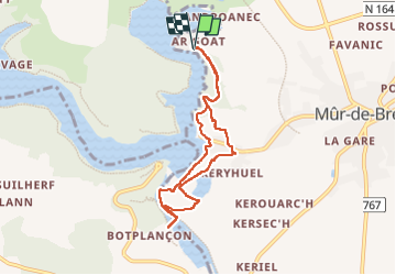
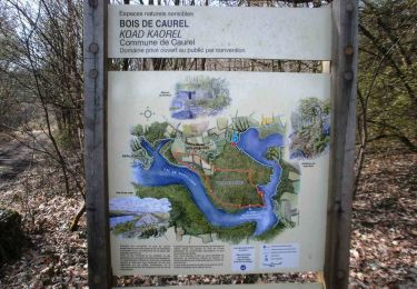
Ruta Senderismo de 7 km a descubrir en Bretaña, Côtes-d'Armor, Guerlédan. Esta ruta ha sido propuesta por zanogueb.
Descripción
Départ du centre Miléade.
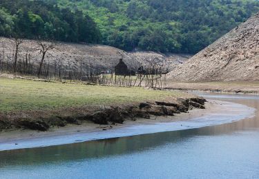
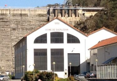
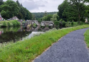
C’est en 1921 que Joseph Ratier, sous-préfet de Pontivy, imagine de barrer le Blavet au niveau de l’écluse de Guerlédan, sur le canal de Nantes à Brest, pour installer une grande usine électrique. Les travaux commencent en 1924.
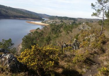
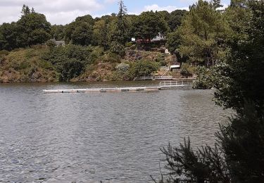
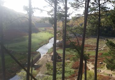
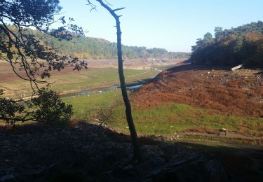
Le barrage et l’usine hydroélectrique sont inaugurés le 12 octobre 1930, 1er barrage construit en béton en France d’une hauteur de 45 mètres et d’une longueur totale de 206 mètres. Il permet de constituer un lac d’une superficie de 304 ha, 12 km de long, 40m de profondeur au plus bas, 51 millions m3 d’eau…
Localización
Comentarios
Excursiones cerca
![Excursión Senderismo Caurel - PR_22_Caurel_AA_01_Circuit1b_Des-Landes-De-Caurel_20150308 - Photo](https://media.geolcdn.com/t/375/260/b7e14f27-fb13-44fd-9480-b8258cbcddf1.jpg&format=jpg&maxdim=2)
![Senderismo Senderismo](https://static1.geolcdn.com/sitytour/trail-icons/101.png)
Senderismo
![](/images/other/stat-length.png)
![](https://static1.geolcdn.com/siteimages/upload/files/16400158638029165_repeat_loop_refresh_sync_direction_icon.png)
![Excursión A pie Caurel - Bois de Caurel - Photo](https://media.geolcdn.com/t/375/260/c37a24f2-46d9-4c23-9518-455adf9e42c9.jpeg&format=jpg&maxdim=2)
![A pie A pie](https://static1.geolcdn.com/sitytour/trail-icons/100.png)
A pie
![](/images/other/stat-length.png)
![](https://static1.geolcdn.com/siteimages/upload/files/16400158638029165_repeat_loop_refresh_sync_direction_icon.png)
![Excursión Senderismo Guerlédan - GR_37_DG_27_Guerledan_Bon-Repos-Blavet_20210828 - Photo](https://media.geolcdn.com/t/375/260/e5650724-4c4a-47c3-a918-73e906fca1b4.jpg&format=jpg&maxdim=2)
![Senderismo Senderismo](https://static1.geolcdn.com/sitytour/trail-icons/101.png)
Senderismo
![](/images/other/stat-length.png)
![](https://static1.geolcdn.com/siteimages/upload/files/16400158638029165_repeat_loop_refresh_sync_direction_icon.png)
![Excursión Senderismo Guerlédan - Variante Guerledan bois de Cornnec Landronnec Voie verte - Photo](https://media.geolcdn.com/t/375/260/0c1715fe-ac58-4eed-b0be-3f99dc5350ec.jpg&format=jpg&maxdim=2)
![Senderismo Senderismo](https://static1.geolcdn.com/sitytour/trail-icons/101.png)
Senderismo
![](/images/other/stat-length.png)
![](https://static1.geolcdn.com/siteimages/upload/files/16400158638029165_repeat_loop_refresh_sync_direction_icon.png)
![Excursión Senderismo Bon Repos sur Blavet - PR_22_Bon-Repos_AA_01_Circuit4_Tregnanton-Et-Lac-Assec_20151025 - Photo](https://media.geolcdn.com/t/375/260/9b560ea5-9972-4252-b9e5-4a77d8bf407a.jpg&format=jpg&maxdim=2)
![Senderismo Senderismo](https://static1.geolcdn.com/sitytour/trail-icons/101.png)
Senderismo
![](/images/other/stat-length.png)
![](https://static1.geolcdn.com/siteimages/upload/files/16400158638029165_repeat_loop_refresh_sync_direction_icon.png)
![Excursión Senderismo Saint-Aignan - GUERLEDAN_02_SORDAN_LAC-A-SEC - Photo](https://media.geolcdn.com/t/375/260/ff049b30-5cc0-4ab9-8e28-9ea2ef15e0d7.jpg&format=jpg&maxdim=2)
![Senderismo Senderismo](https://static1.geolcdn.com/sitytour/trail-icons/101.png)
Senderismo
![](/images/other/stat-length.png)
![](https://static1.geolcdn.com/siteimages/upload/files/16400158638029165_repeat_loop_refresh_sync_direction_icon.png)
![Excursión Senderismo Saint-Aignan - Lac de Guerlédan rive sud - Saint Aignan - Photo](https://media.geolcdn.com/t/375/260/ext.jpg?maxdim=2&url=https%3A%2F%2Fservices.sitytrail.com%2FGeolivesWS%2FDownloadMedia.ashx%3FTrailID%3D129774%26Media%3D13316_6.jpg)
![Senderismo Senderismo](https://static1.geolcdn.com/sitytour/trail-icons/101.png)
Senderismo
![](/images/other/stat-length.png)
![](https://static1.geolcdn.com/siteimages/upload/files/16400158638029165_repeat_loop_refresh_sync_direction_icon.png)
![Excursión Senderismo Guerlédan - Lac de Guerlédan rive Nord - Landroanec - Photo](https://media.geolcdn.com/t/375/260/ext.jpg?maxdim=2&url=https%3A%2F%2Fservices.sitytrail.com%2FGeolivesWS%2FDownloadMedia.ashx%3FTrailID%3D129692%26Media%3D13228_6.jpg)
![Senderismo Senderismo](https://static1.geolcdn.com/sitytour/trail-icons/101.png)
Senderismo
![](/images/other/stat-length.png)
![](https://static1.geolcdn.com/siteimages/upload/files/16400158638029165_repeat_loop_refresh_sync_direction_icon.png)
![Excursión Senderismo Saint-Aignan - guerledan - Photo](https://media.geolcdn.com/t/375/260/611fdb92-b739-4d13-8b2b-20647aa80545.jpg&format=jpg&maxdim=2)
![Senderismo Senderismo](https://static1.geolcdn.com/sitytour/trail-icons/101.png)
Senderismo
![](/images/other/stat-length.png)
![](https://static1.geolcdn.com/siteimages/upload/files/16400158638029165_repeat_loop_refresh_sync_direction_icon.png)