![](/images/other/stat-length.png)
![Excursión A pie Chauchailles - 2022-05-31_19h34m27_gpx-trace - Photo](https://media.geolcdn.com/t/1900/400/ext.pjpeg?maxdim=2&url=https%3A%2F%2Fstatic1.geolcdn.com%2Fsiteimages%2Fupload%2Ffiles%2F1545311037marcheuse_200dpi.jpg)
2022-05-31_19h34m27_gpx-trace
audier
Usuario
![Longitud](/images/other/stat-length.png)
Longitud
22 km
![Altitud máxima](https://static1.geolcdn.com/siteimages/upload/files/1508320355ic_sort_altitude_max_24dp.png)
Altitud máxima
1034 m
![Desnivel positivo](https://static1.geolcdn.com/siteimages/upload/files/1508320355ic_sort_den_pos_24dp.png)
Desnivel positivo
683 m
![Km-Effort](/images/other/stat-length.png)
Km-Effort
31 km
![Altitud mínima](https://static1.geolcdn.com/siteimages/upload/files/1508320355ic_sort_altitude_min_24dp.png)
Altitud mínima
749 m
![Desnivel negativo](https://static1.geolcdn.com/siteimages/upload/files/1508320355ic_sort_den_neg_24dp.png)
Desnivel negativo
685 m
![Boucle](https://static1.geolcdn.com/siteimages/upload/files/16400158638029165_repeat_loop_refresh_sync_direction_icon.png)
Boucle
Sí
Fecha de creación :
2022-05-31 17:34:27.587
Última modificación :
2022-06-01 17:30:28.178
![A pie](https://static1.geolcdn.com/sitytour/trail-icons/100.png)
7h07
Dificultad : Difícil
![Escanee este código QR para abrir la excursión en la aplicación SityTrail](https://capi.geolives.com/qq0zvz2zws4bq2lad0pu/sitytour/trails/3265112/qr.png?size=200)
Aplicación GPS de excursión GRATIS
A propósito
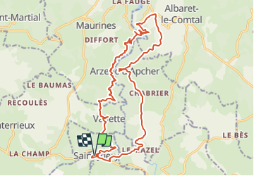
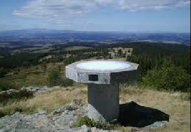
Ruta A pie de 22 km a descubrir en Occitania, Lozère, Chauchailles. Esta ruta ha sido propuesta por audier.
Descripción
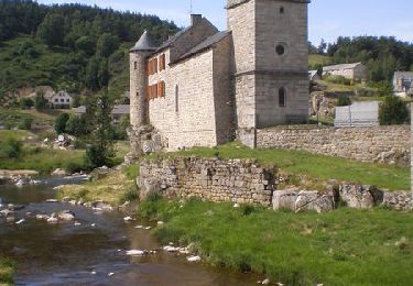
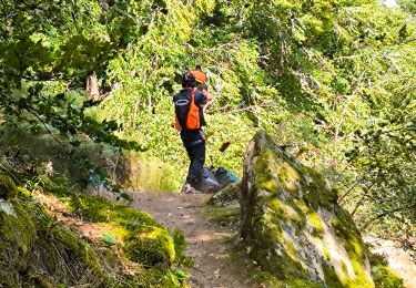
Circuit au départ de Saint Juéry(48),vous mènera au site médiéval de Arzenc d'Apcher,puis un sentier balcon qui domine les gorges de BES. Randonnée proposée par FFRP.
Localización
País:
France
Región :
Occitania
Departamento/provincia :
Lozère
Municipio :
Chauchailles
Localidad:
Unknown
Salida:(Dec)
Salida:(UTM)
506696 ; 4963592 (31T) N.
Comentarios
Excursiones cerca
![Excursión Senderismo Maurines - LES GORGES DU BES - Photo](https://media.geolcdn.com/t/375/260/ext.jpg?maxdim=2&url=https%3A%2F%2Fstatic1.geolcdn.com%2Fsiteimages%2Fupload%2Ffiles%2F1553511878bg_sport_marche.png)
![Senderismo Senderismo](https://static1.geolcdn.com/sitytour/trail-icons/101.png)
LES GORGES DU BES
Senderismo
Medio
(1)
Maurines,
Auvergne-Rhône-Alpes,
Cantal,
France
![](/images/other/stat-length.png)
6,5 km | 9,2 km-effort
2h 5min
![](https://static1.geolcdn.com/siteimages/upload/files/16400158638029165_repeat_loop_refresh_sync_direction_icon.png)
Sí
![Excursión Senderismo Chauchailles - sentier des espagnols - Photo](https://media.geolcdn.com/t/375/260/3a0f3874-78ce-48ea-a436-24dea33476d2.jpg&format=jpg&maxdim=2)
![Senderismo Senderismo](https://static1.geolcdn.com/sitytour/trail-icons/101.png)
sentier des espagnols
Senderismo
Difícil
Chauchailles,
Occitania,
Lozère,
France
![](/images/other/stat-length.png)
22 km | 32 km-effort
6h 48min
![](https://static1.geolcdn.com/siteimages/upload/files/16400158638029165_repeat_loop_refresh_sync_direction_icon.png)
Sí
![Excursión Senderismo Chauchailles - Gorges du Bèz sentier des espagnols - Photo](https://media.geolcdn.com/t/375/260/9def8888-645c-4270-a3bb-b3f990eb7ef3.jpg&format=jpg&maxdim=2)
![Senderismo Senderismo](https://static1.geolcdn.com/sitytour/trail-icons/101.png)
Gorges du Bèz sentier des espagnols
Senderismo
Muy difícil
Chauchailles,
Occitania,
Lozère,
France
![](/images/other/stat-length.png)
22 km | 31 km-effort
7h 34min
![](https://static1.geolcdn.com/siteimages/upload/files/16400158638029165_repeat_loop_refresh_sync_direction_icon.png)
Sí
![Excursión Senderismo Fournels - De Fournels à St-Chély-d'Apcher - Photo](https://media.geolcdn.com/t/375/260/ext.jpg?maxdim=2&url=https%3A%2F%2Fservices.sitytrail.com%2FGeolivesWS%2FDownloadMedia.ashx%3FTrailID%3D172923%26Media%3D14391_4.jpg)
![Senderismo Senderismo](https://static1.geolcdn.com/sitytour/trail-icons/101.png)
De Fournels à St-Chély-d'Apcher
Senderismo
Difícil
Fournels,
Occitania,
Lozère,
France
![](/images/other/stat-length.png)
17,7 km | 23 km-effort
4h 10min
![](https://static1.geolcdn.com/siteimages/upload/files/16400158638029165_repeat_loop_refresh_sync_direction_icon.png)
No
![Excursión Senderismo Chauchailles - Les Gorges du Bes - Photo](https://media.geolcdn.com/t/375/260/ext.jpg?maxdim=2&url=https%3A%2F%2Fservices.sitytrail.com%2FGeolivesWS%2FDownloadMedia.ashx%3FTrailID%3D103575%26Media%3D5887_6.jpg)
![Senderismo Senderismo](https://static1.geolcdn.com/sitytour/trail-icons/101.png)
Les Gorges du Bes
Senderismo
Difícil
(1)
Chauchailles,
Occitania,
Lozère,
France
![](/images/other/stat-length.png)
21 km | 30 km-effort
7h 0min
![](https://static1.geolcdn.com/siteimages/upload/files/16400158638029165_repeat_loop_refresh_sync_direction_icon.png)
Sí
![Excursión Senderismo Chauchailles - les Gorges du Bes - Photo](https://media.geolcdn.com/t/375/260/c987b7ea-518c-4395-9a06-f2e4d18857b3.jpg&format=jpg&maxdim=2)
![Senderismo Senderismo](https://static1.geolcdn.com/sitytour/trail-icons/101.png)
les Gorges du Bes
Senderismo
Medio
Chauchailles,
Occitania,
Lozère,
France
![](/images/other/stat-length.png)
15,3 km | 21 km-effort
7h 7min
![](https://static1.geolcdn.com/siteimages/upload/files/16400158638029165_repeat_loop_refresh_sync_direction_icon.png)
Sí
![Excursión Senderismo Maurines - le bez,départ de Morsange - Photo](https://media.geolcdn.com/t/375/260/cc92de9d-7380-4c80-864d-95d9776c7c38.jpg&format=jpg&maxdim=2)
![Senderismo Senderismo](https://static1.geolcdn.com/sitytour/trail-icons/101.png)
le bez,départ de Morsange
Senderismo
Medio
Maurines,
Auvergne-Rhône-Alpes,
Cantal,
France
![](/images/other/stat-length.png)
6,6 km | 9,3 km-effort
2h 45min
![](https://static1.geolcdn.com/siteimages/upload/files/16400158638029165_repeat_loop_refresh_sync_direction_icon.png)
Sí
![Excursión Senderismo Saint-Juéry - Le Bes - Photo](https://media.geolcdn.com/t/375/260/ab6404e2-993f-412a-b877-fdd25667143f.jpg&format=jpg&maxdim=2)
![Senderismo Senderismo](https://static1.geolcdn.com/sitytour/trail-icons/101.png)
![Excursión Senderismo Deux-Verges - Le Puy de la Tuile - Photo](https://media.geolcdn.com/t/375/260/8c8e0d8f-973f-4cd5-97ab-09ffcd850d61.jpg&format=jpg&maxdim=2)
![Senderismo Senderismo](https://static1.geolcdn.com/sitytour/trail-icons/101.png)
Le Puy de la Tuile
Senderismo
Medio
Deux-Verges,
Auvergne-Rhône-Alpes,
Cantal,
France
![](/images/other/stat-length.png)
8,9 km | 12,5 km-effort
3h 0min
![](https://static1.geolcdn.com/siteimages/upload/files/16400158638029165_repeat_loop_refresh_sync_direction_icon.png)
Sí