![](/images/other/stat-length.png)
![Excursión Senderismo Profondeville - PROFONDEVILLE _ Marche Fédérale _ NA _ 22/05/2022 - Photo](https://media.geolcdn.com/t/1900/400/87777c3e-1b13-4791-82dd-1aafe0ff86d4.jpg&format=pjpeg&maxdim=2)
PROFONDEVILLE _ Marche Fédérale _ NA _ 22/05/2022
jeangulu
Usuario
![Longitud](/images/other/stat-length.png)
Longitud
31 km
![Altitud máxima](https://static1.geolcdn.com/siteimages/upload/files/1508320355ic_sort_altitude_max_24dp.png)
Altitud máxima
288 m
![Desnivel positivo](https://static1.geolcdn.com/siteimages/upload/files/1508320355ic_sort_den_pos_24dp.png)
Desnivel positivo
907 m
![Km-Effort](/images/other/stat-length.png)
Km-Effort
44 km
![Altitud mínima](https://static1.geolcdn.com/siteimages/upload/files/1508320355ic_sort_altitude_min_24dp.png)
Altitud mínima
76 m
![Desnivel negativo](https://static1.geolcdn.com/siteimages/upload/files/1508320355ic_sort_den_neg_24dp.png)
Desnivel negativo
909 m
![Boucle](https://static1.geolcdn.com/siteimages/upload/files/16400158638029165_repeat_loop_refresh_sync_direction_icon.png)
Boucle
Sí
Fecha de creación :
2022-05-22 07:37:10.428
Última modificación :
2022-05-22 14:59:46.064
![Senderismo](https://static1.geolcdn.com/sitytour/trail-icons/101.png)
7h21
Dificultad : Difícil
![Escanee este código QR para abrir la excursión en la aplicación SityTrail](https://capi.geolives.com/qq0zvz2zws4bq2lad0pu/sitytour/trails/3252804/qr.png?size=200)
Aplicación GPS de excursión GRATIS
A propósito
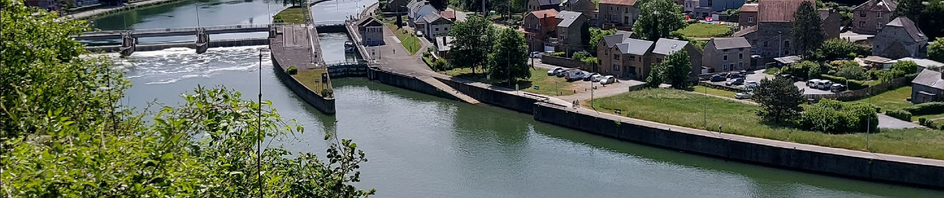
Ruta Senderismo de 31 km a descubrir en Valonia, Namur, Profondeville. Esta ruta ha sido propuesta por jeangulu.
Descripción
Point de départ : Maison de la Culture - Rue Colonel Bourg, 2 - 5170 PROFONDEVILLE.
Organisateur : NA 031 - LES HULL'OTTES -PROFONDEVILLE ASBL.
Localización
País:
Belgium
Región :
Valonia
Departamento/provincia :
Namur
Municipio :
Profondeville
Localidad:
Profondeville
Salida:(Dec)
Salida:(UTM)
632974 ; 5582385 (31U) N.
Comentarios
Excursiones cerca
![Excursión Senderismo Profondeville - GG-Na-19_ Lustin - Namur - Photo](https://media.geolcdn.com/t/375/260/b0b5ef2e-bf0c-4965-a3a2-62d0da2d07c7.jpg&format=jpg&maxdim=2)
![Senderismo Senderismo](https://static1.geolcdn.com/sitytour/trail-icons/101.png)
GG-Na-19_ Lustin - Namur
Senderismo
Muy difícil
(13)
Profondeville,
Valonia,
Namur,
Belgium
![](/images/other/stat-length.png)
22 km | 28 km-effort
6h 7min
![](https://static1.geolcdn.com/siteimages/upload/files/16400158638029165_repeat_loop_refresh_sync_direction_icon.png)
No
![Senderismo Senderismo](https://static1.geolcdn.com/sitytour/trail-icons/101.png)
RB-Na-21-Terres seigneuriales et carrières de la vallée du Bocq
Senderismo
Muy difícil
(6)
Yvoir,
Valonia,
Namur,
Belgium
![](/images/other/stat-length.png)
22 km | 30 km-effort
6h 51min
![](https://static1.geolcdn.com/siteimages/upload/files/16400158638029165_repeat_loop_refresh_sync_direction_icon.png)
Sí
![Senderismo Senderismo](https://static1.geolcdn.com/sitytour/trail-icons/101.png)
RB-Na-20-Raccourci-2_Paysages_entre_Meuse_et_Burnot
Senderismo
Muy difícil
(11)
Profondeville,
Valonia,
Namur,
Belgium
![](/images/other/stat-length.png)
14,6 km | 22 km-effort
4h 53min
![](https://static1.geolcdn.com/siteimages/upload/files/16400158638029165_repeat_loop_refresh_sync_direction_icon.png)
Sí
![Senderismo Senderismo](https://static1.geolcdn.com/sitytour/trail-icons/101.png)
RB-Na-20-Paysages_entre_Meuse_et_Burnot
Senderismo
Muy difícil
(16)
Profondeville,
Valonia,
Namur,
Belgium
![](/images/other/stat-length.png)
18,5 km | 26 km-effort
5h 55min
![](https://static1.geolcdn.com/siteimages/upload/files/16400158638029165_repeat_loop_refresh_sync_direction_icon.png)
Sí
![Excursión Senderismo Yvoir - GG2-Na-38_Godinne-Dinant (2021-11-04) - Photo](https://media.geolcdn.com/t/375/260/4b7f8162-b405-4557-afe1-7567462c4aff.jpg&format=jpg&maxdim=2)
![Senderismo Senderismo](https://static1.geolcdn.com/sitytour/trail-icons/101.png)
GG2-Na-38_Godinne-Dinant (2021-11-04)
Senderismo
Muy difícil
(6)
Yvoir,
Valonia,
Namur,
Belgium
![](/images/other/stat-length.png)
19,5 km | 27 km-effort
6h 13min
![](https://static1.geolcdn.com/siteimages/upload/files/16400158638029165_repeat_loop_refresh_sync_direction_icon.png)
No
![Excursión Senderismo Anhée - RF-Na-05 Annevoie, côté Jardins_Grande-boucle - Photo](https://media.geolcdn.com/t/375/260/ext.jpg?maxdim=2&url=https%3A%2F%2Fservices.sitytrail.com%2FGeolivesWS%2FDownloadMedia.ashx%3FTrailID%3D545753%26Media%3D5d973c83-4a6c-40fc-a026-25de6c754887.JPG)
![Senderismo Senderismo](https://static1.geolcdn.com/sitytour/trail-icons/101.png)
RF-Na-05 Annevoie, côté Jardins_Grande-boucle
Senderismo
Medio
(11)
Anhée,
Valonia,
Namur,
Belgium
![](/images/other/stat-length.png)
11,3 km | 14,5 km-effort
3h 6min
![](https://static1.geolcdn.com/siteimages/upload/files/16400158638029165_repeat_loop_refresh_sync_direction_icon.png)
Sí
![Excursión Senderismo Anhée - RF-Na-05 Annevoie, côté Jardins_Petite-boucle - Photo](https://media.geolcdn.com/t/375/260/ext.jpg?maxdim=2&url=https%3A%2F%2Fservices.sitytrail.com%2FGeolivesWS%2FDownloadMedia.ashx%3FTrailID%3D545751%26Media%3D5d973c83-4a6c-40fc-a026-25de6c754887.JPG)
![Senderismo Senderismo](https://static1.geolcdn.com/sitytour/trail-icons/101.png)
RF-Na-05 Annevoie, côté Jardins_Petite-boucle
Senderismo
Fácil
(7)
Anhée,
Valonia,
Namur,
Belgium
![](/images/other/stat-length.png)
7,4 km | 10 km-effort
2h 7min
![](https://static1.geolcdn.com/siteimages/upload/files/16400158638029165_repeat_loop_refresh_sync_direction_icon.png)
Sí
![Excursión Senderismo Namur - De Naninne vers Dave par les Fonds de Lustin et les Bois d'Acremont - Photo](https://media.geolcdn.com/t/375/260/ext.jpg?maxdim=2&url=https%3A%2F%2Fstatic1.geolcdn.com%2Fsiteimages%2Fupload%2Ffiles%2F1553511878bg_sport_marche.png)
![Senderismo Senderismo](https://static1.geolcdn.com/sitytour/trail-icons/101.png)
De Naninne vers Dave par les Fonds de Lustin et les Bois d'Acremont
Senderismo
Medio
(5)
Namur,
Valonia,
Namur,
Belgium
![](/images/other/stat-length.png)
19 km | 25 km-effort
5h 0min
![](https://static1.geolcdn.com/siteimages/upload/files/16400158638029165_repeat_loop_refresh_sync_direction_icon.png)
Sí
![Excursión Senderismo Profondeville - Profondeville - Photo](https://media.geolcdn.com/t/375/260/f2691757-ffd7-4f68-a5e0-1d2bff857008.jpg&format=jpg&maxdim=2)
![Senderismo Senderismo](https://static1.geolcdn.com/sitytour/trail-icons/101.png)
Profondeville
Senderismo
Medio
(1)
Profondeville,
Valonia,
Namur,
Belgium
![](/images/other/stat-length.png)
16,7 km | 25 km-effort
3h 49min
![](https://static1.geolcdn.com/siteimages/upload/files/16400158638029165_repeat_loop_refresh_sync_direction_icon.png)
Sí