![](/images/other/stat-length.png)
![Excursión Senderismo Marsella - 20220512. Marseille, Vieux-Port, l'Estaque, pl. Joliette - Photo](https://media.geolcdn.com/t/1900/400/fcdab9d4-c32e-4a71-bee2-fb61eab07b24.jpg&format=pjpeg&maxdim=2)
20220512. Marseille, Vieux-Port, l'Estaque, pl. Joliette
hal2012
Usuario
![Longitud](/images/other/stat-length.png)
Longitud
16,8 km
![Altitud máxima](https://static1.geolcdn.com/siteimages/upload/files/1508320355ic_sort_altitude_max_24dp.png)
Altitud máxima
49 m
![Desnivel positivo](https://static1.geolcdn.com/siteimages/upload/files/1508320355ic_sort_den_pos_24dp.png)
Desnivel positivo
196 m
![Km-Effort](/images/other/stat-length.png)
Km-Effort
19,4 km
![Altitud mínima](https://static1.geolcdn.com/siteimages/upload/files/1508320355ic_sort_altitude_min_24dp.png)
Altitud mínima
-2 m
![Desnivel negativo](https://static1.geolcdn.com/siteimages/upload/files/1508320355ic_sort_den_neg_24dp.png)
Desnivel negativo
187 m
![Boucle](https://static1.geolcdn.com/siteimages/upload/files/16400158638029165_repeat_loop_refresh_sync_direction_icon.png)
Boucle
No
Fecha de creación :
2022-05-12 08:43:25.381
Última modificación :
2022-05-12 16:52:15.97
![Senderismo](https://static1.geolcdn.com/sitytour/trail-icons/101.png)
6h03
Dificultad : Fácil
![Escanee este código QR para abrir la excursión en la aplicación SityTrail](https://capi.geolives.com/qq0zvz2zws4bq2lad0pu/sitytour/trails/3239809/qr.png?size=200)
Aplicación GPS de excursión GRATIS
A propósito
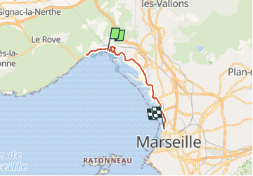
Ruta Senderismo de 16,8 km a descubrir en Provenza-Alpes-Costa Azul, Bocas del Ródano, Marsella. Esta ruta ha sido propuesta por hal2012.
Descripción
Aller en bateau.
Balade dans l'Estaque.
Retour bus 35 17h35... 18h
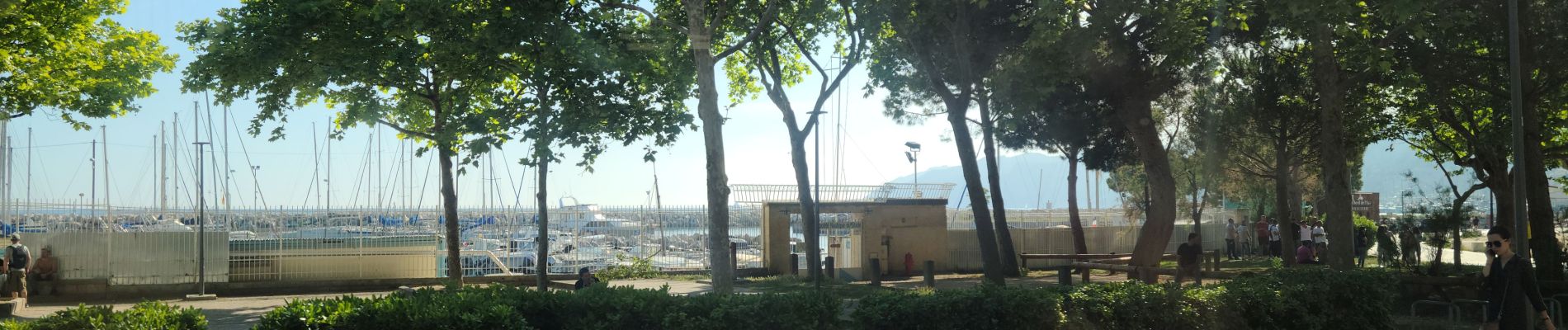
Terrasses du port.
Fin parcours pl. Joliette 18h50
Localización
País:
France
Región :
Provenza-Alpes-Costa Azul
Departamento/provincia :
Bocas del Ródano
Municipio :
Marsella
Localidad:
16e Arrondissement
Salida:(Dec)
Salida:(UTM)
687247 ; 4803519 (31T) N.
Comentarios
Excursiones cerca
![Excursión Senderismo Le Rove - Calanque de la Vesse - Niolon la Vesse - Photo](https://media.geolcdn.com/t/375/260/ext.jpg?maxdim=2&url=https%3A%2F%2Fservices.sitytrail.com%2FGeolivesWS%2FDownloadMedia.ashx%3FTrailID%3D173014%26Media%3D14517_3.jpg)
![Senderismo Senderismo](https://static1.geolcdn.com/sitytour/trail-icons/101.png)
Calanque de la Vesse - Niolon la Vesse
Senderismo
Medio
(1)
Le Rove,
Provenza-Alpes-Costa Azul,
Bocas del Ródano,
France
![](/images/other/stat-length.png)
5,7 km | 8,3 km-effort
2h 15min
![](https://static1.geolcdn.com/siteimages/upload/files/16400158638029165_repeat_loop_refresh_sync_direction_icon.png)
Sí
![Excursión Senderismo Marsella - Marseille Estaque à Redonne - Photo](https://media.geolcdn.com/t/375/260/340207fd-a5d2-463a-a208-d159b4a5061b.jpg&format=jpg&maxdim=2)
![Senderismo Senderismo](https://static1.geolcdn.com/sitytour/trail-icons/101.png)
Marseille Estaque à Redonne
Senderismo
Muy difícil
Marsella,
Provenza-Alpes-Costa Azul,
Bocas del Ródano,
France
![](/images/other/stat-length.png)
14,5 km | 20 km-effort
4h 24min
![](https://static1.geolcdn.com/siteimages/upload/files/16400158638029165_repeat_loop_refresh_sync_direction_icon.png)
No
![Excursión Senderismo Le Rove - Côté bleue - Photo](https://media.geolcdn.com/t/375/260/fb6332a1-2d00-4409-b098-eb5bb9797d34.jpg&format=jpg&maxdim=2)
![Senderismo Senderismo](https://static1.geolcdn.com/sitytour/trail-icons/101.png)
Côté bleue
Senderismo
Difícil
Le Rove,
Provenza-Alpes-Costa Azul,
Bocas del Ródano,
France
![](/images/other/stat-length.png)
13,2 km | 18,7 km-effort
4h 39min
![](https://static1.geolcdn.com/siteimages/upload/files/16400158638029165_repeat_loop_refresh_sync_direction_icon.png)
Sí
![Excursión A pie Le Rove - Le fort de Niolon - Photo](https://media.geolcdn.com/t/375/260/93364f75-dc6d-4cba-b606-eb4abcda53d9.jpeg&format=jpg&maxdim=2)
![A pie A pie](https://static1.geolcdn.com/sitytour/trail-icons/100.png)
Le fort de Niolon
A pie
Fácil
Le Rove,
Provenza-Alpes-Costa Azul,
Bocas del Ródano,
France
![](/images/other/stat-length.png)
4,2 km | 6,6 km-effort
1h 29min
![](https://static1.geolcdn.com/siteimages/upload/files/16400158638029165_repeat_loop_refresh_sync_direction_icon.png)
Sí
![Excursión Senderismo Le Rove - de Niolon à l'Erévine - Photo](https://media.geolcdn.com/t/375/260/4bb4e4f1-8064-4508-97a7-6fadcd44a858.jpg&format=jpg&maxdim=2)
![Senderismo Senderismo](https://static1.geolcdn.com/sitytour/trail-icons/101.png)
de Niolon à l'Erévine
Senderismo
Fácil
(1)
Le Rove,
Provenza-Alpes-Costa Azul,
Bocas del Ródano,
France
![](/images/other/stat-length.png)
7,3 km | 11,1 km-effort
2h 47min
![](https://static1.geolcdn.com/siteimages/upload/files/16400158638029165_repeat_loop_refresh_sync_direction_icon.png)
Sí
![Excursión Senderismo Le Rove - Cote bleue - Photo](https://media.geolcdn.com/t/375/260/ext.jpg?maxdim=2&url=https%3A%2F%2Fservices.sitytrail.com%2FGeolivesWS%2FDownloadMedia.ashx%3FTrailID%3D1137457%26Media%3Dfix__20190421151733.jpg)
![Senderismo Senderismo](https://static1.geolcdn.com/sitytour/trail-icons/101.png)
Cote bleue
Senderismo
Difícil
Le Rove,
Provenza-Alpes-Costa Azul,
Bocas del Ródano,
France
![](/images/other/stat-length.png)
18,7 km | 26 km-effort
6h 48min
![](https://static1.geolcdn.com/siteimages/upload/files/16400158638029165_repeat_loop_refresh_sync_direction_icon.png)
Sí
![Excursión Senderismo Le Rove - le Rove - Photo](https://media.geolcdn.com/t/375/260/a57a04ed-8c7b-414d-b81a-6cd022e3b570.jpeg&format=jpg&maxdim=2)
![Senderismo Senderismo](https://static1.geolcdn.com/sitytour/trail-icons/101.png)
le Rove
Senderismo
Fácil
(1)
Le Rove,
Provenza-Alpes-Costa Azul,
Bocas del Ródano,
France
![](/images/other/stat-length.png)
8,7 km | 11,5 km-effort
2h 32min
![](https://static1.geolcdn.com/siteimages/upload/files/16400158638029165_repeat_loop_refresh_sync_direction_icon.png)
Sí
![Excursión Senderismo Marsella - Sausset les Pins - Marseille - Photo](https://media.geolcdn.com/t/375/260/ext.jpg?maxdim=2&url=https%3A%2F%2Fstatic1.geolcdn.com%2Fsiteimages%2Fupload%2Ffiles%2F1553511878bg_sport_marche.png)
![Senderismo Senderismo](https://static1.geolcdn.com/sitytour/trail-icons/101.png)
Sausset les Pins - Marseille
Senderismo
Difícil
(1)
Marsella,
Provenza-Alpes-Costa Azul,
Bocas del Ródano,
France
![](/images/other/stat-length.png)
25 km | 33 km-effort
7h 7min
![](https://static1.geolcdn.com/siteimages/upload/files/16400158638029165_repeat_loop_refresh_sync_direction_icon.png)
No
![Excursión Senderismo Le Rove - de l'Establon au port de la Vesse - Photo](https://media.geolcdn.com/t/375/260/ext.jpg?maxdim=2&url=https%3A%2F%2Fservices.sitytrail.com%2FGeolivesWS%2FDownloadMedia.ashx%3FTrailID%3D650476%26Media%3Dfix__20161024160503.jpg)
![Senderismo Senderismo](https://static1.geolcdn.com/sitytour/trail-icons/101.png)
de l'Establon au port de la Vesse
Senderismo
Fácil
Le Rove,
Provenza-Alpes-Costa Azul,
Bocas del Ródano,
France
![](/images/other/stat-length.png)
9 km | 13,5 km-effort
5h 9min
![](https://static1.geolcdn.com/siteimages/upload/files/16400158638029165_repeat_loop_refresh_sync_direction_icon.png)
Sí