![](/images/other/stat-length.png)
![Excursión Senderismo Ormoy-le-Davien - 060522 - Ormoy le Davien - La Ferté Milon - Photo](https://media.geolcdn.com/t/1900/400/9796922a-107f-4281-b115-7bc0491a4bb5.jpg&format=pjpeg&maxdim=2)
060522 - Ormoy le Davien - La Ferté Milon
Vadim
Usuario
![Longitud](/images/other/stat-length.png)
![Altitud máxima](https://static1.geolcdn.com/siteimages/upload/files/1508320355ic_sort_altitude_max_24dp.png)
![Desnivel positivo](https://static1.geolcdn.com/siteimages/upload/files/1508320355ic_sort_den_pos_24dp.png)
![Km-Effort](/images/other/stat-length.png)
![Altitud mínima](https://static1.geolcdn.com/siteimages/upload/files/1508320355ic_sort_altitude_min_24dp.png)
![Desnivel negativo](https://static1.geolcdn.com/siteimages/upload/files/1508320355ic_sort_den_neg_24dp.png)
![Boucle](https://static1.geolcdn.com/siteimages/upload/files/16400158638029165_repeat_loop_refresh_sync_direction_icon.png)
![Senderismo](https://static1.geolcdn.com/sitytour/trail-icons/101.png)
6h42
Dificultad : Difícil
![Escanee este código QR para abrir la excursión en la aplicación SityTrail](https://capi.geolives.com/qq0zvz2zws4bq2lad0pu/sitytour/trails/3231913/qr.png?size=200)
Aplicación GPS de excursión GRATIS
A propósito
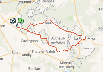
Ruta Senderismo de 32 km a descubrir en Alta Francia, Oise, Ormoy-le-Davien. Esta ruta ha sido propuesta por Vadim.
Descripción
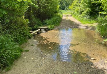
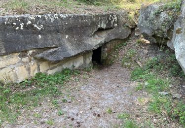
Dans cette rando, il y a 3 ou 4 chemins de /- une centaine de mètres chacun qui ont disparu dans la végétation, mais on devine encore leurs tracées sur le terrain...
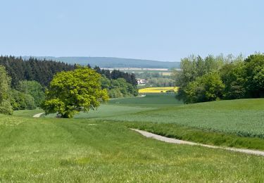
Aussi pour faire un vrai boucle, mais sans trop rallonger la rando, il faut parfois, lors du retour, couper à travers champs. En restant dans le sillage d'une roue de tracteur et en longeant parfois les lisières de forêts, on s'en sort très bien.
Localización
Comentarios
Excursiones cerca
![Excursión Senderismo Ormoy-le-Davien - 140722 - Ormoy le Davien - Etan de Wallu - Photo](https://media.geolcdn.com/t/375/260/a0fa9d10-3fbc-418f-863b-991340583e78.jpg&format=jpg&maxdim=2)
![Senderismo Senderismo](https://static1.geolcdn.com/sitytour/trail-icons/101.png)
Senderismo
![](/images/other/stat-length.png)
![](https://static1.geolcdn.com/siteimages/upload/files/16400158638029165_repeat_loop_refresh_sync_direction_icon.png)
![Excursión Senderismo Ormoy-le-Davien - 060722 - Petite rando 10 km - Photo](https://media.geolcdn.com/t/375/260/15cf419f-e6f6-44c3-8671-97fc060afa84.jpg&format=jpg&maxdim=2)
![Senderismo Senderismo](https://static1.geolcdn.com/sitytour/trail-icons/101.png)
Senderismo
![](/images/other/stat-length.png)
![](https://static1.geolcdn.com/siteimages/upload/files/16400158638029165_repeat_loop_refresh_sync_direction_icon.png)
![Excursión Bici de montaña Ormoy-le-Davien - 130522 - Boucle VTT - Ormoy le davien en passant par le canal de l'Ourc - Photo](https://media.geolcdn.com/t/375/260/feba87b7-69e0-4b33-bb6b-f9399a3fff45.jpg&format=jpg&maxdim=2)
![Bici de montaña Bici de montaña](https://static1.geolcdn.com/sitytour/trail-icons/202.png)
Bici de montaña
![](/images/other/stat-length.png)
![](https://static1.geolcdn.com/siteimages/upload/files/16400158638029165_repeat_loop_refresh_sync_direction_icon.png)
![Excursión Senderismo Ormoy-le-Davien - 040522 - Boucle Ormoy le Davien - Moulin de Wallu... - Photo](https://media.geolcdn.com/t/375/260/4754e98c-e981-4349-bd96-fb3e5130af09.jpg&format=jpg&maxdim=2)
![Senderismo Senderismo](https://static1.geolcdn.com/sitytour/trail-icons/101.png)
Senderismo
![](/images/other/stat-length.png)
![](https://static1.geolcdn.com/siteimages/upload/files/16400158638029165_repeat_loop_refresh_sync_direction_icon.png)
![Excursión Senderismo Ormoy-le-Davien - 030422 - Direction Vaucienne puis Vaumoise et Cave du diable - Photo](https://media.geolcdn.com/t/375/260/0e67b0e5-82d9-4aeb-838c-c1eadb0b350a.jpg&format=jpg&maxdim=2)
![Senderismo Senderismo](https://static1.geolcdn.com/sitytour/trail-icons/101.png)
Senderismo
![](/images/other/stat-length.png)
![](https://static1.geolcdn.com/siteimages/upload/files/16400158638029165_repeat_loop_refresh_sync_direction_icon.png)
![Excursión Senderismo Ormoy-le-Davien - 290422 - Boucle Ormoy le Davien - au dessus de Chavre - Photo](https://media.geolcdn.com/t/375/260/d6fcf672-f1b4-4299-8bcc-208d1567912b.jpg&format=jpg&maxdim=2)
![Senderismo Senderismo](https://static1.geolcdn.com/sitytour/trail-icons/101.png)
Senderismo
![](/images/other/stat-length.png)
![](https://static1.geolcdn.com/siteimages/upload/files/16400158638029165_repeat_loop_refresh_sync_direction_icon.png)
![Excursión Senderismo Ormoy-le-Davien - Ormoy - Cave du diable - Photo](https://media.geolcdn.com/t/375/260/934b883f-dc95-49b7-87b5-48cebc3b6bdb.jpg&format=jpg&maxdim=2)
![Senderismo Senderismo](https://static1.geolcdn.com/sitytour/trail-icons/101.png)
Senderismo
![](/images/other/stat-length.png)
![](https://static1.geolcdn.com/siteimages/upload/files/16400158638029165_repeat_loop_refresh_sync_direction_icon.png)
![Excursión Senderismo Ormoy-le-Davien - Boucle départ Ormoy le Davien 60620 - Foret de Retz - Photo](https://media.geolcdn.com/t/375/260/7b73f2ec-6e9e-46eb-b206-78debe313e7c.jpg&format=jpg&maxdim=2)
![Senderismo Senderismo](https://static1.geolcdn.com/sitytour/trail-icons/101.png)
Senderismo
![](/images/other/stat-length.png)
![](https://static1.geolcdn.com/siteimages/upload/files/16400158638029165_repeat_loop_refresh_sync_direction_icon.png)
![Excursión Bici de montaña Ormoy-le-Davien - Boucle Ormoy le Davien - Mareuil sur Ourcq - Ormoy le Davien - Photo](https://media.geolcdn.com/t/375/260/35fa14d0-9f41-4e21-b1f4-6f0f01120ccb.jpg&format=jpg&maxdim=2)
![Bici de montaña Bici de montaña](https://static1.geolcdn.com/sitytour/trail-icons/202.png)
Bici de montaña
![](/images/other/stat-length.png)
![](https://static1.geolcdn.com/siteimages/upload/files/16400158638029165_repeat_loop_refresh_sync_direction_icon.png)