![](/images/other/stat-length.png)
![Excursión Senderismo L'Épine - Les Marais de Luzeronde - Photo](https://media.geolcdn.com/t/1900/400/ext.pjpeg?maxdim=2&url=https%3A%2F%2Fstatic1.geolcdn.com%2Fsiteimages%2Fupload%2Ffiles%2F1553511878bg_sport_marche.png)
Les Marais de Luzeronde
rogerpoirier
Usuario
![Longitud](/images/other/stat-length.png)
![Altitud máxima](https://static1.geolcdn.com/siteimages/upload/files/1508320355ic_sort_altitude_max_24dp.png)
![Desnivel positivo](https://static1.geolcdn.com/siteimages/upload/files/1508320355ic_sort_den_pos_24dp.png)
![Km-Effort](/images/other/stat-length.png)
![Altitud mínima](https://static1.geolcdn.com/siteimages/upload/files/1508320355ic_sort_altitude_min_24dp.png)
![Desnivel negativo](https://static1.geolcdn.com/siteimages/upload/files/1508320355ic_sort_den_neg_24dp.png)
![Boucle](https://static1.geolcdn.com/siteimages/upload/files/16400158638029165_repeat_loop_refresh_sync_direction_icon.png)
![Senderismo](https://static1.geolcdn.com/sitytour/trail-icons/101.png)
1h39
Dificultad : Medio
![Escanee este código QR para abrir la excursión en la aplicación SityTrail](https://capi.geolives.com/qq0zvz2zws4bq2lad0pu/sitytour/trails/3222416/qr.png?size=200)
Aplicación GPS de excursión GRATIS
A propósito
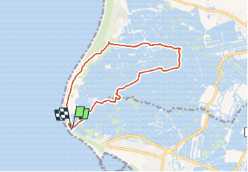
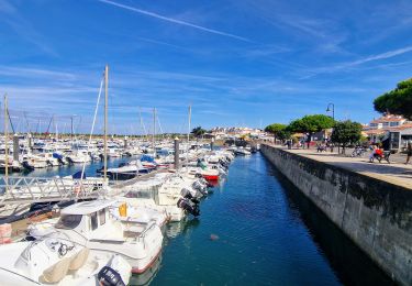
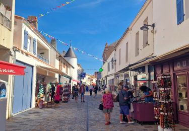
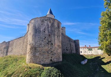
Ruta Senderismo de 6,9 km a descubrir en Países del Loira, Vandea, L'Épine. Esta ruta ha sido propuesta por rogerpoirier.
Descripción
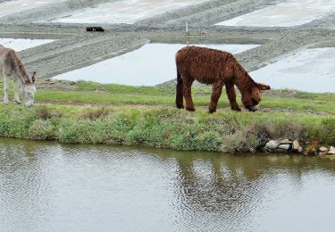
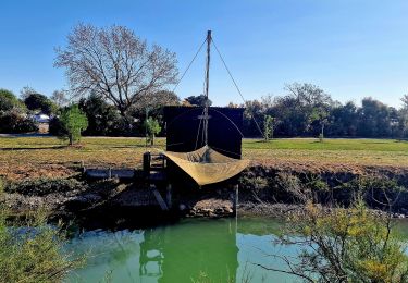
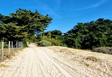
En partant du parking de La Pointe du Devin, rejoindre l'école de voile des Merles. A l'école de voile prendre la piste à Gauche au bout ce quelques centaines de mètres, cette piste se transforme en piste très sablonneuse, pratiquement impraticable à Vélo, au bout d'un kilomètre et demi prendre à droite, les directions sont marquées sur une pierre et on entre enfin dans les marais, et là, vous trouverez des Sternes, des tardones de belon, des mouettes et de nombreuses espèces. Vous traversez les marais salant, et vous allez rencontrer, par jour de beau temps, très nombreux sauniers
Localización
Comentarios
Excursiones cerca
![Excursión A pie Noirmoutier-en-l'Île - Roses trémières - Photo](https://media.geolcdn.com/t/375/260/504a4f09-026b-4f3b-a144-9641852cfb05.jpeg&format=jpg&maxdim=2)
![A pie A pie](https://static1.geolcdn.com/sitytour/trail-icons/100.png)
A pie
![](/images/other/stat-length.png)
![](https://static1.geolcdn.com/siteimages/upload/files/16400158638029165_repeat_loop_refresh_sync_direction_icon.png)
![Excursión A pie L'Épine - Chemin de mer et de marais - Photo](https://media.geolcdn.com/t/375/260/ded2016b-df3d-4278-8be0-d3af6896ca41.jpeg&format=jpg&maxdim=2)
![A pie A pie](https://static1.geolcdn.com/sitytour/trail-icons/100.png)
A pie
![](/images/other/stat-length.png)
![](https://static1.geolcdn.com/siteimages/upload/files/16400158638029165_repeat_loop_refresh_sync_direction_icon.png)
![Excursión Bicicleta híbrida L'Épine - B02 - Boucle entre plages et ports - Photo](https://media.geolcdn.com/t/375/260/ext.jpg?maxdim=2&url=https%3A%2F%2Fstatic1.geolcdn.com%2Fsiteimages%2Fupload%2Ffiles%2F1524743154velo.jpg)
![Bicicleta híbrida Bicicleta híbrida](https://static1.geolcdn.com/sitytour/trail-icons/203.png)
Bicicleta híbrida
![](/images/other/stat-length.png)
![](https://static1.geolcdn.com/siteimages/upload/files/16400158638029165_repeat_loop_refresh_sync_direction_icon.png)
![Excursión Senderismo L'Épine - Noirmoutier 3 - Photo](https://media.geolcdn.com/t/375/260/640ca307-094e-454b-910c-add2497a7004.jpg&format=jpg&maxdim=2)
![Senderismo Senderismo](https://static1.geolcdn.com/sitytour/trail-icons/101.png)
Senderismo
![](/images/other/stat-length.png)
![](https://static1.geolcdn.com/siteimages/upload/files/16400158638029165_repeat_loop_refresh_sync_direction_icon.png)
![Excursión Senderismo Noirmoutier-en-l'Île - Jeun et Rando J4 Balade en solo PM - Photo](https://media.geolcdn.com/t/375/260/eb7c763a-a030-4a1f-ae82-d99a5c4d2be8.jpg&format=jpg&maxdim=2)
![Senderismo Senderismo](https://static1.geolcdn.com/sitytour/trail-icons/101.png)
Senderismo
![](/images/other/stat-length.png)
![](https://static1.geolcdn.com/siteimages/upload/files/16400158638029165_repeat_loop_refresh_sync_direction_icon.png)
![Excursión Senderismo Noirmoutier-en-l'Île - Jeun et rando J4 Balade à travers les marais depuis le gite - Photo](https://media.geolcdn.com/t/375/260/28e06035-e643-44c8-9f99-69e01451012c.jpg&format=jpg&maxdim=2)
![Senderismo Senderismo](https://static1.geolcdn.com/sitytour/trail-icons/101.png)
Senderismo
![](/images/other/stat-length.png)
![](https://static1.geolcdn.com/siteimages/upload/files/16400158638029165_repeat_loop_refresh_sync_direction_icon.png)
![Excursión Senderismo Noirmoutier-en-l'Île - Jeune et rando J3 le port de l'Herbaudière - Photo](https://media.geolcdn.com/t/375/260/b9beff6b-e12b-4355-acfd-1e67900224be.jpg&format=jpg&maxdim=2)
![Senderismo Senderismo](https://static1.geolcdn.com/sitytour/trail-icons/101.png)
Senderismo
![](/images/other/stat-length.png)
![](https://static1.geolcdn.com/siteimages/upload/files/16400158638029165_repeat_loop_refresh_sync_direction_icon.png)
![Excursión Senderismo Noirmoutier-en-l'Île - Jeun et rando J3 shopping et retour gite - Photo](https://media.geolcdn.com/t/375/260/939f44b7-e979-413d-9c0e-8dacdd146899.jpg&format=jpg&maxdim=2)
![Senderismo Senderismo](https://static1.geolcdn.com/sitytour/trail-icons/101.png)
Senderismo
![](/images/other/stat-length.png)
![](https://static1.geolcdn.com/siteimages/upload/files/16400158638029165_repeat_loop_refresh_sync_direction_icon.png)
![Excursión A pie Noirmoutier-en-l'Île - Jeun et rando J3 Centre ville plage des dames - Photo](https://media.geolcdn.com/t/375/260/1ff415f6-92c3-4b78-bc4c-2c5ec53006ac.jpg&format=jpg&maxdim=2)
![A pie A pie](https://static1.geolcdn.com/sitytour/trail-icons/100.png)
A pie
![](/images/other/stat-length.png)
![](https://static1.geolcdn.com/siteimages/upload/files/16400158638029165_repeat_loop_refresh_sync_direction_icon.png)