![](/images/other/stat-length.png)
![Excursión Deportes de invierno Mont-Noble - - Photo](https://media.geolcdn.com/t/1900/400/ext.pjpeg?maxdim=2&url=https%3A%2F%2Fstatic1.geolcdn.com%2Fsiteimages%2Fupload%2Ffiles%2F1524743153ski.jpg)
maturin
Usuario
![Longitud](/images/other/stat-length.png)
Longitud
5,7 km
![Altitud máxima](https://static1.geolcdn.com/siteimages/upload/files/1508320355ic_sort_altitude_max_24dp.png)
Altitud máxima
2634 m
![Desnivel positivo](https://static1.geolcdn.com/siteimages/upload/files/1508320355ic_sort_den_pos_24dp.png)
Desnivel positivo
1066 m
![Km-Effort](/images/other/stat-length.png)
Km-Effort
16,3 km
![Altitud mínima](https://static1.geolcdn.com/siteimages/upload/files/1508320355ic_sort_altitude_min_24dp.png)
Altitud mínima
1565 m
![Desnivel negativo](https://static1.geolcdn.com/siteimages/upload/files/1508320355ic_sort_den_neg_24dp.png)
Desnivel negativo
3 m
![Boucle](https://static1.geolcdn.com/siteimages/upload/files/16400158638029165_repeat_loop_refresh_sync_direction_icon.png)
Boucle
No
Fecha de creación :
2014-12-10 00:00:00.0
Última modificación :
2014-12-10 00:00:00.0
![Deportes de invierno](https://static1.geolcdn.com/sitytour/trail-icons/500.png)
1h42
Dificultad : Desconocido
![Escanee este código QR para abrir la excursión en la aplicación SityTrail](https://capi.geolives.com/qq0zvz2zws4bq2lad0pu/sitytour/trails/32199/qr.png?size=200)
Aplicación GPS de excursión GRATIS
A propósito
Ruta Deportes de invierno de 5,7 km a descubrir en Vallés, Hérens, Mont-Noble. Esta ruta ha sido propuesta por maturin.
Descripción
Pendant les mois de janvier, février et mars, le parcours est ouvert tous les jeudis soir.
Et il y a beaucoup de monde qui y vont !
Localización
País:
Switzerland
Región :
Vallés
Departamento/provincia :
Hérens
Municipio :
Mont-Noble
Localidad:
Unknown
Salida:(Dec)
Salida:(UTM)
381147 ; 5120058 (32T) N.
Comentarios
Excursiones cerca
![Excursión A pie Mont-Noble - La Combe - Nax - Photo](https://media.geolcdn.com/t/375/260/05728741-281c-4bbb-92b2-e33fe7322205.jpeg&format=jpg&maxdim=2)
![A pie A pie](https://static1.geolcdn.com/sitytour/trail-icons/100.png)
La Combe - Nax
A pie
Fácil
Mont-Noble,
Vallés,
Hérens,
Switzerland
![](/images/other/stat-length.png)
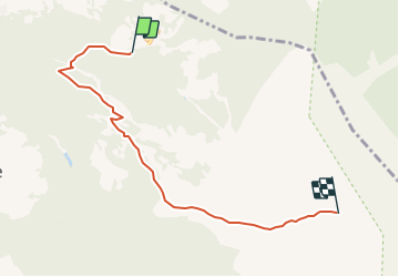
6,3 km | 9,8 km-effort
2h 13min
![](https://static1.geolcdn.com/siteimages/upload/files/16400158638029165_repeat_loop_refresh_sync_direction_icon.png)
No
![Excursión A pie Chalais - La Lé-refuge du Bisse - Photo](https://media.geolcdn.com/t/375/260/a00d1d58-cc60-4765-9e1b-00e885e38196.jpeg&format=jpg&maxdim=2)
![A pie A pie](https://static1.geolcdn.com/sitytour/trail-icons/100.png)
La Lé-refuge du Bisse
A pie
Fácil
Chalais,
Vallés,
Sierre,
Switzerland
![](/images/other/stat-length.png)
3,2 km | 5 km-effort
1h 7min
![](https://static1.geolcdn.com/siteimages/upload/files/16400158638029165_repeat_loop_refresh_sync_direction_icon.png)
No
![Excursión A pie Mont-Noble - L'Ar du Tsan - Le Louché Lac (B) - Photo](https://media.geolcdn.com/t/375/260/d60cf38c-77bf-4129-9294-d60e6b1dffc9.jpeg&format=jpg&maxdim=2)
![A pie A pie](https://static1.geolcdn.com/sitytour/trail-icons/100.png)
L'Ar du Tsan - Le Louché Lac (B)
A pie
Fácil
Mont-Noble,
Vallés,
Hérens,
Switzerland
![](/images/other/stat-length.png)
4,1 km | 8 km-effort
1h 49min
![](https://static1.geolcdn.com/siteimages/upload/files/16400158638029165_repeat_loop_refresh_sync_direction_icon.png)
No
![Excursión A pie Grône - Mayens de Réchy-Brie - Photo](https://media.geolcdn.com/t/375/260/ext.jpg?maxdim=2&url=https%3A%2F%2Fstatic1.geolcdn.com%2Fsiteimages%2Fupload%2Ffiles%2F1545311037marcheuse_200dpi.jpg)
![A pie A pie](https://static1.geolcdn.com/sitytour/trail-icons/100.png)
Mayens de Réchy-Brie
A pie
Fácil
Grône,
Vallés,
Sierre,
Switzerland
![](/images/other/stat-length.png)
6,3 km | 11,2 km-effort
2h 32min
![](https://static1.geolcdn.com/siteimages/upload/files/16400158638029165_repeat_loop_refresh_sync_direction_icon.png)
No
![Excursión Senderismo Sion - Vallon de la Borgne - Photo](https://media.geolcdn.com/t/375/260/ext.jpg?maxdim=2&url=https%3A%2F%2Fservices.sitytrail.com%2FGeolivesWS%2FDownloadMedia.ashx%3FTrailID%3D179263%26Media%3D1d92cacc-072f-4d73-b8f3-e811c293a794.jpg)
![Senderismo Senderismo](https://static1.geolcdn.com/sitytour/trail-icons/101.png)
Vallon de la Borgne
Senderismo
Medio
Sion,
Vallés,
Sion,
Switzerland
![](/images/other/stat-length.png)
14,2 km | 26 km-effort
5h 31min
![](https://static1.geolcdn.com/siteimages/upload/files/16400158638029165_repeat_loop_refresh_sync_direction_icon.png)
Sí
![Excursión Senderismo Saint-Léonard - Chemin du Vignoble - Photo](https://media.geolcdn.com/t/375/260/ext.jpg?maxdim=2&url=https%3A%2F%2Fservices.sitytrail.com%2FGeolivesWS%2FDownloadMedia.ashx%3FTrailID%3D44672%26Media%3Dimage5.jpg)
![Senderismo Senderismo](https://static1.geolcdn.com/sitytour/trail-icons/101.png)
Chemin du Vignoble
Senderismo
Muy fácil
Saint-Léonard,
Vallés,
Sierre,
Switzerland
![](/images/other/stat-length.png)
25 km | 37 km-effort
9h 0min
![](https://static1.geolcdn.com/siteimages/upload/files/16400158638029165_repeat_loop_refresh_sync_direction_icon.png)
No
![Excursión Otra actividad Mont-Noble - y10_eison_nax - Photo](https://media.geolcdn.com/t/375/260/ext.jpg?maxdim=2&url=https%3A%2F%2Fstatic1.geolcdn.com%2Fsiteimages%2Fupload%2Ffiles%2F1545311037marcheuse_200dpi.jpg)
![Otra actividad Otra actividad](https://static1.geolcdn.com/sitytour/trail-icons/900.png)
y10_eison_nax
Otra actividad
Muy fácil
Mont-Noble,
Vallés,
Hérens,
Switzerland
![](/images/other/stat-length.png)
13 km | 22 km-effort
5h 21min
![](https://static1.geolcdn.com/siteimages/upload/files/16400158638029165_repeat_loop_refresh_sync_direction_icon.png)
No
![Excursión Otra actividad Mont-Noble - y10_koehlerweg - Photo](https://media.geolcdn.com/t/375/260/ext.jpg?maxdim=2&url=https%3A%2F%2Fstatic1.geolcdn.com%2Fsiteimages%2Fupload%2Ffiles%2F1545311037marcheuse_200dpi.jpg)
![Otra actividad Otra actividad](https://static1.geolcdn.com/sitytour/trail-icons/900.png)
y10_koehlerweg
Otra actividad
Muy fácil
Mont-Noble,
Vallés,
Hérens,
Switzerland
![](/images/other/stat-length.png)
11,8 km | 23 km-effort
5h 2min
![](https://static1.geolcdn.com/siteimages/upload/files/16400158638029165_repeat_loop_refresh_sync_direction_icon.png)
Sí
![Excursión Senderismo Mont-Noble - NAX - lac de VERNAMIEGE - Photo](https://media.geolcdn.com/t/375/260/ext.jpg?maxdim=2&url=https%3A%2F%2Fstatic1.geolcdn.com%2Fsiteimages%2Fupload%2Ffiles%2F1553511878bg_sport_marche.png)
![Senderismo Senderismo](https://static1.geolcdn.com/sitytour/trail-icons/101.png)
NAX - lac de VERNAMIEGE
Senderismo
Fácil
Mont-Noble,
Vallés,
Hérens,
Switzerland
![](/images/other/stat-length.png)
9,2 km | 16,3 km-effort
4h 58min
![](https://static1.geolcdn.com/siteimages/upload/files/16400158638029165_repeat_loop_refresh_sync_direction_icon.png)
Sí