![](/images/other/stat-length.png)
![Excursión Senderismo Ramonchamp - Ramonchamp 06.07.14 - Photo](https://media.geolcdn.com/t/1900/400/ext.pjpeg?maxdim=2&url=https%3A%2F%2Fstatic1.geolcdn.com%2Fsiteimages%2Fupload%2Ffiles%2F1553511878bg_sport_marche.png)
Ramonchamp 06.07.14
joelclaudel
Usuario
![Longitud](/images/other/stat-length.png)
Longitud
10,3 km
![Altitud máxima](https://static1.geolcdn.com/siteimages/upload/files/1508320355ic_sort_altitude_max_24dp.png)
Altitud máxima
623 m
![Desnivel positivo](https://static1.geolcdn.com/siteimages/upload/files/1508320355ic_sort_den_pos_24dp.png)
Desnivel positivo
283 m
![Km-Effort](/images/other/stat-length.png)
Km-Effort
14,1 km
![Altitud mínima](https://static1.geolcdn.com/siteimages/upload/files/1508320355ic_sort_altitude_min_24dp.png)
Altitud mínima
463 m
![Desnivel negativo](https://static1.geolcdn.com/siteimages/upload/files/1508320355ic_sort_den_neg_24dp.png)
Desnivel negativo
283 m
![Boucle](https://static1.geolcdn.com/siteimages/upload/files/16400158638029165_repeat_loop_refresh_sync_direction_icon.png)
Boucle
Sí
Fecha de creación :
2014-12-10 00:00:00.0
Última modificación :
2014-12-10 00:00:00.0
![Senderismo](https://static1.geolcdn.com/sitytour/trail-icons/101.png)
3h03
Dificultad : Fácil
![Escanee este código QR para abrir la excursión en la aplicación SityTrail](https://capi.geolives.com/qq0zvz2zws4bq2lad0pu/sitytour/trails/321726/qr.png?size=200)
Aplicación GPS de excursión GRATIS
A propósito
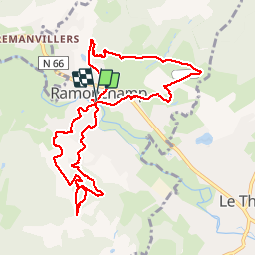
Ruta Senderismo de 10,3 km a descubrir en Gran Este, Vosgos, Ramonchamp. Esta ruta ha sido propuesta por joelclaudel.
Descripción
Circuit en "huit" au départ du parking de la salle des Fêtes de Ramonchamp.
La filature, la Ravanne, Grammont,retour centre du village, l'Etraye, la Roche Joly, sentier botanique et retour parking.
Localización
País:
France
Región :
Gran Este
Departamento/provincia :
Vosgos
Municipio :
Ramonchamp
Localidad:
Unknown
Salida:(Dec)
Salida:(UTM)
330998 ; 5306809 (32T) N.
Comentarios
Excursiones cerca
![Excursión Senderismo Le Ménil - Boucle au départ des chalets de la](https://media.geolcdn.com/t/375/260/a828a9f3-0482-4d5b-86c2-c919e4b59d9f.jpg&format=jpg&maxdim=2)
![Senderismo Senderismo](https://static1.geolcdn.com/sitytour/trail-icons/101.png)
Boucle au départ des chalets de la "Vosges Attitude"
Senderismo
Fácil
(3)
Le Ménil,
Gran Este,
Vosgos,
France
![](/images/other/stat-length.png)
10 km | 14,1 km-effort
3h 0min
![](https://static1.geolcdn.com/siteimages/upload/files/16400158638029165_repeat_loop_refresh_sync_direction_icon.png)
Sí
![Excursión Senderismo Beulotte-Saint-Laurent - Randonnée des étangs - Beulotte Saint Laurent - Photo](https://media.geolcdn.com/t/375/260/ext.jpg?maxdim=2&url=https%3A%2F%2Fservices.sitytrail.com%2FGeolivesWS%2FDownloadMedia.ashx%3FTrailID%3D107231%26Media%3D12098_5.jpg)
![Senderismo Senderismo](https://static1.geolcdn.com/sitytour/trail-icons/101.png)
Randonnée des étangs - Beulotte Saint Laurent
Senderismo
Medio
(4)
Beulotte-Saint-Laurent,
Borgoña-Franco Condado,
Alto Saona,
France
![](/images/other/stat-length.png)
10,7 km | 13,9 km-effort
2h 30min
![](https://static1.geolcdn.com/siteimages/upload/files/16400158638029165_repeat_loop_refresh_sync_direction_icon.png)
Sí
![Excursión A pie Fresse-sur-Moselle - Les ballons à l’horizon - Photo](https://media.geolcdn.com/t/375/260/30df9189-1183-47e3-a585-be073639a450.jpeg&format=jpg&maxdim=2)
![A pie A pie](https://static1.geolcdn.com/sitytour/trail-icons/100.png)
Les ballons à l’horizon
A pie
Fácil
Fresse-sur-Moselle,
Gran Este,
Vosgos,
France
![](/images/other/stat-length.png)
7,7 km | 12,6 km-effort
2h 51min
![](https://static1.geolcdn.com/siteimages/upload/files/16400158638029165_repeat_loop_refresh_sync_direction_icon.png)
Sí
![Excursión Senderismo Beulotte-Saint-Laurent - Beulotte-Saint-Laurent 13 700m + 317m - Photo](https://media.geolcdn.com/t/375/260/ext.jpg?maxdim=2&url=https%3A%2F%2Fstatic1.geolcdn.com%2Fsiteimages%2Fupload%2Ffiles%2F1553511878bg_sport_marche.png)
![Senderismo Senderismo](https://static1.geolcdn.com/sitytour/trail-icons/101.png)
Beulotte-Saint-Laurent 13 700m + 317m
Senderismo
Fácil
(1)
Beulotte-Saint-Laurent,
Borgoña-Franco Condado,
Alto Saona,
France
![](/images/other/stat-length.png)
13,7 km | 17,9 km-effort
3h 50min
![](https://static1.geolcdn.com/siteimages/upload/files/16400158638029165_repeat_loop_refresh_sync_direction_icon.png)
Sí
![Excursión Senderismo Haut-du-Them-Château-Lambert - Chateau-Lambert mines de cuivre et source de l'Oignon - Photo](https://media.geolcdn.com/t/375/260/ext.jpg?maxdim=2&url=https%3A%2F%2Fstatic1.geolcdn.com%2Fsiteimages%2Fupload%2Ffiles%2F1553511878bg_sport_marche.png)
![Senderismo Senderismo](https://static1.geolcdn.com/sitytour/trail-icons/101.png)
Chateau-Lambert mines de cuivre et source de l'Oignon
Senderismo
Fácil
(1)
Haut-du-Them-Château-Lambert,
Borgoña-Franco Condado,
Alto Saona,
France
![](/images/other/stat-length.png)
9,6 km | 14,6 km-effort
2h 30min
![](https://static1.geolcdn.com/siteimages/upload/files/16400158638029165_repeat_loop_refresh_sync_direction_icon.png)
Sí
![Excursión Senderismo Ramonchamp - Tournée de 3 chalets - Photo](https://media.geolcdn.com/t/375/260/9772d619-fbbf-4858-9b6a-d813a318e1c1.jpeg&format=jpg&maxdim=2)
![Senderismo Senderismo](https://static1.geolcdn.com/sitytour/trail-icons/101.png)
Tournée de 3 chalets
Senderismo
Medio
Ramonchamp,
Gran Este,
Vosgos,
France
![](/images/other/stat-length.png)
6,2 km | 9 km-effort
2h 3min
![](https://static1.geolcdn.com/siteimages/upload/files/16400158638029165_repeat_loop_refresh_sync_direction_icon.png)
Sí
![Excursión Senderismo Fresse-sur-Moselle - Croix de Fresse - Vosges - France - Photo](https://media.geolcdn.com/t/375/260/1bf27e15-8257-4a1e-ac29-4caf5b1917b2.jpg&format=jpg&maxdim=2)
![Senderismo Senderismo](https://static1.geolcdn.com/sitytour/trail-icons/101.png)
Croix de Fresse - Vosges - France
Senderismo
Medio
(1)
Fresse-sur-Moselle,
Gran Este,
Vosgos,
France
![](/images/other/stat-length.png)
13,4 km | 19,6 km-effort
3h 10min
![](https://static1.geolcdn.com/siteimages/upload/files/16400158638029165_repeat_loop_refresh_sync_direction_icon.png)
Sí
![Excursión Senderismo Beulotte-Saint-Laurent - Beulotte St Laurent - le plateau des Mille Etangs - Photo](https://media.geolcdn.com/t/375/260/e526a3c8-361b-4678-a970-15d98b11e7c3.jpg&format=jpg&maxdim=2)
![Senderismo Senderismo](https://static1.geolcdn.com/sitytour/trail-icons/101.png)
Beulotte St Laurent - le plateau des Mille Etangs
Senderismo
Difícil
Beulotte-Saint-Laurent,
Borgoña-Franco Condado,
Alto Saona,
France
![](/images/other/stat-length.png)
22 km | 28 km-effort
4h 45min
![](https://static1.geolcdn.com/siteimages/upload/files/16400158638029165_repeat_loop_refresh_sync_direction_icon.png)
Sí
![Excursión Senderismo Le Thillot - Col des Croix - Vierge des Neiges - Hautes Mines - Tête des Noirs Étangs - Château Lambert - Photo](https://media.geolcdn.com/t/375/260/dd7bdea5-b733-4b98-94f9-1f87ee811abf.jpg&format=jpg&maxdim=2)
![Senderismo Senderismo](https://static1.geolcdn.com/sitytour/trail-icons/101.png)
Col des Croix - Vierge des Neiges - Hautes Mines - Tête des Noirs Étangs - Ch...
Senderismo
Fácil
Le Thillot,
Gran Este,
Vosgos,
France
![](/images/other/stat-length.png)
10,5 km | 16 km-effort
2h 23min
![](https://static1.geolcdn.com/siteimages/upload/files/16400158638029165_repeat_loop_refresh_sync_direction_icon.png)
Sí